This week, we have already seen significant rainfall across large parts of the country. Now a cold front will be added to the mix, leading to another round of rain, severe storms and gusty winds.
This week’s rain was caused by a series of low-pressure troughs that brought about a month’s worth of rain to parts of inland NSW, QLD, VIC and SA. On Wednesday, October 5, solid falls were experienced in NSW and VIC. Some of the readings of note included:
- Bourke’s wettest October day in 67 years.
- Lake Cargelligo in NSW saw its largest October daily rainfall total in 37 years.
- Camden in Sydney’s southwest observed 51.2mm in 24 hours, which is the wettest October day in 23 years.
- While not quite as heavy in Vic, every single rain gauge across the state recorded rainfall.

Image: Daily rainfall observations on Wednesday, October 5. Source: Bureau of Meteorology.
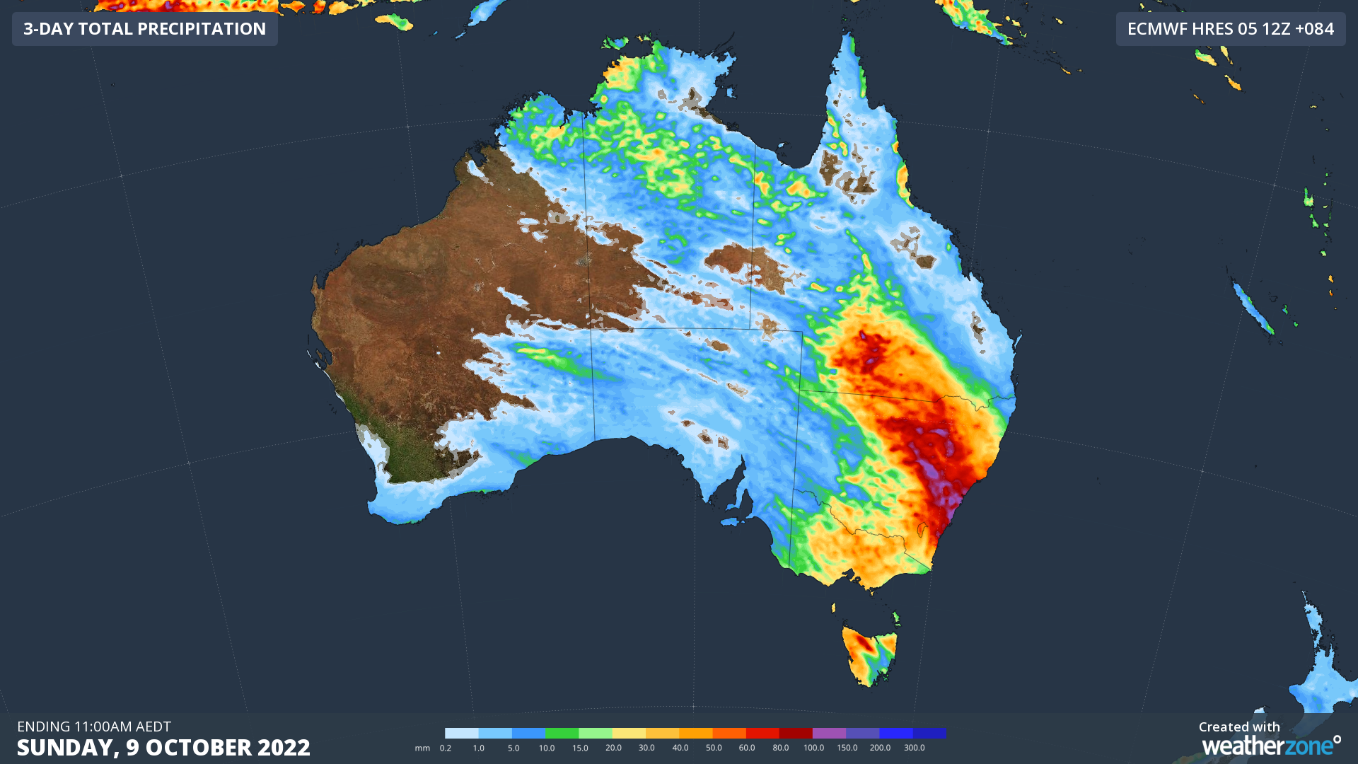
The next system sweeping across the east is a cold front that will once again tap into the tropical moisture over northern Australia. Overall, widespread falls of 20-50mm with isolated pockets of more than 100mm are expected over the next four days over southern Qld, NSW, Vic and northern Tas. Here is how this front will play out day-by-day:

Image: ECMWF 3-day rainfall forecast to 11am Sunday, October 9.
Thursday
Showers and gusty southwesterly winds will sweep across SA, western NSW, western Vic and northern Tas as the front and trough move through. Some isolated thunderstorms are also expected over northern parts of SA and NSW. Rainfall will be patchy, so widespread falls of 2-8mm are most likely, but some areas will see 20-40mm with heavier showers and storms.

Image: Access-G 24hr rainfall forecast to 11pm Thursday
Friday
Friday should be the biggest day of the week with widespread rain, severe thunderstorms and flooding all on the forecast. This comes as the low-pressure trough links up with an atmospheric river delivering large amounts of moisture to eastern Australia. Severe thunderstorms should be widespread in the afternoon, with heavy rainfall, large hail and damaging winds all on the cards through western Qld, NSW and VIC. Widespread falls of 10-30mm are expected, but quite a few heavier patches of 60-100mm will come along with storms.

Image: Access-G 24hr rainfall forecast to 11pm Friday
Saturday
Persistent and heavy rainfall will impact southwest Qld and northeastern NSW as a trough lingers stalls over the region. Daily falls of 20-50mm are likely for most of these areas, with isolated falls of more than 80mm possible.

Image: Access-G 24hr rainfall forecast to 11pm Saturday
Sunday
A low-pressure system will rapidly deepen off the NSW coast, directing strong winds, rough seas and heavy rain across eastern NSW. The heaviest rain looks to fall between Newcastle and the South Coast with 30-70mm expected. Luckily, this low will not stick around too long, as it will continue to move out to sea during the day.

Image: Access-G 24hr rainfall forecast to 11pm Sunday
The silver-lining to this wet week is a broad high pressure system moving in from the weekend, allowing skies to clear and days to warm up early next week.
All this rainfall is already warranting flood watches and warnings, with more warnings likely to be issued over the coming days. Stay up to date with the latest warnings here.
For more information on our flood risk and accumulated rainfall forecasts, please contact us at apac.sales@dtn.com.