Prosper in a dynamic world
Search

Rain returning to flood-weary NSW, Vic and Qld

Rain and thunderstorms will spread over southeastern and eastern Australia during the next three days, dumping more water into already flooded rivers across several states.

Since the beginning of September, a series of rain and storm-bearing low pressure troughs have delivered two-to-four months’ worth of rain in parts of eastern Australia.

This frequent and substantial rainfall has caused flooding in several states, with numerous flood warnings currently in place from southern Qld down to northern Vic, including a large swathe of NSW.

The map below shows the month-to-date rainfall percentages, with blue shading representing areas that have already seen more than 200 percent of their average rainfall so far this month.
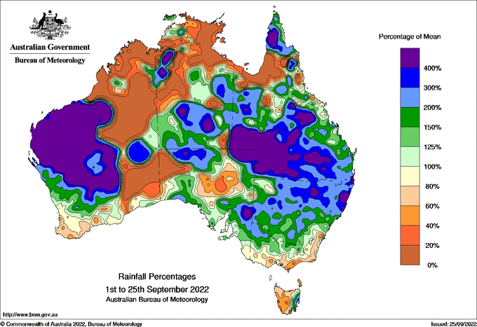
Image: Observed September month-to-date rainfall percentages. Source: Bureau of Meteorology.

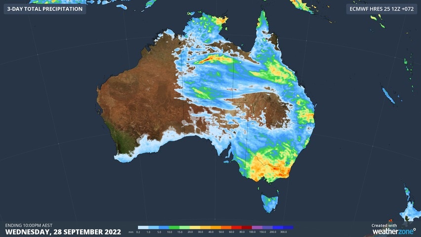
A cut-off upper-level low and an associate surface trough will interact with moisture-laden air to cause widespread showers and storms in parts of SA, NSW, the ACT, Qld, Vic, Tas and the NT between now and Wednesday.

The heaviest rain from this system is likely to fall over Vic and southern NSW, where renewed river level rises may cause flooding. There is also potential for severe thunderstorms in several states during the next three days.

Image: Forecast accumulated rain between Monday and Wednesday according to the ECMWF-HRES model.

Be sure to check the latest flood and thunderstorm warnings for the most up-to-date information as this event unfolds.

For more information on our products or how we can help you with your business needs, please contact us at apac.sales@dtn.com

Latest news

Satisfy your weather obsession with these news headlines from around the nation, and the world.

Another burst of heat looming for southeastern Australia

The first week of summer is set to arrive with a bang, with hot and humid conditions expected for at least five states and territories next week.   A blocking high pressure system in the Tasman Sea will direct hot northerly winds across southeastern Australia for much of next week.   This slow pattern will […]

Stormy start to summer looms for Australia

A volatile weather pattern is set to cause widespread thunderstorm activity over Australia throughout the first week of summer, with severe storms likely to hit multiple states and territories. The last week of spring is featuring prolific rain and thunderstorm activity over large areas of northern and eastern Australia. This wet and stormy weather will […]

Tropical Cyclone Robyn forms in Australian region

Tropical Cyclone Robyn has formed inside Australia’s area of responsibility, becoming the first named cyclone of the 2024-25 season. Robyn became a category one tropical cyclone over the eastern Indian Ocean on Thursday afternoon, forming roughly 740 km to the west southwest of the Cocos (Keeling) Islands at about 2pm AWST. Image: Visible satellite images […]

Colossal conveyor belt of tropical moisture

A vast area of northern and eastern Australia is set to see persistent rainfall and thunderstorm activity in coming days, with the potential for flooding in many areas. If you want to understand why, the image at the top of this story explains all. The image shows the amount of “precipitable water” in the atmosphere, […]