
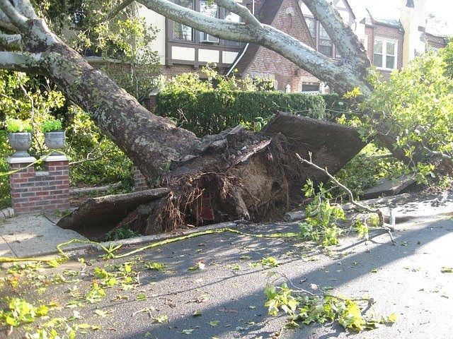
Damaging winds are a common feature in Australian severe weather and thunderstorm warnings. But did you know that some types of wind are more dangerous than others?
There are three things that can make the wind dangerous: strength, duration and direction.
The most obvious damaging feature of wind is its strength, which is typically measured in two ways:
- Average or mean wind speed = the wind speed averaged over a 10-minute period.
- Wind gusts = sudden increases in wind for a short duration, typically a few seconds.
As a rule of thumb, wind gusts are usually about 40 percent stronger than the average wind speed over open water.
In Australia, warnings are issued for:
- Damaging winds – when wind gusts of 90km/h or more are expected to occur.
- Destructive winds – when wind gusts are likely to reach 125 km/h or higher.
Wind damage can be predicted using the Beaufort Wind Scale, which was first developed over 200 years ago and is still used widely today.
While its original purpose was to estimate wind speeds based on the damage they caused, the Beaufort Scale can also be used the other way, to anticipate what impacts are likely from the predicted wind speeds.
Sustained wind speeds (10-minute average) of 40-50 km/h can cause large branches to sway and make it difficult to use an umbrella.
Wind speeds averaging 76-87 km/h can break large branches off trees, dislodge roofing and cause crests of waves to start toppling over in open water.
Wind speeds of 88-102 km/h are capable of uprooting trees and causing significant structural damage to buildings. A more comprehensive breakdown of typical impacts for different wind speeds is shown below.
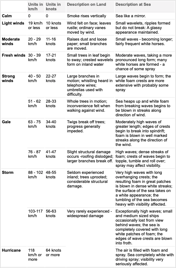
Image: Wind speeds (10-minute average) and their associated impacts, produced by the Bureau of Meteorology from the Beaufort Wind Scale.
In addition to the peak wind speeds, the duration of damaging wind storm can exacerbate its impacts.
One of the reasons tropical cyclones, hurricanes and typhoons are so damaging is because of their large size, which exposes a broad area to damaging or destructive winds for hours on end.
Back in September 2019, Hurricane Dorian stalled over Grand Bahama for around 24 hours. This extremely slow-moving and powerful hurricane caused extensive flooding and damage across the island, with the Grand Bahama International Airport left in tatters.
In addition to wind speeds and duration, the wind direction also plays big role in determining how severe the damage will be.
A landscape that is accustomed to prevailing winds from the west or north is likely to see more damage or destruction when powerful winds blow in from the east or south.
This was one of the contributing factors to a wind and rain event that brought down a large number of trees in Victoria’s Dandenong Ranges in June 2021.
The Dandenongs usually experience their strongest winds from the north or southwest. However, the wind during this event came from the south and southeast. Trees that had grown their root systems to withstand northerly-component winds were blindsided by powerful and persistent southeasterlies coming up from Bass Strait.
.jpg)
Image: Damage in the Dandenongs after powerful winds toppled trees in June, 2021. Source: @photography_trh / Instagram
The risk of tree and infrastructure damage in events like this can be exacerbated even further by heavy rain, which helps soften the soil and adds weight to the tree’s branches and leaves.
Weatherzone and DTN have the solution.
Weatherzone can help utilities transform their emergency management practices to proactively plan response and restoration efforts before severe weather-related outage events. Storm Impact Analytics is a damage and outage incident prediction system, developed by Weatherzone’s parent company DTN, that uses a machine learning-based approach to provide a set of quantitative predictions that support a more prepared response.
The outage prediction model considers high winds, temperature, precipitation, atmospheric instability, and more to determine the strength of incoming storms and the associated risks at various time horizons. This weather modelling is combined with non-weather data – such as historic utility outages, utility asset records, vegetation and other variables – and finally machine learning predictive analytics to determine the impact of weather on the utility across specific geographical regions.
This is then translated into impact information, such as the potential number of incidents, customer outages, and restoration effort estimates. This enables utilities to plan, make decisions and deploy restoration crews to the risk area/s, ensuring minimal service disruptions.
How can this system assist utility emergency preparedness managers?
The Storm Impact Analytics solution has been developed to respond to some of the most common questions that utility emergency preparedness managers are facing when extreme weather is on the horizon:
- Which assets are at risk?
- What might be the extent of damage of the assets at risk?
- Which customers could be potentially affected by the forecasted severe weather?
- Which past events are most like this forecasted storm?
- How to plan better for the workforce and inventory of materials that will be critical for restoration efforts?
Improving your outage response strategy and preparing for storms can help reduce your cost recovery.
The Multi-Hazard Mitigation Council estimates that every dollar spent reducing risk before an event such as a flood, or extreme winds, storm surge, wind extreme or wildfire saves up to 10 dollars that would otherwise need to be spent on recovery and response.
The system also enables emergency preparedness managers and their companies to have additional insight into infrastructure resiliency.
Storm Impact Analytics and its machine-learning models are integrated with the Weatherzone platform and include real-time monitoring by local, expert meteorologists, making it far more sophisticated than other methods.
Weatherzone can alert businesses of strong wind and thunderstorms which could impact your businesses out to 14 days. For more information, please contact us at apac.sales@dtn.com.




