Strong and gusty winds will produce several days of strong wind power across the National Electricity Market (NEM) this week.
The satellite image below shows a band of cloud associated with a cold front and low pressure system passing southern on Tuesday afternoon.

This low pressure system will extend multiple fronts across southeastern Australia between Wednesday and Sunday causing several days of strong winds.
The strongest winds over the next 48 hours are expected across SA as the low-pressure system remains almost stationary in the Bight.
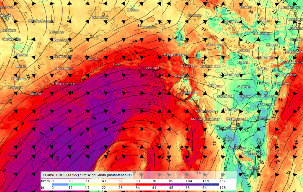
The image below shows one model’s wind gust forecast on Thursday afternoon.

Image: ECMWF wind gust forecast at 4pm on Thursday, September 15.
Another burst of powerful winds is expected to impact much of southeastern Australia on Friday and Saturday another strong cold front sweeps across the region. Damaging wind warnings could be issued across southern SA and VIC on Saturday as this surge of wind impacts the area.
The map below shows the strong winds impacting much of the NEM on Friday and Saturday afternoon.


Image: ECMWF wind gust forecast at 1pm on Friday (top) and Saturday (below), September 16 and 17.
The fierce winds will continue across eastern Australia on Sunday before easing across much of the NEM on Sunday.
Are all wind speeds good for wind farms?
Strong winds are usually great news for wind farms. However, sometimes the winds are too strong. There is a sweet spot when it comes to wind power.
Wind gusts above 90km/h (25m/s) can damage the wind turbines and the propellers if they are spinning.
Wind farms may have to turn the turbines off if the winds reach the ‘cut-off’ wind speeds (25m/s) to ensure the strong winds do not damage the turbine.
If the winds are too strong, wind power capacities may be reduced for periods of time when the turbines are turned off.
Unfortunately for SA wind farms, the wind gusts during the next few days may exceed the cut-out criteria, potentially forcing the wind farms to turn the propellers off.
How can Weatherzone help you harness the power of this wind?
DTN APAC, a DTN company, offers wind and power generation forecasting to assist in determining your wind farm’s output, reducing costly errors.
Whether you have an existing windfarm, or looking for an optimal wind farm location, we provide crucial data to give you greater awareness of your generation capacity. From vertical wind profiling, to identifying alternative scenarios and RAMP events, we have you covered. We can assist with:
Rapid Update Forecasting – 5-minute forecasting up to 72 hours and hourly forecasting out to 10 days for full awareness.
RAMP Event Prediction – Understand when significant generation impacts will occur so you can mitigate risk.
Advanced Generation Forecasting-Multi-level wind profiles, meta-data management and input data QC ensures precision.
We work closely with you, pushing the boundaries of science and technology, to identify and fulfil your individual business needs. A tailored and consolidated solution, making your everyday more effective. For more information, please contact us at apac.sales@dtn.com.


