During the past week, heavy rainfall, gale force winds and flooding across eastern NSW caused significant disruptions across many rail networks. Flooding, landslides and trees on tracks all contributed to the delays or cancellations this week.
Now, the NSW rail network have the challenging task of repairing track damage and clearing debris quickly so services can return to normal.
So, how does flood water or heavy rainfall impact rail lines?
- Flood water can block the lines or trains must reduce speed.
- Deposit debris, silt and mud onto the track.
- Flood water can wash away the bed of stones that supports the railway sleepers.
- Points and signalling equipment can fail during flooding.
- Heavy rain can overwhelm the drainage systems on the railway making flooding more likely.
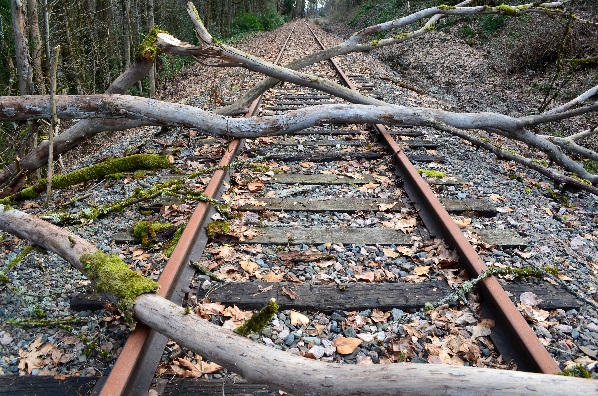
- Heavy rain and flooding can cause landslides or cause trees to fall on the lines.
Gale force winds can also cause significant problems for the rail industry, with debris trees and other forms of vegetation likely to fall on the track. The debris must be cleared before the service continues, again causing delays and cancellations.

Strong winds can bring down trees in rain-softened soil with ease, following or during a heavy rain or flooding event like we saw this week.
Trees can also hit overhead power lines, which can sever connections or knock down masts.
Strong winds or adverse weather can also delay the cleanup and repair of the rail tracks.
It is not safe in high winds for engineers to work at a height repairing lines these works will often be delayed.
How does Weatherzone alert our rail and transport clients of upcoming severe weather?
The transport and rail sector are very much exposed to these severe weather events and storm outbreaks and we can assist the rail and transport industry to avoid operational delays, maintenance disruption and safety issues. Weatherzone provides heat/cold temperature, thunderstorm, fog, lightning, and heavy rainfall alerts for every track section based on our clients’ thresholds.
Early Warning Systems, Dangerous storm alerts (DTA’s) and post event analysis and summaries also help the rail industry to plan maintenance and manage manpower around severe weather events. For more information, please contact us at apac.sales@dtn.com.


