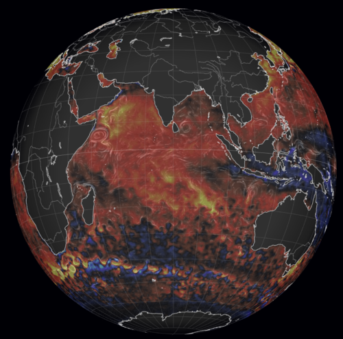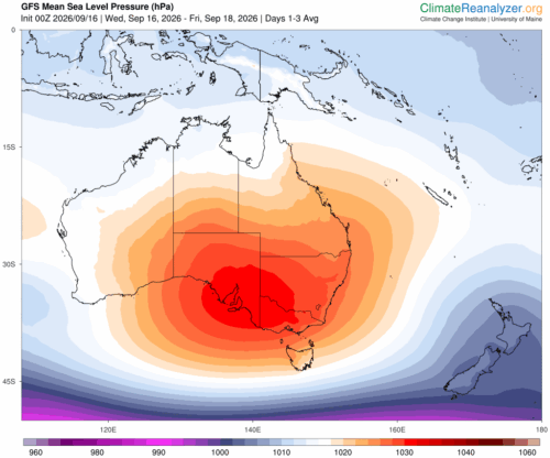

A positive Indian Ocean Dipole is underway, but this one is unlikely to deliver the textbook dry spring and summer that businesses have come to expect from the pattern.
The Bureau of Meteorology officially declared a positive IOD on Tuesday, October 27, which typically like El Niño can cause drier and warmer conditions over parts of Australia.
The Indian Ocean Dipole (IOD) is an index that measures the difference in sea surface temperature anomalies across the tropical Indian Ocean. It is calculated by comparing the anomalies in two defined regions:
- The IOD East region, which sits to the southwest of Indonesia
- The IOD West region, which lies off the east coast of Africa, near the Horn of Africa
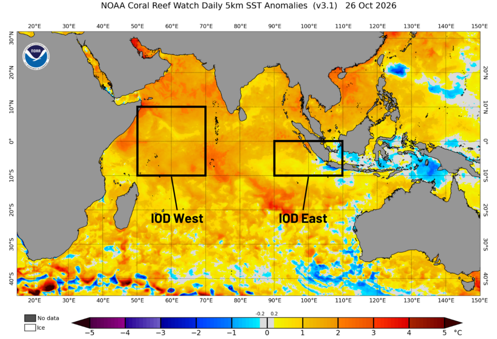 Image: Sea surface temperature anomalies in the Indian Ocean on October 26, 2026. The IOD West and IOD East regions are highlighted. Source: NOAA.
The IOD fluctuates between positive, neutral and negative phases.
A positive IOD occurs when sea surface temperatures are cooler than average in the IOD East region and warmer than average in the IOD West region. This phase is typically associated with abnormally warm and dry weather in Australia, particularly in winter and early summer.
However, despite Tuesday’s declaration warm water covers almost the whole Indian Ocean basin, with only a small cool pocket near Indonesia, and that warmth is feeding tropical moisture into Australia. This is generating more northwest cloud bands and thunderstorm rain than the classic positive IOD would suggest. The more probable outcomes of the 2026 positive IOD are a delayed monsoon, a longer fire season in the north and a later start to cyclone activity.
Where the event stands
The IOD index has stayed at or above the positive threshold of +0.4 °C for seven consecutive weeks and reached +0.69 °C for the week ending 25 October 2026.
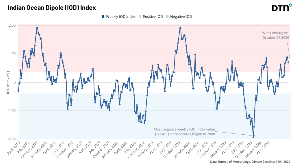
Values are forecast to stay positive. All international models assessed agree the event will persist through spring and return to neutral in early summer, which fits the usual life cycle of an IOD event.
The sea surface temperature analysis for the same week shows waters up to 3 °C above average around most of Australia’s west, south and south-east. Waters to the north and north-east, in the Arafura and Coral seas, are average to slightly below average. Those areas are forecast to warm over the coming months, particularly the north and the Coral Sea.
Why this event may not behave like a typical positive IOD
The classic positive IOD pairs warm water in the western Indian Ocean with cool water in the east, off Indonesia and Sumatra. That temperature gradient shifts convection away from Australia’s northwest, so there is less moisture, fewer northwest cloud bands and less rain across the north and east. Winter and spring in past positive IOD years have typically run drier and warmer across much of the continent.
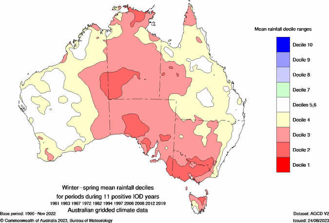
The current satellite picture is different. The cool anomaly is confined to a small area around the Indonesian archipelago and nearby seas, while the rest of the basin, from the Arabian Sea and the equatorial Indian Ocean to the waters off Western Australia, is running well above average, with large areas at +1 to +2 °C and some patches higher. The eastern cool pole is much weaker than the textbook case, and that matters because it is the contrast that normally drives the drying signal.
Warm water across that much of the basin supports a steady supply of tropical moisture toward Australia. That raises the chance of northwest cloud bands and of rain and thunderstorm events, particularly across the west and interior. The usual positive IOD impacts remain possible, but the warm basin offers a plausible reason why they may be muted, and why business planning should not simply assume a classic dry year. This is a judgement based on the current SST pattern, not a certainty, and the cool pocket near Indonesia could still influence the timing of the monsoon.
What the rainfall outlook shows
The ECMWF SEAS5 monthly rainfall anomalies, issued October 2026, show a wet signal across the interior and parts of the south and east early on, with a drying signal building across the north from December. That sequence is consistent with warm-basin moisture arriving in the south and west first, and with a monsoon that is slow to arrive.
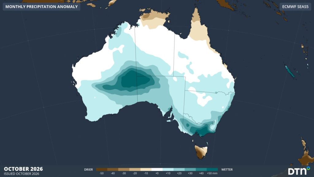
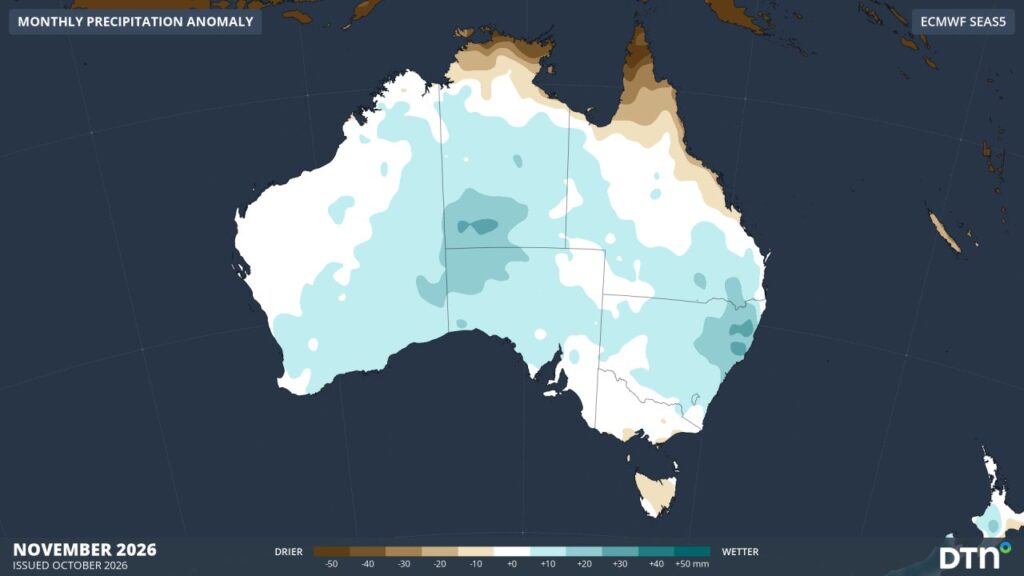
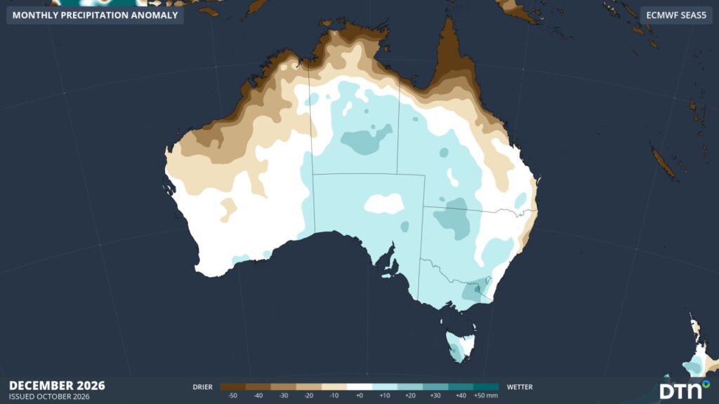
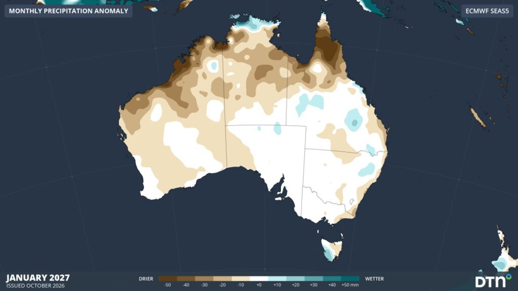
Images: ECMWF SEAS5 monthly rainfall anomalies for October, November and December 2026 and January 2027 (top to bottom)
The northern tropics are the notable feature. A drying signal across the Kimberley, Top End and Cape York that strengthens into January points to a slow start to the wet season, rather than a normal December onset.
Monsoon, fire season and cyclones: the timing risks
A later monsoon.
Like El Niño, a positive IOD can delay the onset of the Australian monsoon. Cooler water near Indonesia suppresses convection over the Maritime Continent, and that is the engine that normally helps pull the monsoon trough south in late spring. Even with a weak cool pole, the dry signal across the north from December in the outlook above points to the same risk. The expectation is a later and possibly less organised start, not a failed season, and warm waters to the north and in the Coral Sea may help rainfall ramp up quickly once the monsoon does arrive.
A longer fire season.
In the tropical north, fire season runs until the wet season starts, so each week of delay extends it. A slow monsoon also means more of the north stays hot and dry through the build-up. Further south, the wetter spring outlook for the interior and parts of the south-east can boost grass growth, and that fuel can cure into a fire risk if summer turns hot and dry.
Cyclone activity pushed later.
A typical Australian region season brings 9 to 10 tropical cyclones, about 4 of which cross the coast, and the first coastal crossing usually comes in late December. Seasons have also trended lower, by around one cyclone every 11 years on the Bureau of Meteorology record. A delayed monsoon usually means a delayed cyclone season, because cyclones need monsoon-type conditions to form. The most likely outcome is a quiet November and early December, with activity concentrated in late summer. The risk is not removed. Warm Coral Sea waters can fuel rapid intensification when systems do form, so a quiet start should not be read as a mild season overall.
What it means for businesses across Australia
The common thread is timing and variability rather than a uniform dry year. Operations planned around a classic positive IOD, or around a normal December monsoon, are exposed in both directions. The sector view below is a planning guide drawn from the patterns described above, not a forecast for any single site.
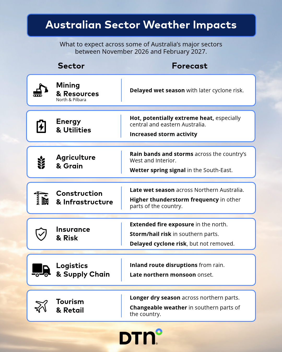
Image: Australian Sector Weather Impacts between November 2026 and February 2027. Source: DTN APAC Risk Communicators.
This positive IOD is real, but the warm Indian Ocean basin means it is unlikely to act as a simple drying switch. Expect more moisture than the textbook pattern implies, with the main risks being a later monsoon, a longer northern fire season and a cyclone season that starts late but can still be damaging.
Prepare for Weather Risks and Uncertainty with DTN APAC
It’s more important now than ever to optimise your team and operation’s resilience against the uncertain timing and variability of seasonal weather risks.
DTN APAC Risk Communicators work closely with operators across major industries to support risk management planning, provide situational awareness, and post-event reporting when extreme weather hits hard. This includes proactive monitoring of weather forecasts 5-14 days out and medium-range climate forecasts up to 6 weeks in advance.
With expert support on hand, you can make tailored informed decisions in a timely manner to mitigate risks, keep operations going, and protect your assets and people.