
WA’s remote mining regions have been impacted by thunderstorm, lightning and heavy rainfall only detectable using remote sensing methods.
Nearly 300,000 lightning strikes detected across WA
DTN Total Lightning Network (TLN) detected over 288,000 lightning strikes above Western Australia between Wednesday and Sunday, August 26-30, 2026. A vast majority of this lightning was observed over WA’s remote mining regions, with severe thunderstorms also impacting the transportation industry.
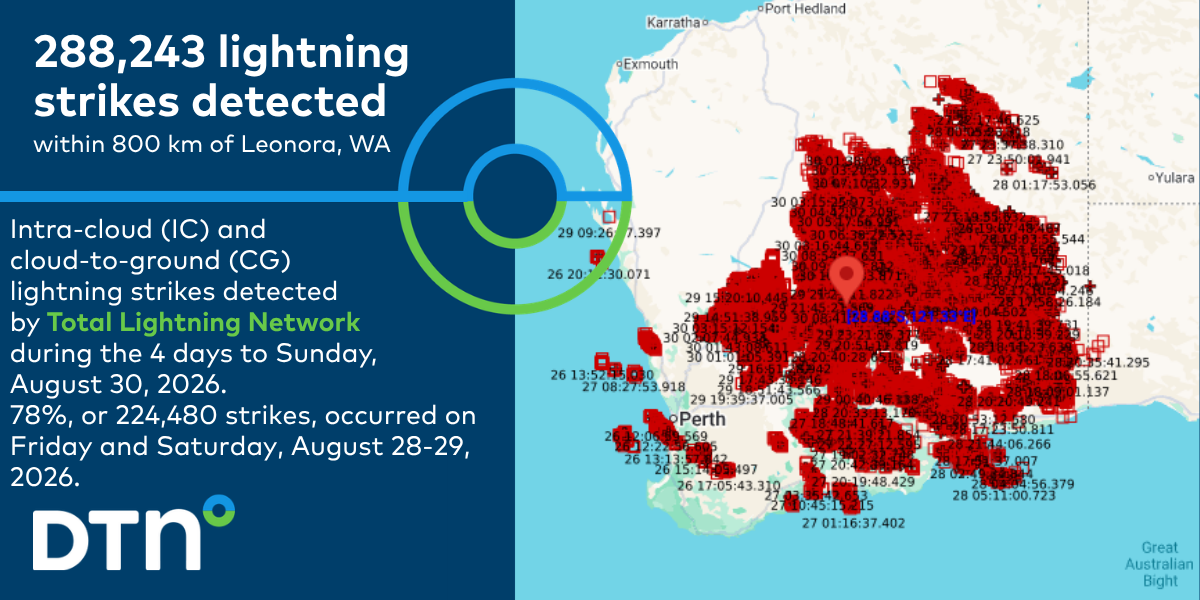
Image: DTN Total Lightning Network detected nearly 300,000 lightning strikes across WA between Wednesday and Sunday, August 26-30, 2026. Source: DTN.
This extensive lightning and thunderstorm activity has been triggered by a broad low pressure trough extending over the state, supported by a slow-moving upper-level low pressure system increasing instability over the last few days.
Video: Satellite imagery, radar and lightning detected across WA between Thursday and Sunday, August 27-30, 2026, as seen on DTN StormTracker dashboard. Source: DTN.
As seen in the video above, thunderstorm and lightning activity was most intense on Friday and Saturday, with over 121,000 and 103,000 lightning strikes recorded on each day, respectively. Across that 48-hour period, 78% of the nearly 300,000 lightning strikes were detected.
Lightning brings a serious risk of injuries and death to outdoor workers, significant damages to assets and vehicles, and general disruptions to operations. The DTN Total Lightning Network is a key consideration across many mining, transport, utilities, port and maritime operations. If your business or supply chain operates out in the open or in the air, your company could be at risk.
With thunderstorms a regular feature in Australia in the coming season, DTN allows you to visualise approaching storms as our customisable GIS system, Stormtracker, plotting lightning strike data across your site and infrastructure. This enables enhanced understanding of the potential risk inherent in each severe weather system and how storms produce hazardous conditions. Integrated satellite technology improves tracking accuracy, while real-time weather forecasts provide deeper insights into developing thunderstorm activity and potential disruptions.
Personal push notifications give users real-time severe weather and lightning alerts, based on their phone’s GPS position, enhancing their awareness of personal risk. Users can see lightning as it happens and track associated precipitation, ensuring more informed decision-making.
Lightning strike history is archived for over five years, enabling you to extract the reportable data required for risk assessments or insurance claims, with advanced calculation tools ensuring precise analysis.
Widespread healthy rainfall spreads across WA’s agricultural lands
Along with prolific wintertime lightning activity, this system tapped into a deep moisture source and drenched the landscape across the South West Land Division of WA, including key agricultural lands.
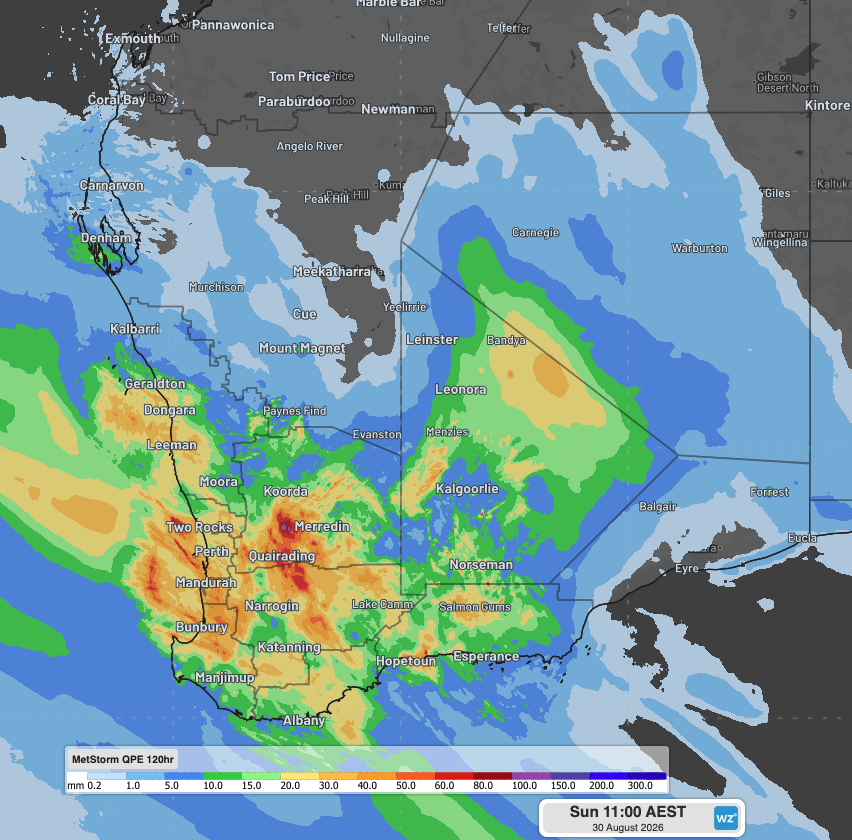
Image: DTN’s Quantitative Precipitation Estimates (QPE) showing 4-day rainfall across WA since Wednesday morning, August 26, 2026. Source: DTN.
Widespread falls of 20-40mm have been registered over the past 4 days extending as far north as Geraldton, south to Albany and Esperance, and inland across the Goldfields. Agricultural lands of the Central Wheat Belt and Great Southern regions also received more intense rainfall of 50-100mm over the last few days.
How DTN APAC is helping remote mining, transport, fire services and agricultural industries with advanced weather intelligence, remote sensing and now-casting solutions during the severe weather season
Australia is a vast country with densely populated coastal areas across the south and east, and millions of square kilometres of sparsely populated, resource-rich land elsewhere.
Typical radar coverage extends to a radius of about 200km, however mountains, trees and towers can restrict this optimal coverage range. Even with over 60 radar sites operating across Australia, vast expanses of the outback and WA remain outside of this traditional radar coverage.
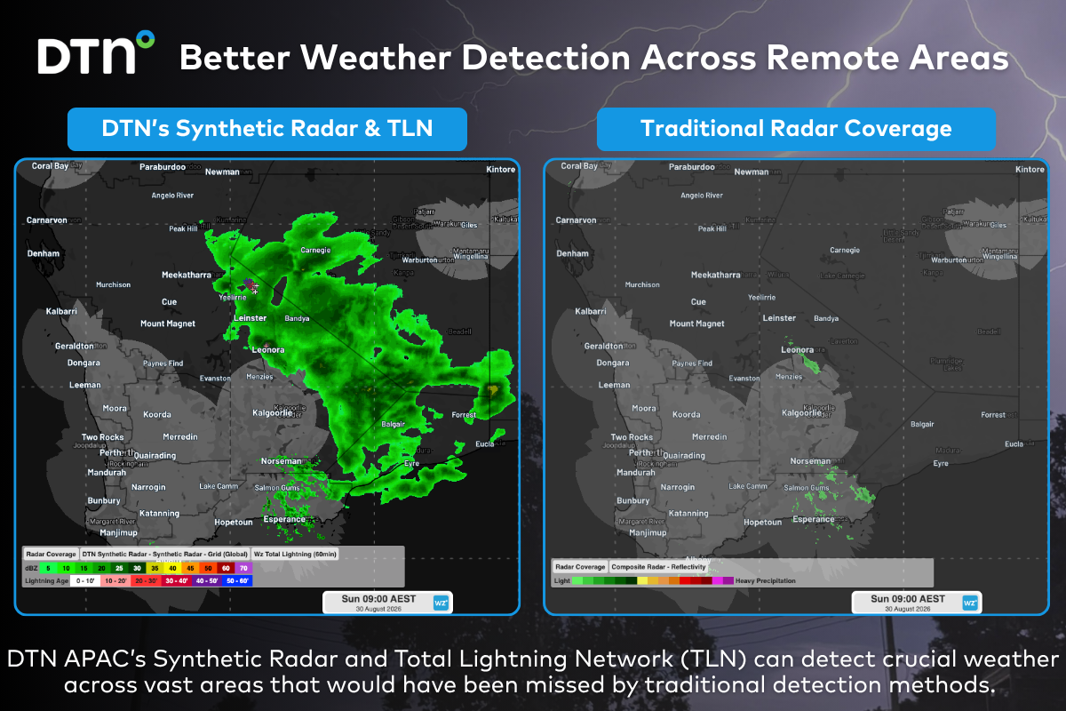
Image: Comparison of traditional radar coverage and detected rainfall (left), and DTN’s Synthetic Radar and TLN (right), across Australia at 9am AEST on Sunday, August 30, 2026.
The image on the right shows the DTN Synthetic Radar and Total Lightning Network detecting a vast area of rain and thunderstorms across remote WA that would have been missed by traditional detection methods.
DTN Synthetic Radar
High-Resolution Modelling
DTN Synthetic Radar is a satellite-derived, gridded nowcasting system. It forecasts out to 3 hours at a high spatial resolution with rapid updates. With this enhanced forecasting detail, Synthetic Radar has the upper hand over 9-12km resolution models when capturing rainfall in remote regions. This ensures that no matter where you are in Australia, you will have access to precision nowcasting and forecasting that can rapidly inform your critical business decisions.
Greater Situational Awareness
Working in conjunction with DTN APAC Stormtracker GIS system, Synthetic Radar provides full situational awareness of any severe weather event that presents risk to your business. Short-term forecasting and severe weather alerts enable you to foresee the intensity and duration of events, so you can prioritise the safety and preparation of your staff and assets.
Whatever the weather, we provide the insights to help keep you and your team safe, productive and profitable.
DTN Total Lightning Network
Our Total Lightning Network is the intelligent lightning solution that goes above and beyond to alert lightning and increase your lead time before the storm hits.
We utilise a vast global sensor network, created with our partner Earth Networks. Over 1200 sensors in 40+ countries provide a worldwide view of both intra-cloud (IC) and cloud-to-ground (CG) lightning strikes, enabling businesses to plan and respond with the most precise insight available. Our system can detect and calculate strike locations with incredible accuracy, offering real-time lightning mapping for a comprehensive view of storm activity.
Offering unsurpassed accuracy, with real-time sensing to <200m, we integrate with your existing systems to keep your enterprise operating within your defined severe weather thresholds. Our technology also helps monitor radiation from electrical discharges and ensures every lightning flash is accounted for.
Leave nothing to chance. Be confident working outdoors with the most sophisticated lightning alerting system, delivering intelligence to any device across your business network. Whether you need a personal lightning alerting tool for individual safety or enterprise-wide monitoring, our solution is designed to emit timely alerts and protect your operations.
Learn more about our large range of industry leading products and services or email us at sales.apac@dtn.com




