

Fire agencies, land managers and businesses are being urged to prepare as the AFAC spring seasonal bushfire outlook, released on August 19, 2026, warns of elevated bushfire risk across Australia this season.
The outlook identifies above-average fire danger across seven states and territories, with conditions driven by a combination of elevated fuel loads, an El Niño event declared by the Bureau of Meteorology in June 2026, and rainfall deficiencies persisting across multiple regions.
Why spring is an active time of year for fires in Australia
Spring is typically a time of year when northern Australia is in the peak of its fire season, while conditions are also becoming more conducive to fires in Australia’s central latitudes and in some parts of southern Australia.
This southward progression of fire danger during spring occurs as temperatures rise across the country, while vegetation that dried out in winter and early spring increases fire fuel loads outside the tropics.
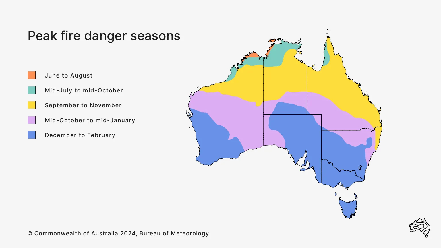
Image: Peak fire seasons in Australia. Source: Bureau of Meteorology.
What can we expect this spring?
Spring 2026 will be influenced by a very strong El Niño in the tropical Pacific Ocean – a climate driver that typically promotes abnormally warm and dry weather over large areas of Australia during spring. Above average sea surface temperatures surrounding most of Australia will also influence rain and storm potential throughout the season.
According to the Australian and New Zealand Council for fire and emergency services (AFAC), there will be an increased risk of bushfires in southeastern NSW, southeast Queensland, northeastern Tasmania, parts of WA, SA and Victoria, and large parts of the NT this spring.
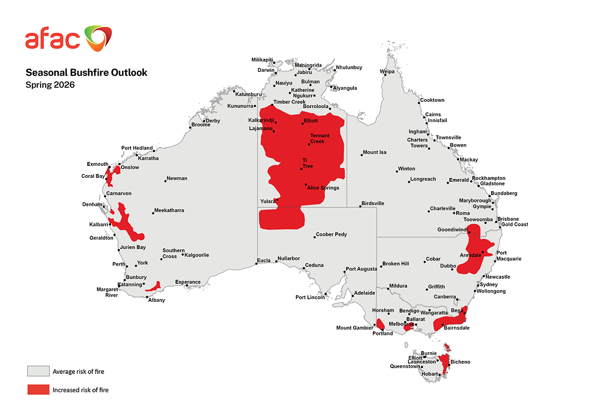
Image: Spring 2026 bushfire outlook. Red areas on the map have an increased risk of fires this spring, while the rest of the map has an average risk of fires for this time of year. Source: AFAC.
Eastern and southeastern Australia
A broad area of northeast NSW and southern Qld experienced a drier and warmer than average start to 2026. During the 7-month period from January to July, rainfall was in the lowest 10% of historical records for inland areas of southern Qld and northeast NSW. This caused a depletion in root-zone soil moisture, which has enhanced evaporation stress and contributed to increased curing (the drying out of vegetation) and fuel availability heading into the start of spring.
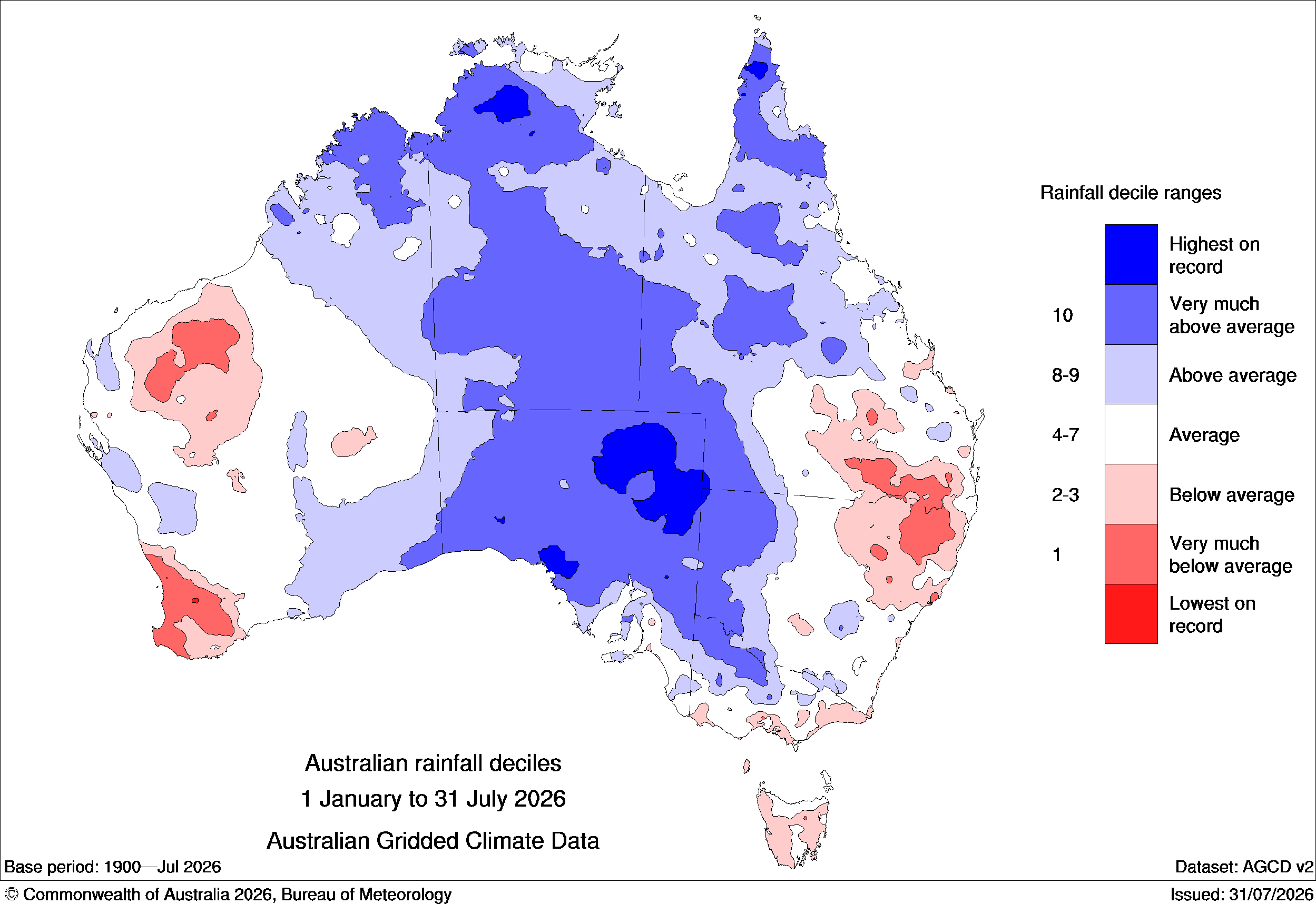
Image: Observed rainfall deciles during the first seven months of 2026. Source: Bureau of Meteorology.
The last few months have also been abnormally dry in southeast NSW and parts of eastern Vic, resulting in very much below-average root zone soil moisture (lowest 10% of historical records).
In addition to this dryness, temperatures were also above average across large areas of Australia in the last three months, with a broad area of southeastern Australia registering its warmest May-to-July period on record.
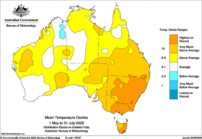
Image: Mean temperature deciles for the three month period from May to July 2026. Source: Bureau of Meteorology.
According to the Bureau of Meteorology, this spring is likely to be warmer and drier than average for parts of eastern and southeastern Australia, with ongoing root zone soil moisture deficiencies likely to persist across these regions.
This outlook suggests that parts of eastern and southeastern Australia will experience ongoing drying of fuel loads in the coming months, which should be enhanced by above-average temperatures and below-average rainfall in some areas.
The AFAC outlook highlights southern inland Qld, northern inland NSW, southeast NSW, parts of southern and eastern Vic and northeast Tas as areas that will have an increased risk of fires this spring.
Central Australia
A broad area of central Australia is forecast to have an increased risk of fires in the next few months, extending over parts of SA and up through the NT as far north as the Barkly and Gregory districts.
In the north, this elevated fire risk is due to the Top End fire season likely extending longer than usual due to a delayed wet season onset. Further south, an abundance of drying vegetation following above-average rain earlier this year is expected to supply ample fuel for fires in the coming months.
According to the AFAC, “fire activity is likely to contract southwards from November, with the Barkly and Tanami districts entering their peak fire danger period in October and November.”
“Across Central Australia, above average temperatures and extensive long-unburnt fuels in the Simpson Desert region towards the NT, Queensland and SA borders are expected to support above average fire potential from September.”
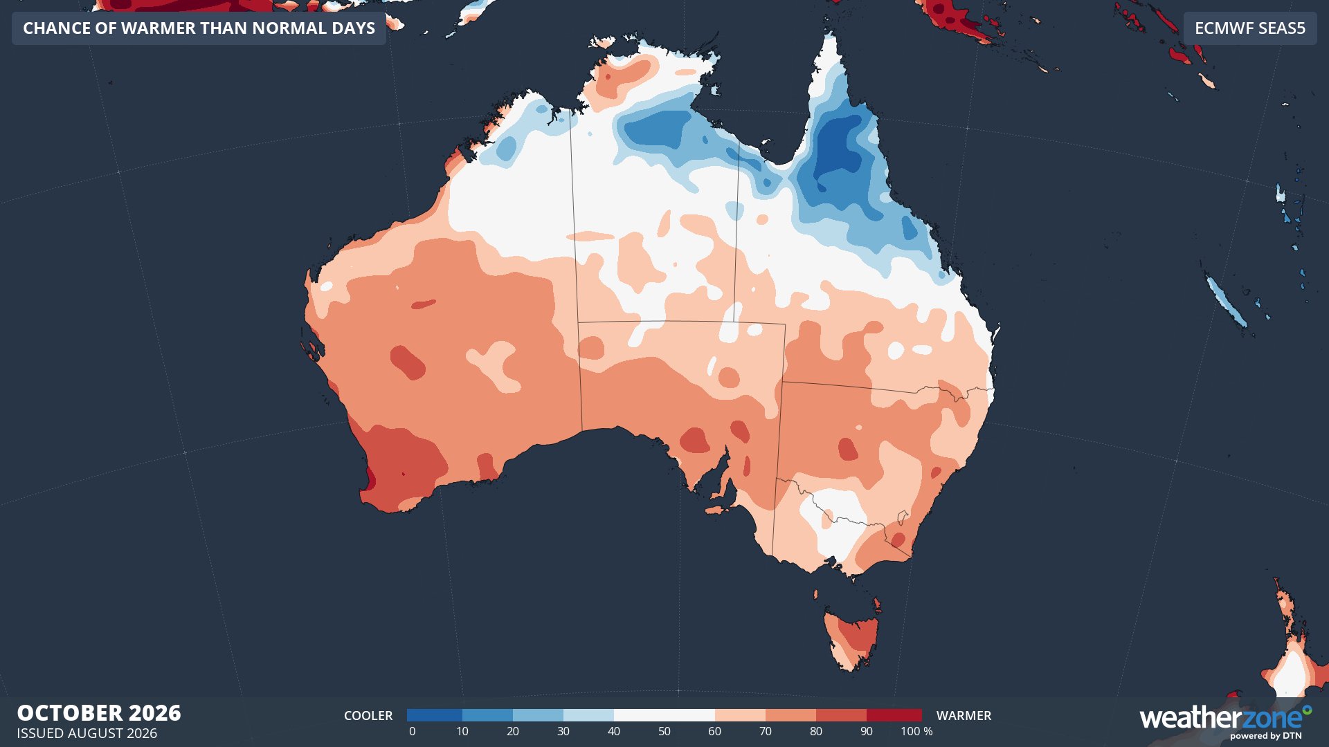
Image: Chance of exceeding median maximum temperature during October 2026, according to the ECMWF SEAS5 model. Source: Weatherzone.
Western Australia
Pockets of WA are expected to have an increased risk of fires this spring, primarily due to above average fuel loads and dry soil conditions, combined with below-average spring rainfall predicted in the state’s southwest.
In the state’s northwest, the Cape Range, Wooramel, Western Murchison, Geraldton Hills, and Yalgoo bioregions are highlighted as areas that could see enhanced fire activity due to increased fuel loads associated with growth caused by rain from recent ex-tropical cyclones.
The southern Geraldton Sandplains, Swan Coastal Plain, Jarrah Forest, and Warren bioregions are also predicted to see above average fire potential in late-spring, with below-average rain expected to enhance soil moisture deficiencies towards the end of the season.
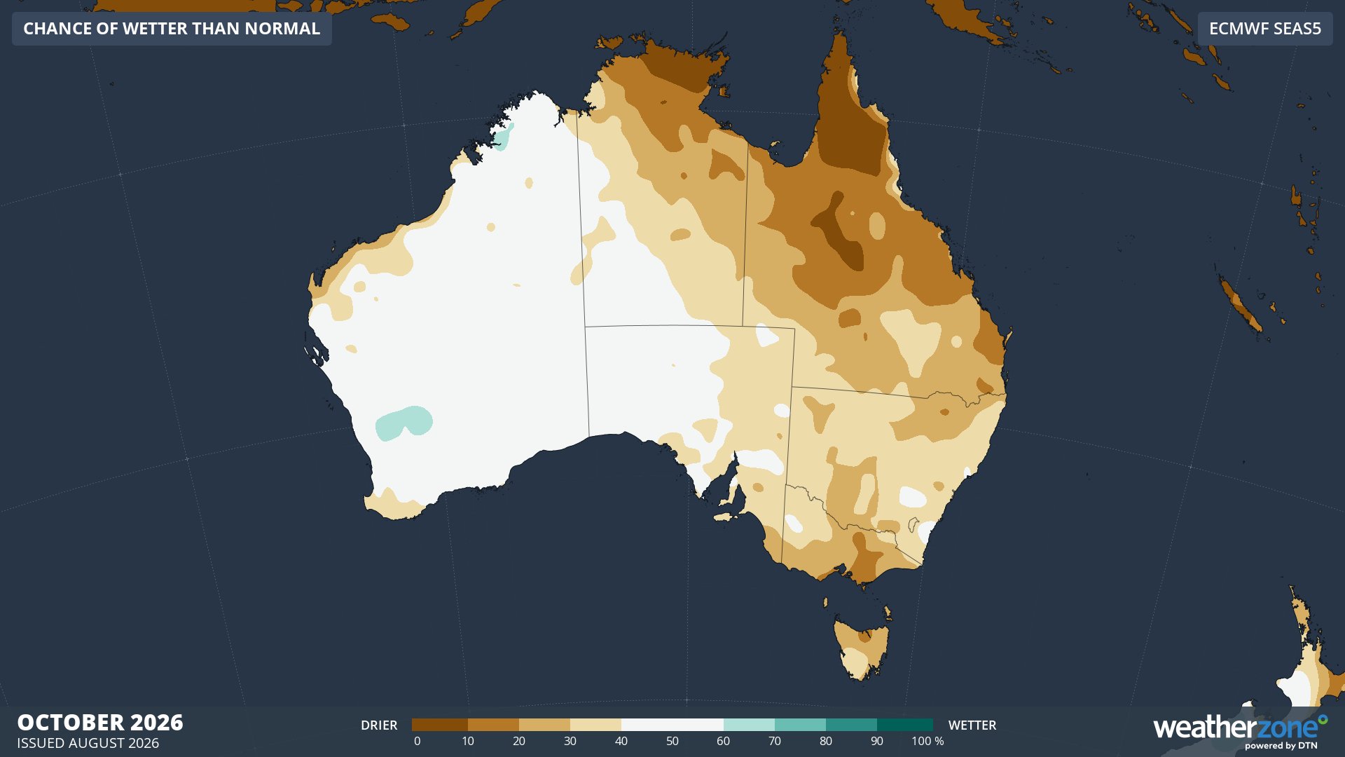
Image: Chance of exceeding median rainfall during October 2026, according to the ECMWF SEAS5 model. Source: Weatherzone.
What does ‘enhanced fire risk’ actually mean?
It is important to point out that fires can occur in any part of Australia, even in areas that are not predicted to have an increased risk of fires this spring.
The AFAC defines an increased risk of fire as: “The likelihood of an increased number of significant bushfires occurring in the outlook period compared to the average risk. Risk depends on factors including weather and climate, fuels, recent fire history, natural and human barriers, and the speed and effectiveness of fire suppression.”
Read More: Turn risk into readiness across your APAC operations ahead of the fire season
What this means for agencies and land managers
The AFAC Seasonal Bushfire Outlook reinforces what fire and land management agencies already know: weather intelligence is not optional, it is the foundation of every operational decision. From prescribed burning windows and aviation dispatch to crew pre-positioning and public warnings, the ability to act on accurate, high-resolution forecast data is what separates proactive preparedness from reactive response.
Critically, no two El Niños are the same. The true character of this season will be determined by a range of interacting climate drivers, including the Southern Annular Mode, sea surface temperatures, the Indian Ocean Dipole, the polar vortex and tropical wave patterns. The DTN APAC climate briefings translate this complexity into clear, operationally relevant guidance for agencies and land managers.
DTN APAC offers weather intelligence and fire weather solutions to support fire agencies, forestry operations, and emergency management organisations across Australia and New Zealand. Our high-resolution forecasting and decision-support tools help agencies move from awareness to action, before conditions deteriorate.




