
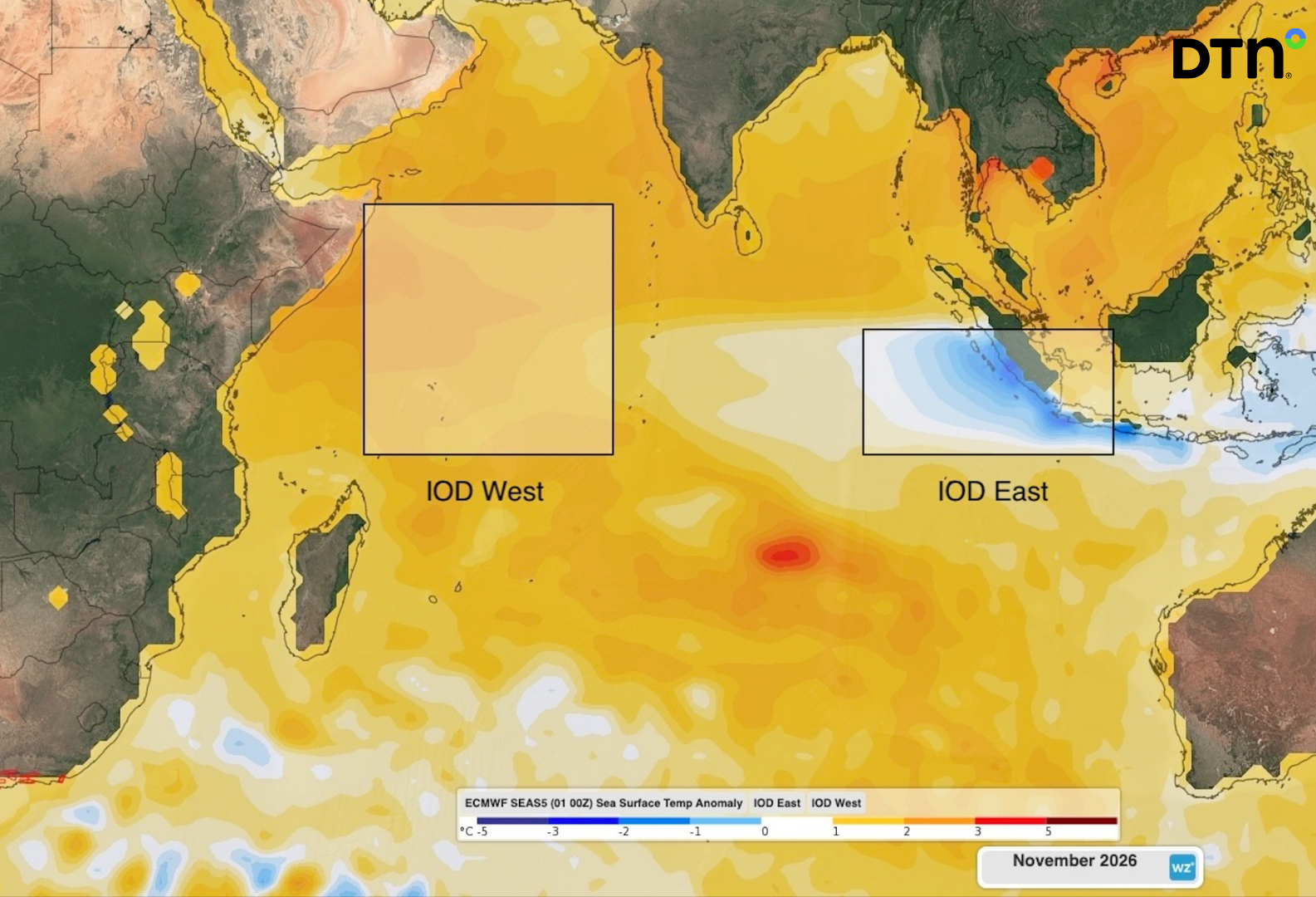
A positive Indian Ocean Dipole (IOD) could develop in the coming months, a signal mining and energy operators and fire agencies will want on their radar with it potentially increasing the likelihood of warm and dry weather over large areas of Australia in late winter and spring, with flow-on effects for water availability, dust/heat exposure, and fire danger ratings.
While a lot of attention has been paid to the strengthening El Niño in the Pacific Ocean in recent weeks, there has been less focus on the Indian Ocean. This may soon change, with forecast models predicting a positive IOD emerging in the months ahead.
What is a positive Indian Ocean Dipole?
The IOD is a climate phenomenon relating to the difference in sea surface temperatures across the tropical Indian Ocean.
Scientists measure the IOD by comparing sea surface temperatures in two defined regions: the western tropical Indian Ocean (IOD West) and the eastern tropical Indian Ocean (IOD East).
A positive IOD occurs when water on the eastern side of the tropical Indian Ocean, near Indonesia, is cooler than the water on the western side of the Indian Ocean, near the Horn of Africa.
When a positive IOD is underway, we typically see less moisture-laden air flowing across the tropical Indian Ocean towards and over Australia. This can increase maximum temperatures and reduce rainfall across large areas of the country.
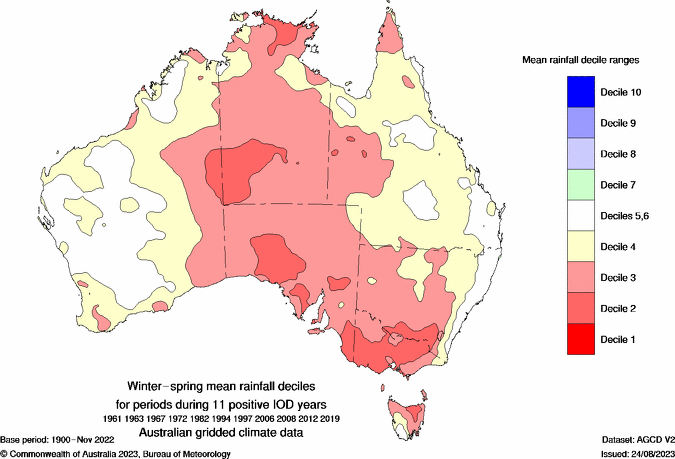
Image: Observed winter-spring rainfall deciles from 11 positive IOD events combined. The red shading shows where rainfall was below average. Source: Bureau of Meteorology.
IOD events typically begin in winter, reach a peak strength in spring and decay rapidly in early summer when the monsoon develops in the Australian region.
Signs of a positive IOD ahead
At the start of July 2026, the IOD was in a neutral phase, meaning neither a positive nor negative phase was occurring. This means sea surface temperature anomalies in the eastern and western tropical Indian Ocean are roughly equal, as seen in the image below.
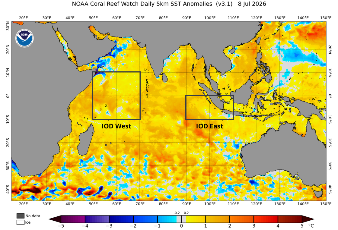
Image: Daily sea surface temperature anomalies in the Indian Ocean on July 8, 2026. Anomalies are roughly equal in the IOD West and IOD East regions, meaning the IOD is in a neutral phase. Source: NOAA.
In the months ahead, forecast models predict that sea surface temperature anomalies in the western tropical Indian Ocean will become comparably higher than the anomalies in the eastern tropical Indian Ocean. If this happens, it will set up a positive IOD pattern in late winter or spring.
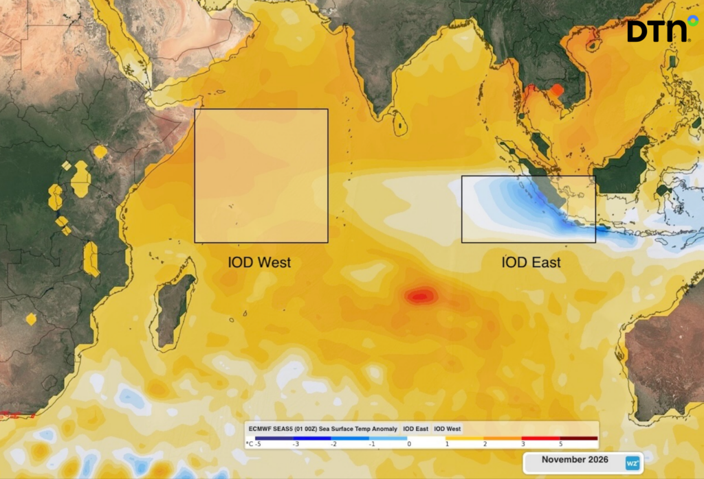
Image: Predicted monthly sea surface temperature anomalies in November 2026, according to the ECMWF SEAS5 model, showing a positive IOD pattern. Source: DTN
It is important to point out that forecast models currently have a wide range of uncertainty about the strength and timing of the IOD in the coming months.
What would a positive IOD mean for Australia’s weather?
If a positive IOD does develop this year, it will increase the likelihood of unusually dry and warm weather over much of Australia in late winter and spring.
It’s important to note that the IOD does not act in isolation, and other factors may enhance or counteract the influence of the IOD in the months ahead. For example, the IOD’s dry and warm influence will be compounded by the presence of El Niño in the Pacific Ocean. The phases of the Southern Annular Mode (SAM), which affect wind and pressure patterns across southern Australia, will also modulate the impact of the IOD in the months ahead.
Some, but not all, seasonal forecast models are already predicting below average rain and above average maximum temperatures across much of Australia by the middle of spring.
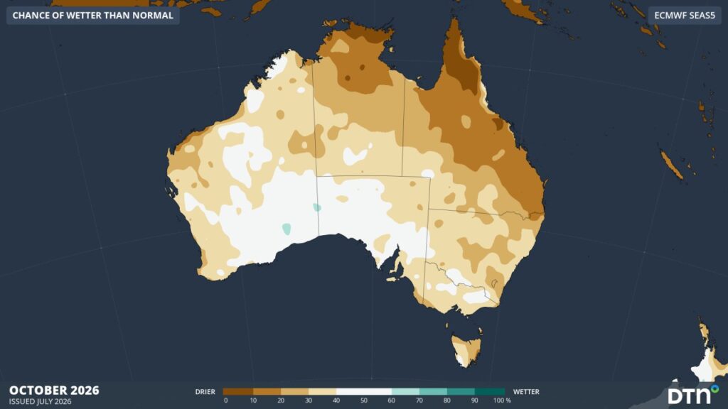
Image: Chance of above average rainfall across Australia in October 2026, according to the ECMWF SEAS5 model. Source: Weatherzone.
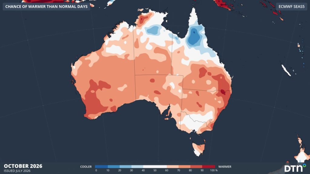
Image: Chance of above average maximum temperatures across Australia in October 2026, according to the ECMWF SEAS5 model. Source: Weatherzone.
It will be important to keep checking the latest seasonal rainfall and temperature predictions in the months ahead to see how the evolving IOD is having an impact on the forecasts.
What this means for weather-exposed businesses
Mining and Energy
Compounding warm-and-dry drivers raise the likelihood of constrained water availability for processing and dust suppression, elevated heat-stress and equipment-derating risk, and higher energy demand through summer peak periods. Understanding the timing and strength of these signals early, gives operators a longer runway to plan around water allocations, maintenance windows and demand forecasting. See our solutions for Mining, Energy and Renewables.
Government Agencies and Fire Authorities
A positive IOD combining with an El Niño could elevate fire danger risk for the 2026-27 season, which has the potential to mirror the conditions seen ahead of Australia’s driest three-month period on record in 2023 when a strong positive IOD and El Niño coincided. Earlier confidence in seasonal outlooks supports decisions on fire danger period declarations, resourcing, and public messaging well ahead of peak risk. See our solutions for Forestry & Emergency.
Despite El Niño and a Possible Positive IOD, Warm Shelf Waters Could Still Bring Wet Interruptions to Central Australia
While the waters in the IOD east region aer forecast to be cooler than average, the waters off Australia’s northwest shelf remain persistently warm, part of a broader pattern of above-average SSTs holding across most of the surrounding ocean. That warmth could fuel northwest cloud bands, which can still deliver periodic, occasionally significant rain events across central WA and into SA even in a background state that’s nominally drier and warmer overall. The net seasonal signal from El Niño and a positive IOD is toward below-average rainfall, but it doesn’t rule out episodic wet interruptions for businesses managing haul roads, tailings dams, or flood-sensitive infrastructure.
DTN APAC is monitoring the evolution of both the IOD and El Niño closely, along with these finer-scale moisture sources, and will continue to communicate what these signals mean for weather-exposed businesses as forecast confidence builds over the coming months.




