
Sydney and Brisbane just had their warmest October on record, despite a relatively cool end to the month.
A surge of cold air caused temperatures to plummet in eastern Australia earlier this week. In Brisbane, the temperature only reached 22.2°C on Tuesday, while Sydney’s maximums remained below 18°C on both Tuesday and Wednesday. These chilly days, which were about 4 to 5°C below average for this time of year, were a cold drop in an ocean of warmth this month.
Sydney and Brisbane, and many areas in between, just experienced their warmest October on record based on maximum temperatures.
Sydney’s average maximum temperature for the month came in at just under 26.6°C. This is more than 4°C above the monthly average and warmer than the previous October record of 26.2°C from 1988. This is also the second warmest spring month (September, October and November) – falling short of the record set in November 2019 of 27.0°C.
Brisbane’s average maximum temperature in October came in at around 29.4°C, more than 2°C above average and comfortably higher than the previous October record of 28.7°C from 1918.
Many other areas in Queensland and New South Wales also broke their maximum temperature records this month. This included new state records when Birdsville, Queensland reached 46.1°C and Wanaaring, NSW reached 44.9°C on October 21.
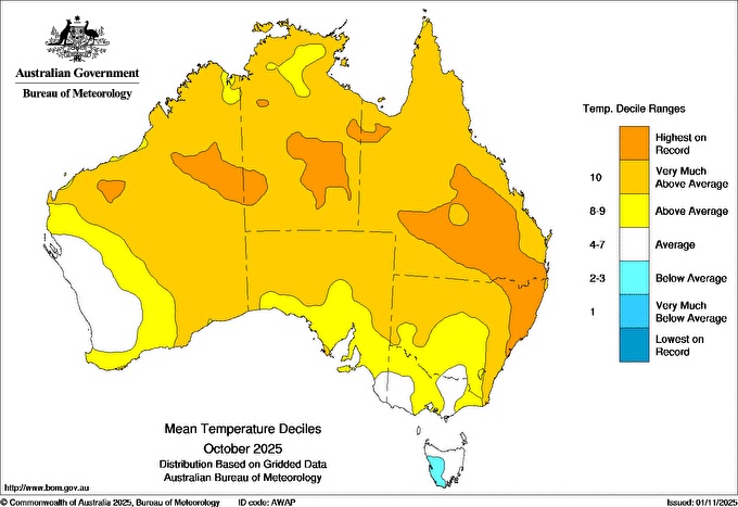
Image: Mean temperature deciles across Australia during October 2025 showing areas of NSW and Queensland with their highest October temperatures on record.
Why was October so warm in eastern Australia?
A rare sequence of stratospheric warming episodes occurred high above Antarctica in September and October. These abrupt changes in temperature disrupted the Southern Hemisphere’s polar vortex, which affected weather patterns over Australia during October.
One of the big effects from this stratospheric phenomenon was a relentless flow of warm and dry westerly winds over eastern Australia throughout most of October. These westerly winds carried hot air from central Australia across Queensland and NSW, causing weeks of unseasonably warm and dry weather.
The map below shows that air temperature around 1.5 km above the surface was, on average, about 3 to 4°C warmer than usual over a large area of central and eastern Australia.
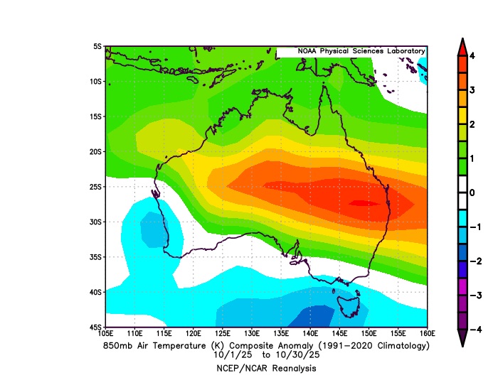
Image: Average 850 hPa temperature anomaly for the first 30 days of October 2025. Source: NOAA
Another factor that helped cause this month’s record-breaking heat was a lack of cloud and rain over large areas of the country. Despite the presence of a strong negative Indian Ocean Dipole – a climate driver than typically boosts cloud and rain over Australia in spring – northern, central and eastern Australia only saw limited rain during October. This was because of the strong influence of the stratospheric warming event, which counteracted the IOD.
Climate change is also likely to have played a role in this month’s record heat. The average maximum temperature over eastern Australia has increased by around 1.84°C since 1910.
DTN APAC has grown to become the outright leader within the Australian energy market, serving wind, solar, hydro, trading, utilities and network companies.
You can’t control the weather, but you can gain precision insights to optimise your response. What lights us up is providing your energy business with tailored weather information to reduce your risk and keep you moving ahead of the curve.
Our services cover all aspects – from wind and solar generation to demand forecasts, wholesale markets to retail so, no matter where your company sits, we have solutions for you. We have worked closely with market participants to create products that meet the evolving needs of the sector, aiming to increase safety and profitability for our customers.
Your customisable Energyzone interface can assess heat/heatwave potential from 14 days out to 12 months. It allows you to benefit from specialised indices for CDD/HDD/apparent temperature/sunshine hours to help accurately predict the demand for electricity. This, along with high-resolution modelling and local knowledge, gives you the most precise information available to make the critical decisions that bolster your production.
Benefit from the timely delivery of accurate weather information, allowing informed and effective decision-making.
How DTN APAC Risk Communicators inform your decision making with tailored weather and seasonal climate outlooks
DTN APAC is a diverse team, with global forecasting, product development and analytics expertise. Couple this with extensive industry experience spanning Aviation to Energy, and we are primed to assist you in strengthening your response to weather impact.
We work hard to identify your operational pressures and tailor our services and products to meet your needs. Concise communication, giving you full situational awareness exactly when you need it, is our focus. We want to reduce weather risk in your operations, every day.
We deliver clear and comprehensive weather data that you can’t get anywhere else, personalised risk assessments and briefings to you and your team, so that your critical decisions can be made with confidence.
We are available 365 days a year, so you always have the timely guidance you require, especially when extreme temperatures hit.
Learn more about our large range of industry leading products and services or email us at sales.apac@dtn.com




