
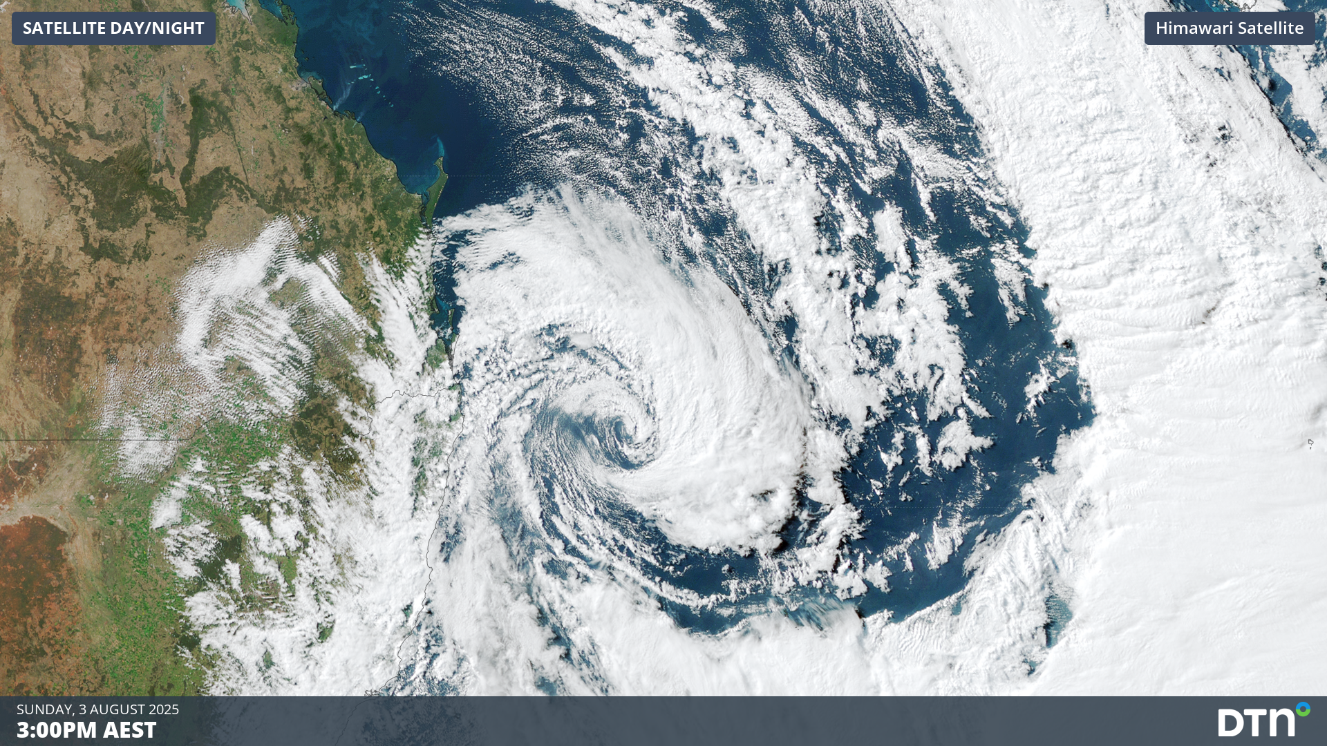
Powerful swell and intense rainfall and snow impacted eastern NSW businesses over the weekend as a vigorous low pressure system moved off the coast. Transport closures, port disruptions and emergency response services led to a busy weekend across NSW and southeast Queensland businesses.
Satellite imagery below shows the spiraling cloud of the low pressure system sitting off NSW’s north coast on Sunday.
Video: Visible satellite imagery on Sunday, August 3, 2025.
Flooding rainfall and heavy snow
A deep stream of moisture wrapping around the low brought intense and flooding rainfall to parts of eastern NSW. Since Friday, rainfall accumulations of 100-150mm have been recorded across parts of the Mid North Coast, Hunter, Sydney and Illawarra regions.
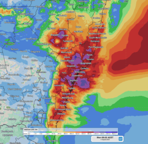
Image: DTN’s Quantitative Precipitation Estimate (QPE) of 3-day rainfall to 9am AEST on Monday, August 4, 2025.
The intense rainfall brought areas of major flooding along parts of the North West Slopes, and minor-to-moderate river flooding across parts of the Hunter and Mid North Coast, cutting off road and rail transport networks. River levels now remain near the minor level but are expected to decrease today with much less intense rainfall forecast. NSW SES conducted over 2,000 incident responses over the weekend, including 25 flood rescues.
This deep feed of moisture combined with a pool of very cold air over NSW’s Northern Tablelands, delivering heavy snowfalls. Hazardous conditions with the snow, ice and fallen trees led to road closures across the region, including over the New England Highway.
Read more about this weekend’s snowfalls: (Weatherzone) Heavy snow blankets NSW Northern Tablelands
Gales and huge waves
Gale-to-storm force winds around the low resulted in wind gusts exceeding 100 km/h at Norah Head (104 km/h) and Nobby’s Head (102 km/h) on Saturday. The strong winds combined with the heavy rainfall to topple trees and powerlines, resulting in rescue efforts and power losses.
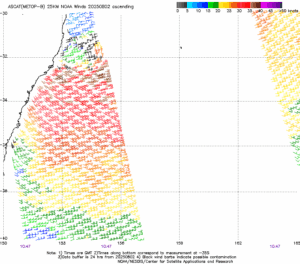
Image: ASCAT satellite imagery showing a broad area of gales directed into eastern NSW on Saturday evening, August 2, 2025. Source: NOAA
Huge swell generated by these winds is hammering the NSW coastline, with hazardous surf warnings in place for the entire NSW coastline and Gold Coast until Wednesday, and a coastal hazard warning for damaging surf in place on Monday across the coastline between NSW’s Mid North Coast and Cape Moreton in Queensland.
Wave heights reached their peak between Sunday afternoon and early Monday, reaching significant wave heights of:
- 7.8m at North Stradbroke (maximum wave height of 12.3m)
- 7m at Byron Bay (maximum wave height of 12m)
- 6.9m at Gold Coast (maximum wave height of 9.7m)
- 6.6m at Tweed Head (maximum wave height of 10.0m)
- 6.6m at Coffs Harbour (maximum wave height of 11.6m)
- 6.2m at Crowdy Head (maximum wave height of 12.6m)
- 5.2m at Sydney (maximum wave height of 10.7m)
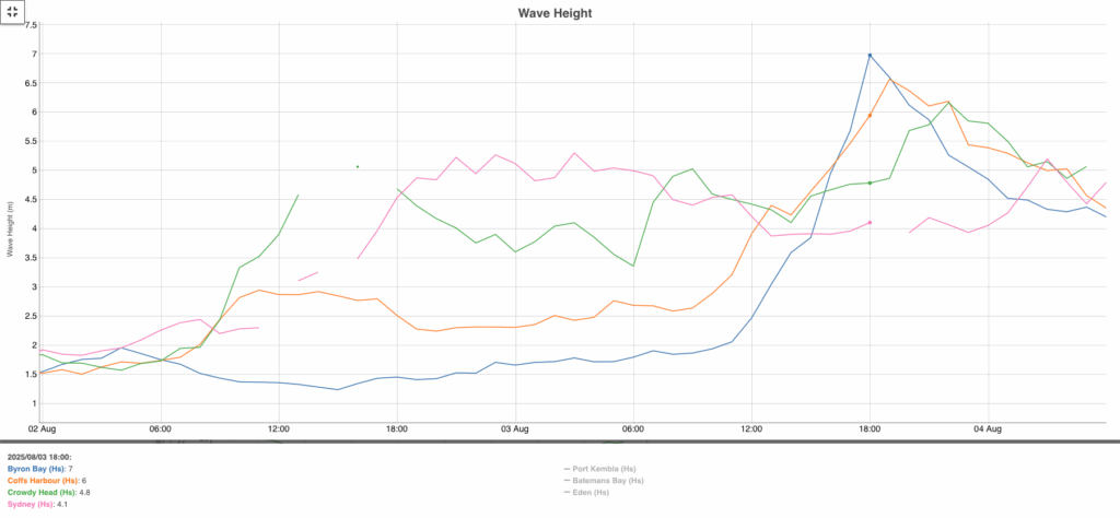
Image: Observed significant wave heights at Byron Bay, Coffs Harbour, Crowdy Head and Sydney from Saturday, August 2, 2025 to Monday morning, August 4, 2025. Source: Manly Hydraulics Laboratory
According to Manly Hydraulics Laboratory, the operator of numerous Surfrider buoys across NSW, Byron Bay’s and Crowdy Head’s peak significant wave heights are the highest recorded in August on record (50 and 40 years of records, respectively). The occurrence probability of these wave heights is also less than a 0.01% chance at any time of the year.
The low responsible for these strong winds and huge waves is now moving east, away from the mainland. However, swell heights will only slowly decrease into mid-week, with a persistent area of easterly gales maintaining a lengthy period of swell generation directed towards NSW and southeast Queensland.
How DTN APAC assists marine, ports and offshore industries
DTN APAC offers a comprehensive suite of services, refined through years of collaboration with the marine, ports and offshore industries, to optimise the safety and efficiency of your operations.
We work with you to understand your intrinsic operational challenges and customise high-precision forecasting, metocean and aviation services to your exact location and operational scope.
When working offshore, our solutions can underpin planning and safe execution for offshore oil and gas enterprises and wind farms. Our data can support your exploration, development, rig moving, shuttle tanker operations, and production and decommissioning phases. Whether your crews are on-site, being transported to shore, or diving to perform maintenance, we deliver tailored weather risk briefings to ensure you choose the optimal time to proceed.
DTN APAC’s trusted nowcasting and forecasting system, OpticastTM, allows you to rapidly respond to changing conditions offshore, en route and in port. We take your port topography and berth orientation into account, ensuring site-specific forecasts. For offshore oil & gas, wind farms, ports and logistics, we have your weather situational awareness covered, no matter where you are. We deliver real-time severe weather and lightning alerts to your team via your integrated dashboard: Portzone, and our Weatherguard app.
DTN APAC’s Total Lightning Network (TLN) ensures you avoid hours of unnecessary downtime by providing the most accurate technology in lightning detection and alerting. Safeguard your teams and assets with lighting and Dangerous Thunderstorm Alerts (DTAs), customised to your existing parameters and delivered in real-time across all devices in your network. You gain full spatial awareness of developing severe weather systems, allowing you to plan ahead and, where needed, execute your shutdown and evacuation procedures.
With extreme conditions slowing production and affecting infrastructure, safety and transport, trust us to deliver Australia’s most precise weather data and tailored insights, giving you decisive confidence when it’s most needed.
Learn more about our large range of industry leading products and services or email us at sales.apac@dtn.com




