The East Coast Low lashed large parts of the NSW coastline in the 24 hours to Wednesday morning as damaging to destructive winds, intense rainfall and large waves disrupted industries from aviation to ports, and transport to power utilities.
The stretch of NSW coastline from the Hunter region to the South Coast has been most severely affected, with more than 30,000 customers without power and numerous homes evacuated due to coastal erosion and/or flooding.
East Coast Lows are one of the most dangerous types of weather systems in Australia. Their impacts can be similar to a category 1 or 2 tropical cyclone and they often affect highly populated areas of Australia’s eastern seaboard.
This week’s system formed when an upper-level trough passing over NSW caused a surface-based low pressure system to deepen rapidly near the NSW coast.
The video of satellite imagery below shows a broad area of cloud within a coastal trough on Monday rapidly intensifying into an East Coast Low on Tuesday and Wednesday near eastern NSW.
Video: Satellite images showing an East Coast Low forming near the NSW coast between Monday, June 30, and Wednesday, July 2, 2025.
The intense low pressure system sat very close to the NSW coast throughout Tuesday and into Wednesday, causing a sustained period of heavy rain, flooding, damaging to destructive winds and damaging surf over a broad area of eastern NSW.
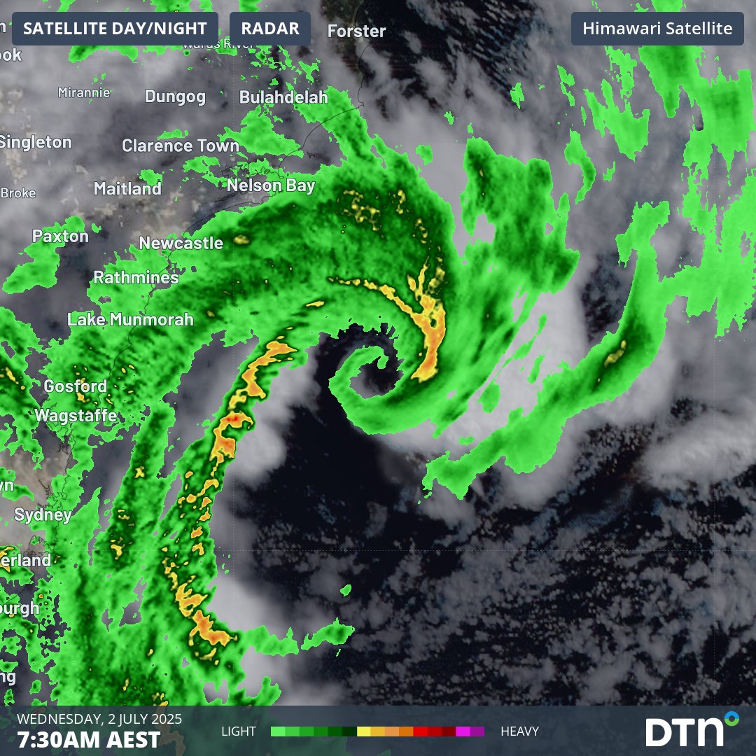
The intensity of the storm can be seen on the radar, with bands of rain spiralling towards the centre of the low which was located approximately 65 km southeast of Seal Rocks around 9am.
Image: Three-hour combined radar and satellite loop for the central NSW coastline on the morning of Wednesday, July 2, 2025.
The severe weather from this system caused power outages and evacuations as wind gusts reached 130 km/h along the coast and rain rates exceeded 120 mm in 6 hours and 220 mm in 24 hours.
Heavy rainfall totals lead to evacuation orders
Some of the heaviest 24-hour rainfall totals in years have been recorded on the NSW South Coast, with widespread heavy falls. Numerous locations received more than 200mm in the 24 hours to 9am Wednesday. Notable totals included:
- 224mm at Ulladulla, which followed 40.2mm the previous day. That’s a running storm total of 264.2mm.
- 217mm at Fitzroy Falls Dam on the NSW Southern Highlands.
- 207mm at Bawley Point Rd.
- 143.6mm at Moruya Airport.
Widespread falls exceeding 50mm across the Sydney basin with both the city and the airport topping 70mm.
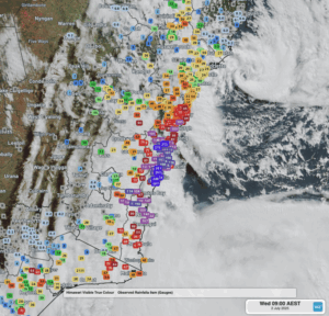
Image: Rainfall observations in the vicinity of the low pressure system for the 24 hours to 9am on Wednesday, July 2, 2025, as depicted on the DTN APAC Stormtracker Dashboard.
With the intense rainfall experienced across parts of the South Coast and Illawarra, emergency services have issued evacuation orders displacing people and disrupting local businesses.
Damaging to destructive wind gusts
Numerous wind gusts exceeding 100 km/h have been recorded over the past 24-48 hours, with the strongest gusts in the early hours of Wednesday. These included:
- 130 km/h gust at Wattamolla at 5:39am, the strongest in more than a decade at that location in the Royal National Park just south of Sydney.
- 117 km/h gust at Port Botany (Molineux Point) at 5:50am
- 104 km/h gust at Ulladulla at 7:21pm Tuesday, the strongest gust in five years.
- 104 km/h gust at Penrith Lakes on Tuesday evening, the strongest gust there in 12 years.
- 104 km/h gust at Montague Island at 3:30am.
- 102 km/h gust at Sydney Harbour at 5:43am, the strongest in nearly eight years.
- 102 km/h gust at Bellambi at 4:37am
- 100 km/h gust at Ulladulla at 5:43am.
- 100 km/h gust at Kiama at 5:58am.
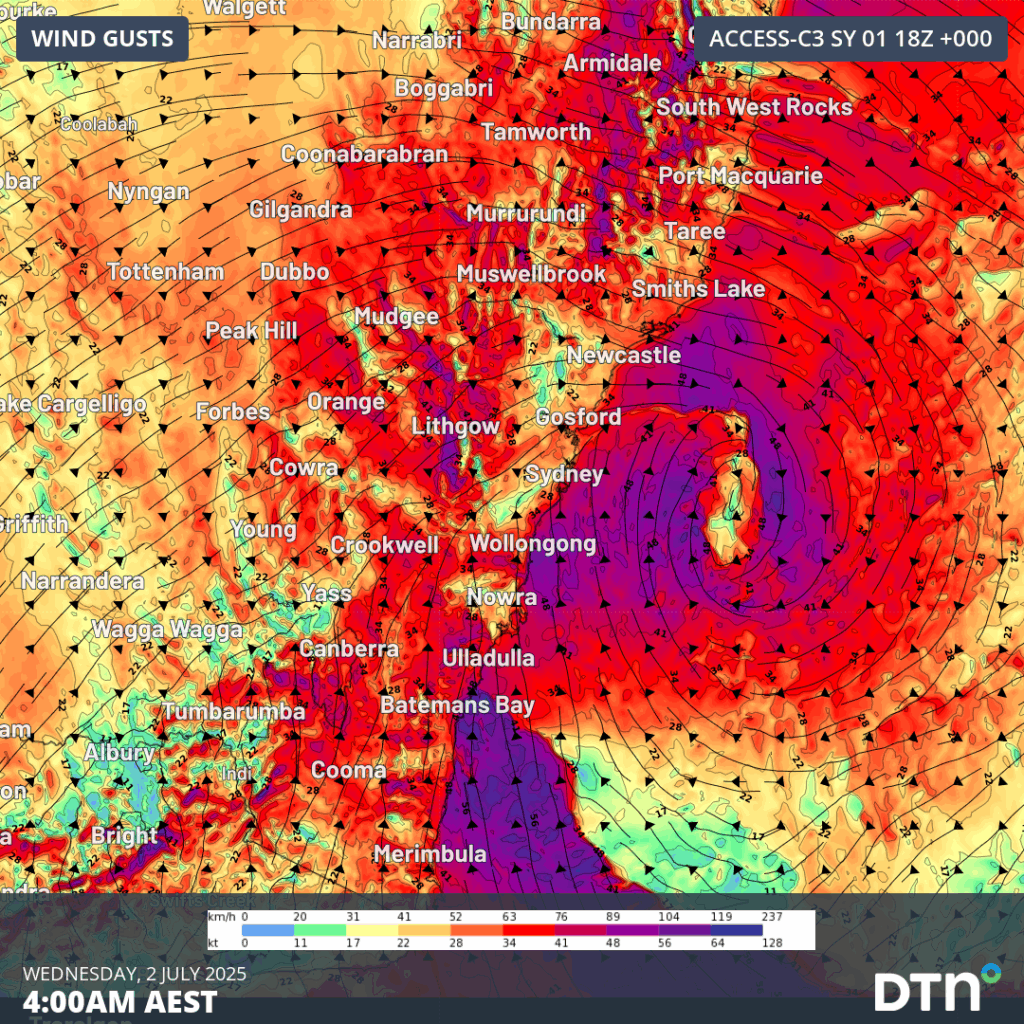
Image: NSW wind gusts at 4am on Wednesday July 2, 2025, which was around the time some of the strongest gusts were recorded.
Combined with the heavy rainfalls, toppled trees have brought train lines to a halt, caused road and transport accidents, and lead to significant losses of power across electrical networks.
Huge waves disrupt port operations
Huge swells have been whipped up by this intense low pressure system, whose central pressure dropped 26 hectopascals within 24 hours to 988hPa from Monday into Tuesday.
- Sydney’s Botany Bay registered a significant wave height (the average height of the highest third of waves) of 6.5m and a maximum wave height of 10.6m at 4pm Tuesday.
- Port Kembla registered a significant wave height of 6.4m and a maximum wave height of 13m.
- Batemans Bay registered a 12.3m maximum wave height around midnight.
- The buoy off Eden, the southernmost major town on the NSW coast, recorded registered a maximum wave height of 12m at 3am Wednesday.
Significant wave heights above 6m have an occurrence probability of only 0.03% at Port Kembla, Batemans Bay and Eden (up to 0.07% for Sydney), making this a rare and significant coastal event. Large swells will gradually abate over the coming days, but will still likely remain large enough to disrupt port operations.
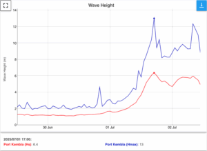
Image: Wave heights at Port Kembla on from June 30 to July 2. Source: Manly Hydraulics Laboratory.
What’s next?
Fortunately, the low pressure system that caused the severe weather on Tuesday and Wednesday will move towards the east into Wednesday night, taking it away from the coast. However, a second low pressure system associated with the same broad low pressure complex will deliver another burst of wind and rain to eastern NSW on Wednesday night into Thursday morning.
The weather will improve by Friday as the lows move further away from the coast and a high pressure ridge build over eastern NSW.
How DTN APAC Risk Communicators are supporting businesses through this East Coast Low
From Transport to Utilities, and Ports to Offshore energy farms, our Risk Communicators can help your business across Australia and New South Wales plan ahead and make confidence decisions when severe weather impacts.
Our Risk Communicators work closely with you to analyse how weather impacts your operations and communicate potential risks. We can then support your risk management planning, and provide situational awareness and post-event reporting when extreme weather events hit hard.
DTN APAC, is a diverse team, with global forecasting, product development and analytics expertise. Couple this with extensive industry experience spanning Aviation to Energy, and we are primed to assist you in strengthening your operational strategies when responding to weather disruption.
We consult with you to understand the nuances of your operations and your existing procedures and policies. We can then assist in creating communication structures, safety strategies and procedures to mitigate the risks that may impact your workforce, assets and uptime.
Our Risk Communicators are working closely with industries and businesses likely to be affected by this week’s East Coast Low, in order to mitigate the risk of damaging and long lasting impacts. Our weather risk communicators deliver short- to long- term guidance from:
- hourly-event weather monitoring (assisting you when severe weather is about to hits and is likely to clear).
- week to month operational planning based on likely timing of increased rain or low pressure development.
- seasonal long term planning based on climate drivers and the likely trends across the coming months.
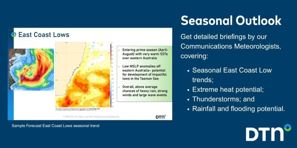
As seen below, long range forecasts provided by our weather risk communicators at the start of autumn signaled for increased activity in the Tasman Sea over the coming autumn and winter.
We deliver clear and comprehensive weather data that you can’t get anywhere else, personalised risk assessments and briefings to you and your team, so that your critical decisions can be made with confidence.
We are available 365 days a year, so you always have the timely guidance you require, especially when severe conditions hit.
You have our insights to rely on to see you through complex situations, minimising potential loss of profit and maximising the safety of your staff and assets.
Learn more about our large range of industry leading products and services or email us at sales.apac@dtn.com


