Perth just registered its wettest day since July last year and more rain is in the way for Australia’s west coast in the coming days.
The first five months of 2025 were unusually dry in Perth. The city only received 96 mm of its 170 mm average for the period from the start of January to the end of May.
This lack of early-year rainfall was partially caused by a predominantly positive Southern Annular Mode (SAM) between March and May. When the SAM is in a positive phase at this time of year, it can prevent rain-bearing cold fronts from reaching southwestern Australia.
What is the Southern Annular Mode (SAM)?
The Southern Annular Mode (SAM) is an index used to monitor the position of the westerly winds that flow from west to east between Australia and Antarctica. When the SAM is in a negative phase, these westerly winds, and the cold fronts and low pressure systems they carry, are located further north than usual for that time of year. When the SAM is positive, the westerly winds, cold fronts and low pressure systems are located further south than usual.
The start of June has seen a transition towards a more negative SAM, which has ushered in a more winter-like processions of cold air and rain over the southwest of Australia.
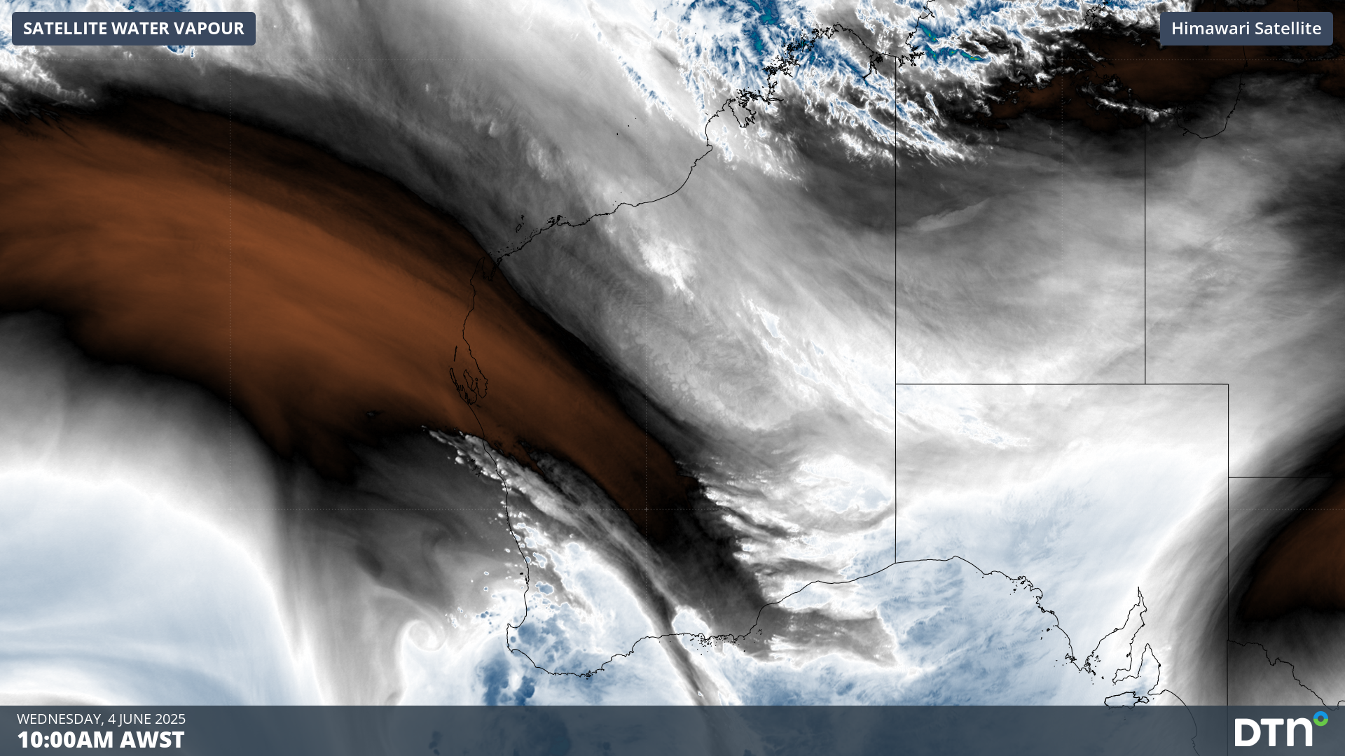
Image: Cloud and showers streaming over the southwest of WA on Wednesday morning.
Perth picked up 47.6 mm of rain during the 48 hours ending at 9am AWST on Wednesday, with 33.2 mm falling in the final 24 hours of this period. This was the city’s wettest day in 11 months. Bickley’s 41 mm in the 24 hours to 9am on Wednesday was also its heaviest daily rain in nine months.
Rain, thunderstorms and blustery winds will continue over a broad area of WA on Wednesday as a low pressure system and associated low pressure troughs affect the state. This wet and windy weather will ease on Thursday and Friday as a high pressure ridge builds over WA.
This week’s burst of rain and wind is a reminder that winter has arrived, and Perth and WA industries can expect to see more systems like this in the coming weeks and months. Forecast models already suggest that another front could hit the southwest of WA early next week.
Video: the DTN Total Lightning Network, radar and satellite imagery in action on Wednesday, June 4, 2025.
As of 10am AWST on Wednesday, June 4, the DTN Total Lighting Network has detected nearly 250,000 lighting strikes within 400km of Perth since the start of the week.
How DTN APAC’s Stormtracker can help your business
Embedded in DTN APAC’s industry interfaces, the system gives you a time advantage when monitoring conditions developing over your infrastructure and location.
Stormtracker is our Global Information System (GIS) tracking tool, providing multiple weather layers and zoom controls overlaid on a map of your location and infrastructure. You can choose a snapshot or full screen view, depending on your requirements. The maps allow you to monitor all weather, and specifically any systems likely to cause risk for your business. You also have the capacity to observe:
- real time lightning and thunderstorm alerts
- localised lightning strike frequency
- official warnings for storm, cyclone, wind, flood and fire
- sentinel hotspot fires and fire agency current incidents
![]()
Image: the DTN APAC Stormtracker in action, with TITAN Tracks and the Total Lightning Network monitoring each storm cell moving into the Perth region on Tuesday, June 3, 2025.
Stormtracker’s radar imagery updates every 5 minutes, so you are always able to respond rapidly to changing conditions. You can customise alerting to notify you when your staff or infrastructure are under threat. With increased situational awareness, your ability to make informed decisions quickly is optimised.
DTN APAC’ experience and intelligence gives you a clear path through complex situations. Let us assist you, offering actionable insight when extreme weather poses risk to your business.
Learn more about our large range of industry leading products and services or email us at sales.apac@dtn.com


