

Nearly all of Thailand’s airports either have single or parallel runways, so how do monsoonal bursts affect the airport operations and why do they rarely need cross runways?
Like most countries in the tropics, a seasonal reversal in the winds occurs with the shift in the monsoon. This makes infrastructure planning during an airport’s construction much more straightforward than in the globe’s more temperate climates.
The map below outlines the locations and orientations of Thailand’s two Bangkok airports and the single runway airport of the major tourist hub of Phuket. The capital city’s airport runways have a mostly north-south orientation, while Phuket has a mostly east-west orientation.
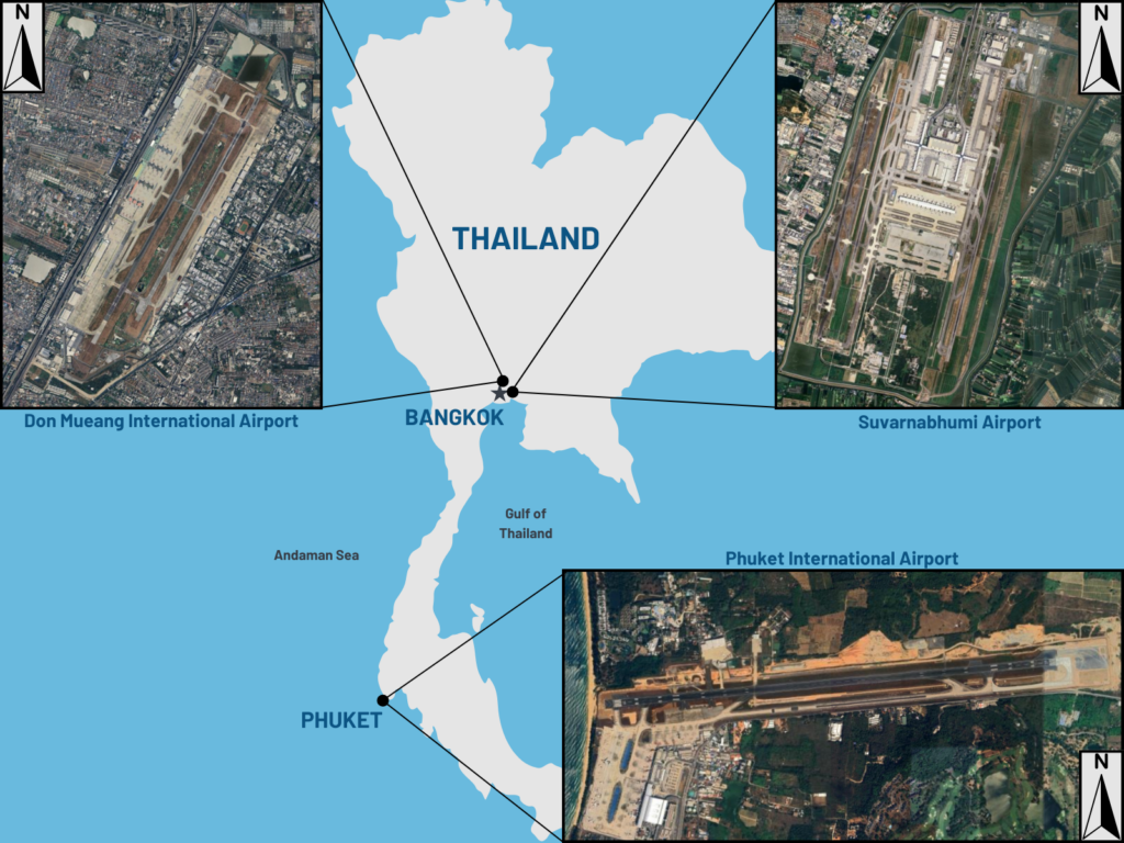
Annotated image: Map of Thailand with location of Bangkok and Phuket’s airports.
Bangkok
The bustling airports of Bangkok see the most dominant winds come from the Gulf of Thailand in the form of the southwest monsoon and the daily seabreeze effect, with the remainder of Indochina to the north mostly blocking the northeast monsoon. The heaviest rainfall comes during the southwest monsoon in northern hemisphere summer, leading to disruptive flooding.
The image below shows that the prevailing wind direction at Bangkok airport comes from either the northeast or south-southwest, depending on time of year. Bangkok’s two parallel runways are orientated to the north-northeast and south-southwest, ensuring the airport rarely encounters crosswinds.
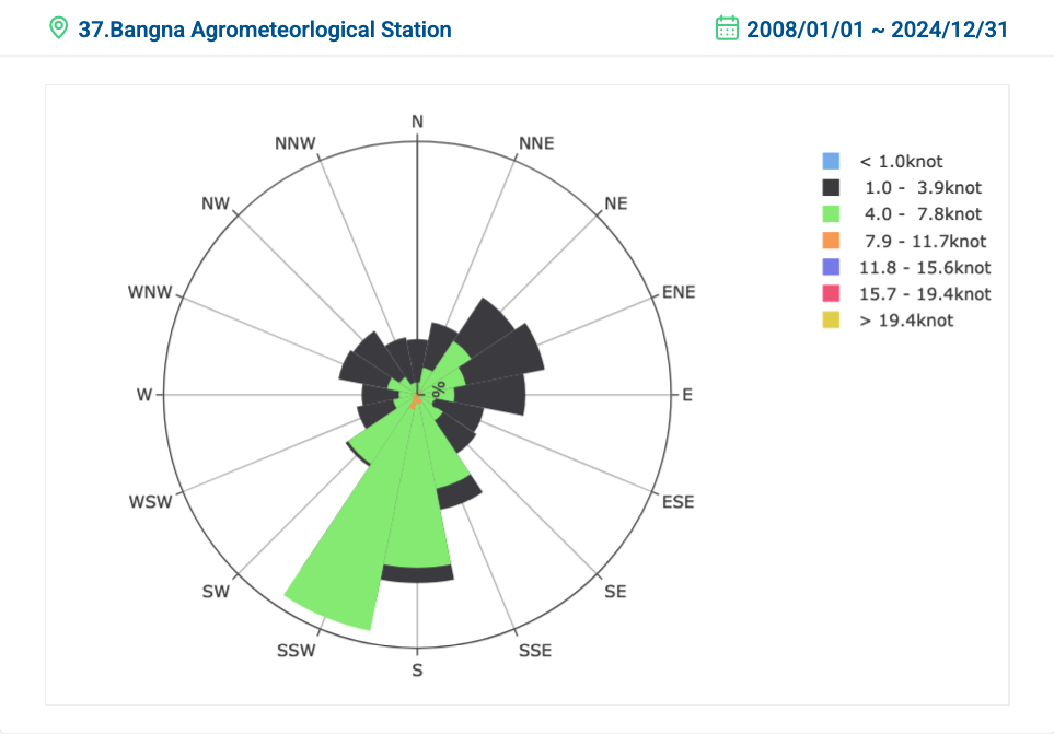
Figure: Wind roses from Bangna Agrometeorlogical Station in the Bangkok region showing the wind direction (compass direction), strength (various colours) and frequency (size of each rose petal) between 2008 and 2024. (Thai Meteorological Department)
Crosswinds, or winds blowing perpendicular to a runway, can significantly impact aircraft operations, particularly during landing and takeoff, causing pilots to lose control and potentially leading to accidents.
Phuket airport
In Phuket, the southwest monsoon is strongest coming in from the Bay of Bengal and Andaman Sea, with the northeast monsoon slowing down over the Malay Peninsula to the east. While showers are possible throughout the year, the most intense rainfall occurs during the southwest monsoon, with winds blowing off the very warm waters to the west.
The image below shows that in Phuket the prevailing winds come from the east and west, dependent on the monsoon. The orientation of Phuket airport also means that crosswinds are rare, ensuring smooth operations at this airport.
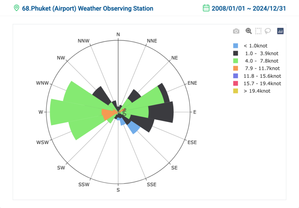
Figure: Wind rose from Phuket (Airport) Weather Observing Station showing the wind direction, strength and frequency climate between 2008 and 2024. (Thai Meteorological Department)
Runways are orientated into the prevailing winds, limiting the effects of cross winds and any costly delays that these can cause. Airplanes can use head or tail winds to assist in landing and taking off, whereas cross winds are much harder to operate under.
Surge in the northeast Monsoon coming next week
A surge of cold air coming from Siberia and northern China will sweep into East Asia over the coming days. This will send a burst of northeasterly winds down the South China Sea, turning into the Gulf of Thailand early next week.
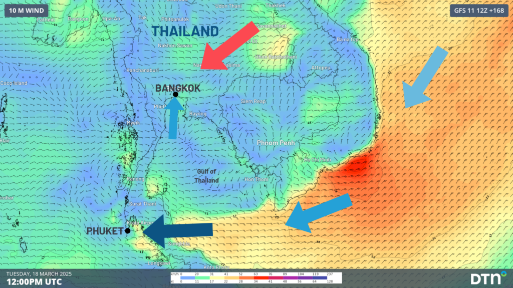
Image: Surge of east to northeast winds coming from the South China Sea into the Gulf of Thailand next week.
While airport disruptions due to wind are unlikely due to the well-planned runway orientations, some heavier rainfall and thunderstorms could move over parts of Thailand. The Bangkok area could see a thunderstorm or two move over the city on Sunday and/or Monday as the drier northeasterly winds crossing over the Annamite Ranges of Laos and Vietnam battle the moister seabreeze. Drier and sunny conditions are expected later next week across Bangkok with these dry winds persisting. In Phuket, the surge of easterly winds will pick up moisture over the Gulf of Thailand before crossing the Malay Peninsula, bringing periodic showers and thunderstorms, most likely between Monday and Friday next week.
How DTN APAC can help
DTN APAC delivers a proven aviation weather briefing system, developed in collaboration with the industry, to keep your enterprise performing at peak efficiency.
We meticulously tailor actionable weather intelligence to suit the scope of your company’s work, on the ground and in the air. Accurate and comprehensive international data informs your daily decisions on safety, fuel loads and staffing.
Working alongside our global network of partners and suppliers we collate the data to give you full situational awareness of both en route and port specific conditions. DTN APAC is accredited and adheres to standards for aviation meteorology set by the World Meteorological Organisation (WMO) and the International Civil Aviation Organisation (ICAO). Registered with the ICAO and providing safety critical OPTMET data with permission from Air Services Australia, our aviation services meet the industry’s stringent requirements.
This is weather intelligence delivered in an easy to visualise format. No matter what the weather has in store, we give you clear foresight to make informed decisions.
To find out more about our large range of products and services contact us at sales.apac@dtn.com
Thumbnail image: iStock/Surachart Sukhum




