
Two tropical cyclones could form in the Australian region by the start of next week, one in the Coral Sea and the other off the north coast of WA. Our team of meteorologists have been helping our clients assess the potential risks to their businesses in the coming week.
It has been one week since Severe Tropical Cyclone Zelia made landfall to the east of Port Hedland in WA’s Pilbara region. That powerful cyclone dumped hundreds of millimetres of rain and caused widespread flooding after crossing the coast as a high-end category four system last Friday.
Now, two other areas of low pressure near northern Australia are being watched closely by meteorologists because they both have a high risk of becoming tropical cyclones in the coming days.

Image: Enhanced infrared satellite images showing cloud building around two developing tropical lows near Australia, one off the north coast of WA and the other near northern Qld.
One of the tropical lows is located to the north of WA and has been showing clear signs of rotation over the past two days. This spin is a crucial part of tropical cyclone development and if it continues to get stronger in the coming days, we could be looking at another tropical cyclone off WA’s north coast.
Forecast models suggest that this low will move towards the west or southwest in the next few days, which will take it through a region where favourable environmental conditions should allow it to strengthen.
The Bureau of Meteorology gives this system a 60% chance of becoming a tropical cyclone on the weekend. The Bureau has also started issuing forecast track maps for the system, showing that it could become a category three severe tropical cyclone early next week. At this stage the soon-to-be tropical cyclone is expected to remain away from the Australian coast, although it’s forecast track may change in the coming days.
The other developing tropical low is located over the northern Coral Sea, to the east of northern Qld. This system is expected to move towards the south or southeast in the coming days, away from the Qld coast, while gradually gaining strength.
This system is expected to develop more slowly than the one near WA, however it could still become a tropical cyclone. The Bureau of Meteorology currently gives this low a 55% chance of becoming a tropical cyclone during the first half of next week.
The future movement of this Coral Sea tropical low/cyclone is highly uncertain. Some forecast models anticipate that the system will remain offshore, while others suggest that it could turn and approach the Qld coast next week. It’s too early to know where this system will move next week, so meteorologists will be closely watching new computer model runs in the next few days for more reliable information.
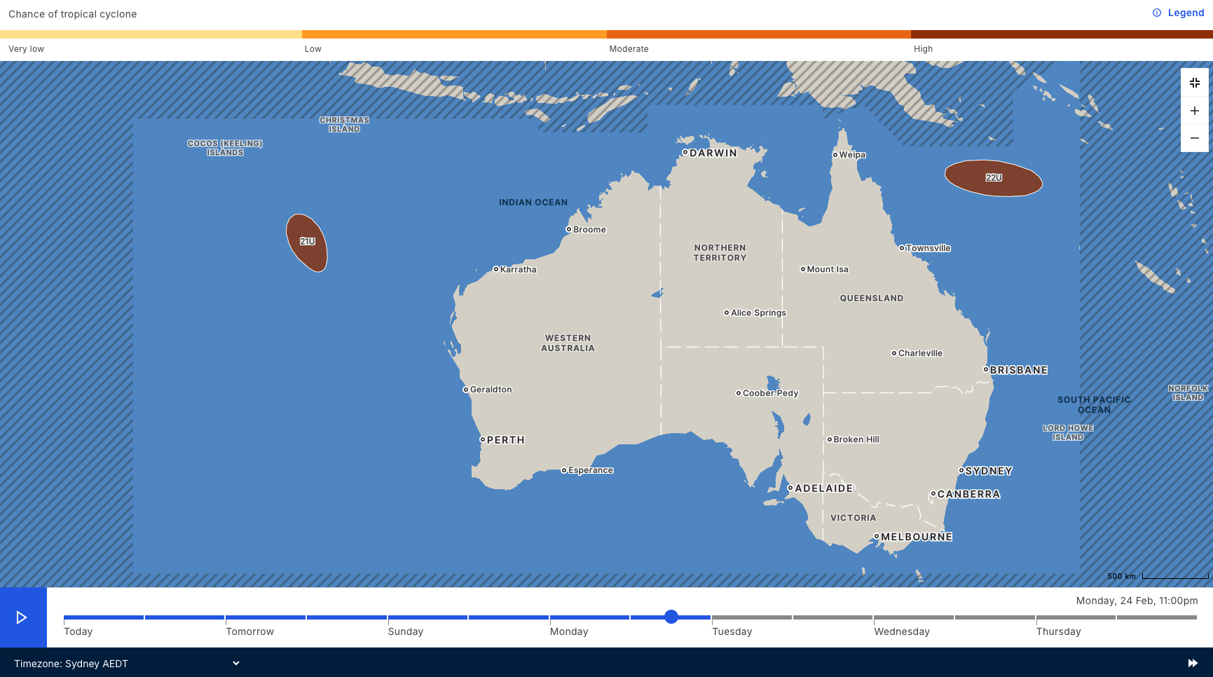
Image: Map showing a high chance of tropical cyclone development for two systems inside Australia’s area of responsibility early next week. Source: Bureau of Meteorology.
With potential for two tropical cyclones in Australian waters next week, any businesses across tropical areas of the country should keep a close eye the latest forecasts and advisories.
As the climate delivers increasingly severe weather events, their potential to impact your business operations grows.
DTN APAC, specialises in industry-leading forecast, alerting and threat analysis of tropical cyclones, offering you expert, customised solutions when the weather turns wild.
Providing rapid-update forecast information, we alert you to any low-pressure system gaining power within your region and, unlike other providers, can track its development out to 7 days. This gives you the time to prepare and safeguard your staff, sites and assets.
You will have the most precise weather intelligence charting rainfall, wind speeds and potential storm surges to help you make critical decisions quickly. Whether it’s adjusting key work schedules, protecting your staff or securing your site, we have the alerting capability to keep you steps ahead of the storm.
We will support you, 24/7, keeping you informed and making your critical decisions easier. For more information, contact us at sales.apac@dtn.com


