Two tropical cyclones have formed over the Indian Ocean to the northwest of Australia in the past 48 hours, with 75% of Australia’s cyclones so far this season becoming severe.
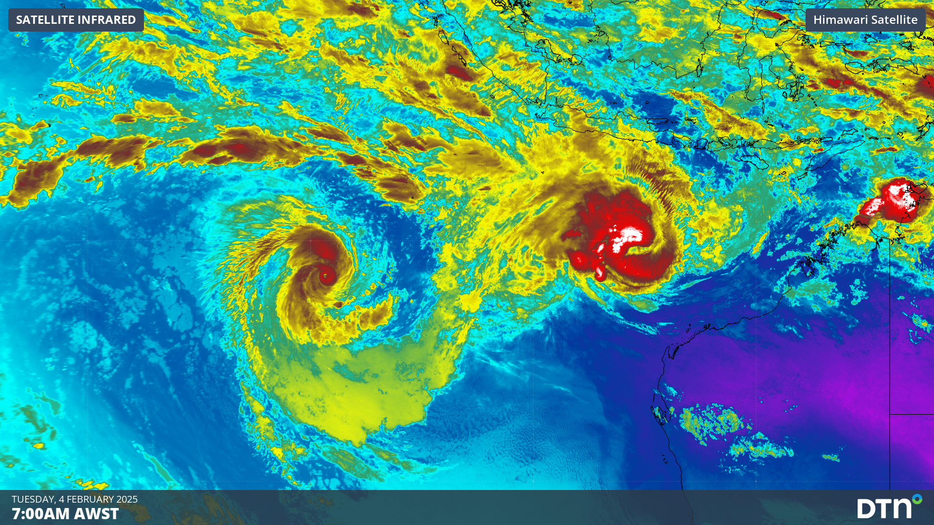
The satellite image below shows that an eye has developed in both cyclones, with cloud swirling around it in a clockwise direction as the sun rises over WA.
Images: Himawari-9 satellite images for four hours up to 6:30am AWST on Tuesday, February 4, showing Severe Tropical Cyclone Vince (left) and Taliah (right).
The two eyes are an indicator of the cyclone’s strength and structure, with both cyclones indeed severe category three systems.
Severe tropical cyclone Taliah
Tropical cyclone Taliah was the first to form to the north of the Pilbara on Sunday and deepened into a category three system early Tuesday morning.
At 7:10am AWST Taliah was located 740km northwest of Karratha, moving west away from the mainland at around 13km/h.
Taliah is unlikely to directly impact the mainland, however she is whipping up some decent waves around her centre. Fortunately, the continental shelf is protecting the Pilbara and Kimberley coastal waters somewhat, but waves could still reach up two to three metres on Tuesday.
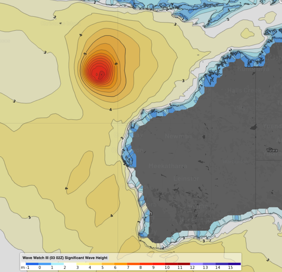
Image: Wave Watch III significant wave height forecast at 4pm AWST on Tuesday, February 4.
The waves and the cyclone could impact busy shipping routes to and from Australia’s mining hub in the Pilbara region.
Severe tropical cyclone Vince
Tropical Cyclone Vince formed on Monday well to the west of Australia’s mainland and rapidly deepened into a category three system overnight.
At 7:10am AWST, Vince was located around 740km southwest of the Cocos (Keeling) Islands, tracking west away from Australia, and is unlikely to impact the mainland or the Cocos (Keeling) Islands.
Why have so many severe tropical cyclones formed over the Indian Ocean this season?
All four of Australia’s tropical cyclones so far this season have formed in the Indian Ocean to the west of Australia, with three of the systems becoming severe.
The active cyclone season over the Indian Ocean has been caused by unusually warm sea surface temperatures off the northwest shelf of Australia. Waters are now sitting at 30 to 31°C, which is around 2 to 3°C above average for this time of year.
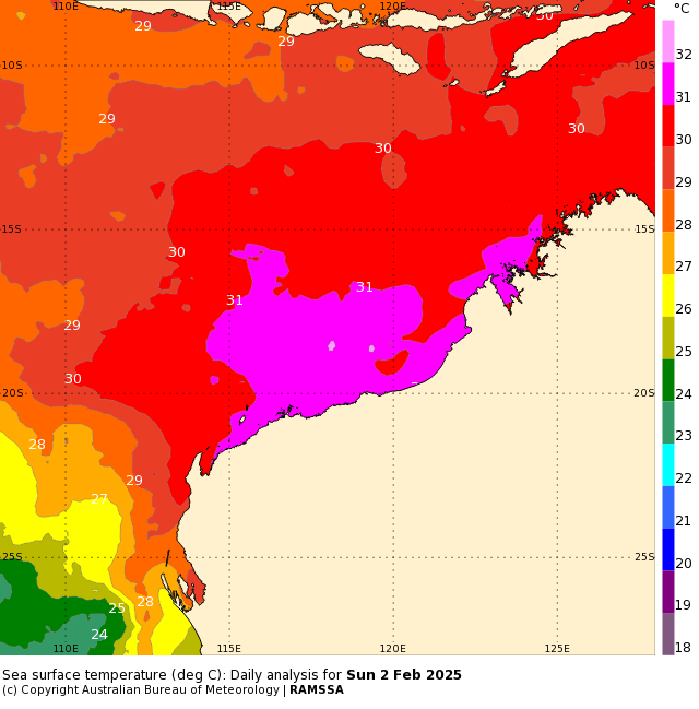
Image: Sea Surface Temperature (°C) on Sunday, February 2. Source: Bureau of Meteorology
Tropical cyclones require water temperatures of at least 26.5°C to form. With each degree of warmer water above this threshold, a tropical cyclone gains more thermal energy which it can convert into its powerful winds and structure. Warm waters increase the chance of the system becoming severe.
Another reason for the recent cyclone activity around northern Australia is the Madden Julian Oscillation (MJO) is in the Australian region, increasing the risk of cyclone development in the coming week or so.
The monsoon is also expected to arrive over Darwin in the coming 48 hours, which will also increase rainfall and thunderstorm activity across Australia’s north in the coming week. This is the latest arrival Darwin has seen on record, with the monsoon usually arriving in December.
Do you have industry-leading weather data and alerting to minimise risk for your offshore, port or logistics operations?
DTN APAC offers a comprehensive suite of services, refined through years of collaboration with the marine, ports and offshore industries, to optimise the safety and efficiency of your operations.
We work with you to understand your intrinsic operational challenges and customise high-precision forecasting, metocean and aviation services to your exact location and operational scope.
When working offshore, our solutions can underpin planning and safe execution for offshore oil and gas enterprises and wind farms. Our data can support your exploration, development, rig moving, shuttle tanker operations, and production and decommissioning phases. Whether your crews are on-site, being transported to shore, or diving to perform maintenance, we deliver tailored weather risk briefings to ensure you choose the optimal time to proceed.
DTN APAC’s trusted nowcasting and forecasting system, OpticastTM, allows you to rapidly respond to changing conditions offshore, en route and in port. We take your port topography and berth orientation into account, ensuring site-specific forecasts. For offshore oil & gas, wind farms, ports and logistics, we have your weather situational awareness covered, no matter where you are. We deliver real-time severe weather and lightning alerts to your team via your integrated dashboard: Portzone, and our Weatherguard app.
DTN APAC’s Total Lightning Network (TLN) ensures you avoid hours of unnecessary downtime by providing the most accurate technology in lightning detection and alerting. Safeguard your teams and assets with lighting and Dangerous Thunderstorm Alerts (DTAs), customised to your existing parameters and delivered in real-time across all devices in your network. You gain full spatial awareness of developing severe weather systems, allowing you to plan ahead and, where needed, execute your shutdown and evacuation procedures.
With extreme conditions slowing production and affecting infrastructure, safety and transport, trust us to deliver Australia’s most precise weather data and tailored insight, giving you decisive confidence when it’s most needed.
For more information contact us at sales.apac@dtn.com


