
Dangerous thunderstorms developed across northern WA in the early hours of this morning bringing intense rainfall to some mine sites in the region.
A broad low pressure trough sitting over northern WA was behind the wild storm activity over the weekend and into Monday.
The infrared satellite images below show the very tall, large and dangerous thunderstorms impacting the region on Monday morning.
Image: Infrared satellite images, with lightning and radar for the 6 hours leading up to 7am AWST.
These thunderstorms produced very heavy rainfall which led to the Bureau of Meteorology issuing a warning in the early hours of this morning.
Paraburdoo in the Pilbara region recorded a whopping 35.4mm in the 30 minutes to 4:49am.
The image below shows DTN’s flood forecast system for a mine site in the Pilbara region. It shows a red alert (highest alert threshold for client) for intense rainfall with around 130mm expected to fall in the client’s upper catchment on Monday.
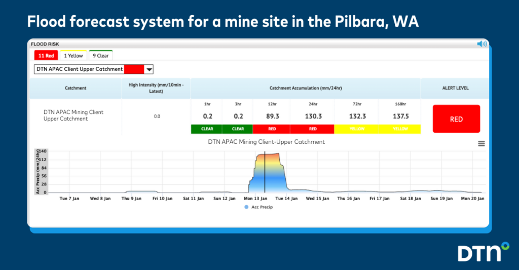
The system uses a combination of observations of Oracle gridded data (from midnight to 7am AWST on Monday morning- before the black line) for the mines catchment and Oracle rainfall forecast for the remainder of Monday (after the black line).
While severe thunderstorms have eased with much of the activity remaining near the coast at around 7am local Monday morning, thunderstorms with the potential for heavy rainfall are expected to redevelop later on Monday. You can see in the flood risk system above that the client’s catchment has a high risk throughout Monday.
DTN’s flood risk system equips our clients with detailed situational awareness, as well as the ability to monitor rainfall for any number of geofenced site sections or culverts.
The system helps prevent stalled production, damage to assets and infrastructure, and water management and supply chain delays with the following;
- Advanced geo-fenced technology: the system creates hundreds of virtual weather stations for each chosen catchment, enabling precise forecasts of rainfall intensity and accumulation on site.
- Real-time flood risk and alerts: we work with clients to define specific thresholds and alert the business of any potential breach forecast for any section of the mine
- Driven by precise high precision modelling: Opticast is DTN’s satellite-derived gridded nowcasting system, forecasting at 1.2km resolution and updating every 5 minutes.
The flood risk alerts produced by this system can be sent to anyone on site via SMS, email, via the client’s dashboard, or our Weatherguard app. For more information contact us at sales.apac@dtn.com
Thumbnail image Credit:Tyson Mowarin


