
It could be a tough week for insurers, with daily severe thunderstorms possibly bringing large hail, damaging winds, heavy rain, and flooding to parts of eastern Australia, including the capital cities.
This prolonged and dangerous thunderstorm outbreak will be generated by an extremely humid atmosphere and a series of low pressure troughs and lows throughout the week.
The extremely humid atmosphere is being caused by abnormally warm waters off eastern Australia, which are enhancing the moisture and energy available to showers and thunderstorms in the region.
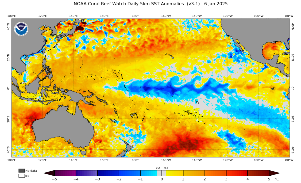 Image: Daily Sea Surface Temperature (SST) on Monday, January 6. Source: NOAA
The warm and humid environment will fuel severe thunderstorms each day for the next week across eastern Australia, with activity likely to peak later this week into next.
One key day of storms is Wednesday, when widespread severe thunderstorms are possible across northeastern NSW and southeastern Qld, with the possibility of large hail, heavy rainfall and damaging wind gusts. On Thursday, these severe storms will likely focus on Qld’s northwest and the central and southern interior.
Severe thunderstorms will then become scattered to widespread on Friday and Saturday across much of Qld and northeastern NSW, with a high risk of heavy rainfall which could lead to flooding in slow moving storms.
There are signs that severe thunderstorms will become widespread over northern and eastern Australia from Sunday, possibly impacting Sydney, Canberra, Melbourne, Brisbane and Darwin.
The image below shows high values of Convective Available Potential Energy (CAPE) or large amounts of energy in the atmosphere that could be used by thunderstorms, showing increased risk of severity.
 Image: CAPE forecast for 5pm on Sunday, January 12, according to ECMWF
CAPE values over 1,000 J/kg (white/yellow/red/pink) can produce severe thunderstorms, the higher the value the more ominous the threat.
The high CAPE values are forecast to continue over and east of the Great Dividing Range and across northern Australia on Monday, Tuesday and Wednesday next week. Sydney and Brisbane could see severe thunderstorms on several days next week, while Canberra and Melbourne’s highest threat is on Sunday.
Heavy rainfall will continue to be a risk on these days, however the higher CAPE values and dry upper air will pose the risk of large hail in some areas from Sunday into next week.
Given weather affects your business at all levels of operation, from risk assessment to sales and claim management, it’s worth gaining the foresight of our industry-leading, comprehensive weather services.
DTN APAC, a DTN company, offers you trusted weather intelligence, alerting and analytics to support your business, bringing ease to your risk and claims management.
Severe weather and conditions alerting
Weatherzone’s alerting allows your organisation to mitigate severe weather insurance claims and protect policy holders from lightning, hail, bushfires and other natural disasters. Address specific SMS alerts are sent up to 30 minutes prior to a severe storm’s impact, giving your customers time to prepare themselves, protecting both assets and life. Our alerting system combines the proven technology of TITAN Tracks, with our own Dangerous Thunderstorm Alerts (DTAs) and Total Lightning Network, so you are protected by the most precise service available.
Historical severe weather reporting
StormQuery creates storm reports based on historical data from the Bureau of Meteorology and lightning strike information from our own Total Lightning Network. You can draw historical lightning and severe weather reports – geo-tagged to any address and postcode – to quickly and accurately verify severe weather insurance claims. StormQuery is seamlessly embedded within the Weatherzone interface and is easy to visualise and utilise.
Long-range forecasts
Long-range forecasts enable you to prepare for the seasons ahead – whether it’s tropical cyclone risk, La Niña’s above average rainfall or the bushfire seasons of El Niño. With that foresight, you can equip your customers with the strategies they need to mitigate loss due to fire, flood and severe weather. Nurture your relationship with your customers by providing them with the tools to protect themselves and their assets from increasingly volatile conditions. Data from the forecast reports can also be incorporated into your reinsurance negotiations.
Rain, hail or shine: we are there for you, and your customers. For more information contact us at sales.apac@dtn.com.
Thumbnail image credit: @philipps.world.of.photography


