A stormy week is well and truly underway for WA, with more to come in the coming days.
Rain, and plenty of it, is set to soak virtually the entire state. And while some places will inevitably only see a few drops or miss out entirely, plenty of areas will see good falls.
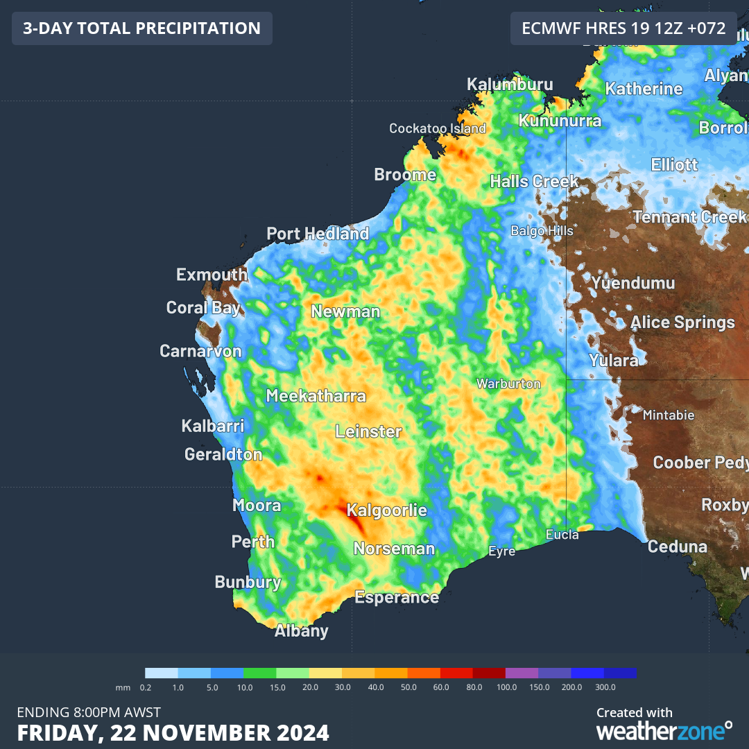
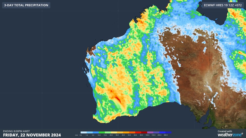
Image: Three-day accumulated rainfall totals in WA to 8pm Friday, November 22, according to the ECMWF model.
That includes arid areas in the centre and east of the state which are dry at the best of times, and southern areas where rainfall tends to dry up at this time of year.
This event has already well and truly kicked off, with solid falls recorded on Tuesday into Wednesday morning across the Kimberley, Gascoyne, Pilbara, Goldfields, Central West, Lower West, South West, Great Southern and Central Wheat Belt forecast districts.
Some of the rain has fallen briefly in heavy bursts during storms, while in some places it has accumulated steadily. Totals of note from 9 am Tuesday to 7:30 am Wednesday (AWST) include:
- 50mm or more at multiple locations in the South West forecast district, including Shannon and Bridgetown.
- 40mm at Golden Grove, a copper, lead, silver, zinc and gold mine in arid country about 250km east of Geraldton in the Gascoyne forecast district.
- 29.4mm at Kalgoorlie, the heaviest day of November rainfall in five years for WA’s largest inland city.
- 28.2mm at Morawa Airport in the Central West, and bear in mind that the site’s average rainfall for the whole of November is just 10.6mm.
- 18.4mm at Dalwallinu in the Central Wheatbelt, where the average for the whole of November is just 13.4mm.
- 17.2mm at Marble Bar, the heaviest daily fall since June this year.
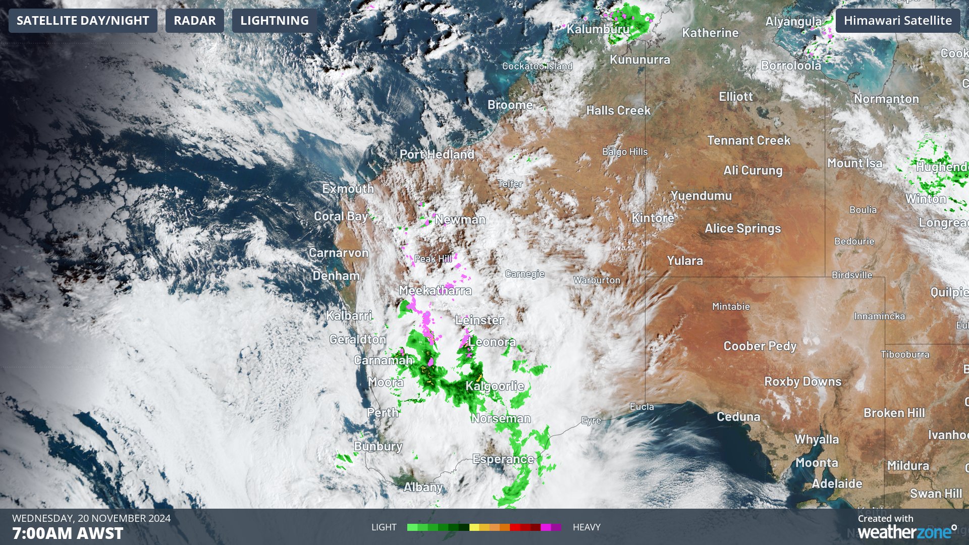
Image: The 7am combined radar and satellite image revealed cloud over a broad area of WA with rain and storms heaviest over inland parts of the state’s western half.
As the image above shows, there’s cloud but not much rain on the Perth radar this morning, although 3.8mm did accumulate in the city’s main gauge from Tuesday afternoon into Tuesday evening, with slightly higher totals in many suburbs.
While Perth daily totals will likely remain below 10mm this week before the weather clears in time for the first cricket Test between Australia and India starting on Friday, there’s plenty of potential for further solid falls elsewhere in WA.
What’s causing this rain?
The broad low pressure trough which is currently causing the rain and storms will be bolstered by an upper-level trough passing over the state during the next few days.
The arrival of that upper trough will destabilise the atmosphere and cause the surface trough (and associated rain and storms) to spread east – hence the coloured-in effect across the state on the map at the top of this story.
Stormtracker is a severe weather solution that can assist you in observing, in real-time, any storm or event that has the potential to impact your business.
Embedded in DTN’s industry interfaces, the system gives you a time advantage when monitoring conditions developing over your infrastructure and location.
Stormtracker is our Global Information System (GIS) tracking tool, providing multiple weather layers and zoom controls overlaid on a map of your location and infrastructure. You can choose a snapshot or full screen view, depending on your requirements. The maps allow you to monitor all weather, and specifically any systems likely to cause risk for your business. You also have the capacity to observe:
- real time lightning and thunderstorm alerts
- localised lightning strike frequency
- official warnings for storm, cyclone, wind, flood and fire
- sentinel hotspot fires and fire agency current incidents
Stormtracker’s radar imagery updates every 10 minutes, so you are always able to respond rapidly to changing conditions. You can customise alerting to notify you when your staff or infrastructure are under threat. With increased situational awareness, your ability to make informed decisions quickly is optimised.
DTN’s experience and intelligence gives you a clear path through complex situations. Let us assist you, offering actionable insight when extreme weather poses risk to your business. For more information please visit our website or email us at sales.apac@dtn.com.


