
Spring is in full swing in Australia, with a warm and humid environment set to bring thunderstorms to several states and territories in the next week.
A series of low pressure troughs and low pressure systems interacting with abundant atmospheric moisture will trigger daily showers and thunderstorms over Australia in the coming week.
This persistent wet and stormy weather is expected to bring rainfall to part of every state and territory during the next seven days, with widespread weekly falls of 10 to 30mm and some areas possibly in line for more than 100 mm.
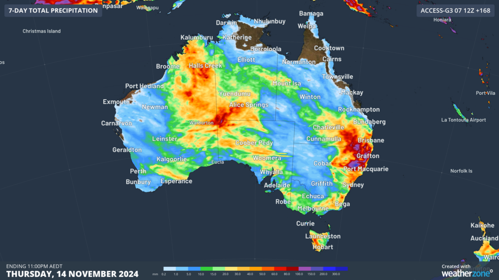
Image: Accumulated rain forecast for the next 7 days leading up to Thursday, November 14.
Despite the widespread rain and thunderstorm activity about to hit Australia, much of the NT’s Top End and Far North Queensland are likely to remain dry in the next week.
When and where will the storms occur?
Thunderstorms were already forming across parts of WA and Tas on Friday morning.

Image: Himawari-9 satellite image at 11:35am AEDT on Friday, November 8.
This activity is set to continue over the coming days, particularly across the northern and central interior of WA.
Thunderstorms and rainfall will also spread into parts of the NT and western and northern SA on the weekend into early next week, with some of these storms possibly becoming severe. Thunderstorm and rain activity will again increase during the middle of next week across parts of WA and the NT as another low-pressure system and trough impacts the region.
Further east, showers and thunderstorms should develop across southeast QLD and northeast NSW on Friday and may continue in parts of both states into the weekend. Rain and thunderstorm activity will increase across eastern Australia next week due to the passage of an upper-level trough, with and increasing possibility of severe storms.
With severe thunderstorms possible in multiple states and territories next week, be sure to check the latest forecasts and warnings for the most up-to-date information.
Stormtracker is a severe weather solution that can assist you in observing, in real-time, any storm or event that has the potential to impact your business.
Embedded in DTN APAC’ industry interfaces, the system gives you a time advantage when monitoring conditions developing over your infrastructure and location.
Stormtracker is our Global Information System (GIS) tracking tool, providing multiple weather layers and zoom controls overlaid on a map of your location and infrastructure. You can choose a snapshot or full screen view, depending on your requirements. The maps allow you to monitor all weather, and specifically any systems likely to cause risk for your business. You also have the capacity to observe:
- real time lightning and thunderstorm alerts
- localised lightning strike frequency
- official warnings for storm, cyclone, wind, flood and fire
- sentinel hotspot fires and fire agency current incidents
Stormtracker’s radar imagery updates every 10 minutes, so you are always able to respond rapidly to changing conditions. You can customise alerting to notify you when your staff or infrastructure are under threat. With increased situational awareness, your ability to make informed decisions quickly is optimised.
DTN APAC’ experience and intelligence gives you a clear path through complex situations. Let us assist you, offering actionable insight when extreme weather poses risk to your business. For more information please visit our website or email us at sales.apac@dtn.com.
Thumbnail image credit: QuentinDoig


