

The system that triggered over 600 thousand lightning strikes and damaging winds across WA yesterday is moving east across SA on Thursday morning.
A low pressure system and associated low pressure trough and cold front brought a dangerous storm day to WA yesterday.
Total Lightning Network detected 605,166 lightning strikes on Wednesday, October 2, as widespread thunderstorms lashed the interior of the state.
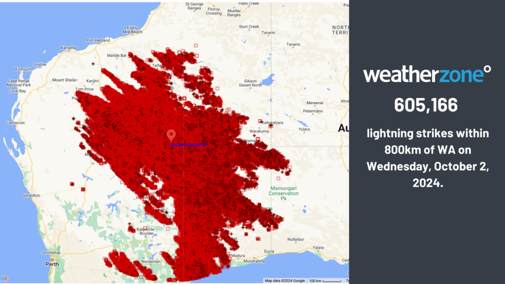
Severe thunderstorms also developed causing heavy rainfall and damaging winds across parts of the state.
Cape Leeuwin and Cape Naturaliste observed 94.5km/h and 98.2km/h wind gusts respectively early Thursday morning, October 3.
SA’s winds have already begun to pick up, with Ceduna recording an 83.3km/h gust at around 9am this morning.
An 800km line of thunderstorms is now entering SA on Thursday morning, as the strong cold front impacts the state.
Image: Himawari-9 satellite image at 7:30am ACST on Thursday, October 3.
Showers have already begun impacting the western parts of the state and will reach the eastern parts later today. Gusty thunderstorms may become severe across the west of the state on Thursday, with strong winds extending into the upper atmosphere.
Damaging winds in the absence of thunderstorms are forecast across much of the West Coast and parts of the North West Pastoral districts this morning and early afternoon. The strong winds in the remainder of the state are also likely to elevate wind power in the next 24 hours.
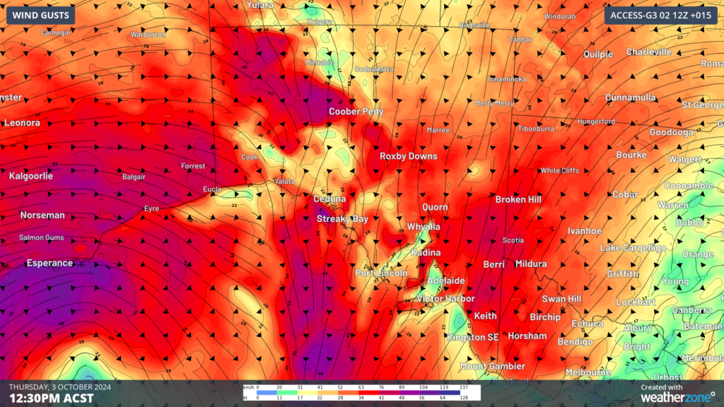
Image: Instantaneous wind gust forecast at 12:30PM ACST on Thursday, October 3, according to ACCESS-G.
In the image above you can see northerly winds impacting the state on Thursday afternoon; these winds are dragging a warm airmass into the state. Adelaide’s temperature is forecast to reach 28°C ahead of the front today, however the city’s maximum will drop to around 19 to 21°C for the long weekend.
The cold front will continue to march across the southeastern states on Friday and Saturday, bringing showers and thunderstorms. Looking ahead, another low will sweep across the south on the weekend potentially generating damaging winds for parts of Tas, southeast SA, Vic and southeast NSW.
Stormtracker is a severe weather solution that can assist you in observing, in real-time, any storm or event that has the potential to impact your business.
Embedded in DTN APAC’ industry interfaces, the system gives you a time advantage when monitoring conditions developing over your infrastructure and location.
Stormtracker is our Global Information System (GIS) tracking tool, providing multiple weather layers and zoom controls overlaid on a map of your location and infrastructure. You can choose a snapshot or full screen view, depending on your requirements. The maps allow you to monitor all weather, and specifically any systems likely to cause risk for your business. You also have the capacity to observe:
- real time lightning and thunderstorm alerts
- localised lightning strike frequency
- official warnings for storm, cyclone, wind, flood and fire
- sentinel hotspot fires and fire agency current incidents
Stormtracker’s radar imagery updates every 10 minutes, so you are always able to respond rapidly to changing conditions. You can customise alerting to notify you when your staff or infrastructure are under threat. With increased situational awareness, your ability to make informed decisions quickly is optimised.
DTN APAC’ experience and intelligence gives you a clear path through complex situations. Let us assist you, offering actionable insight when extreme weather poses risk to your business. Please visit our website or email us at apac.sales@dtn.com.




