Huge differences in temperature will be experienced across the southeastern corner of the country this Thursday as a classic spring weather pattern kicks in.
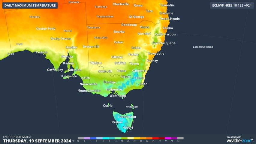
- Hobart should reach a top of 13°C but it will feel much colder with showers and gusty winds, while snow could fall as low as 300 metres above sea level on kunanyi/Mt Wellington, and as low as 200 metres in the state’s southwest.
- Melbourne will shiver its way to a top of just 16°C but it will likely feel much colder with showers and gusty westerly winds, while small hail is possible this evening as even colder air surges through.
- Sydney, by contrast, will reach a balmy 28°C, with barely a cloud in the sky.
- Brisbane will also experience sunny skies as it heads for 28°C today, which is well above its average September maximum of 25.7°C.
- Adelaide is also in for a chilly one, with a top of 16°C expected under clearing skies in the same week as it registered its coldest spring morning on record.
While you obviously expect cities like Sydney and Brisbane to be much warmer than Melbourne and Hobart at this time of year, today’s contrast in both temperature and weather conditions is more stark than usual. For that, you can thank an active cold front down south.
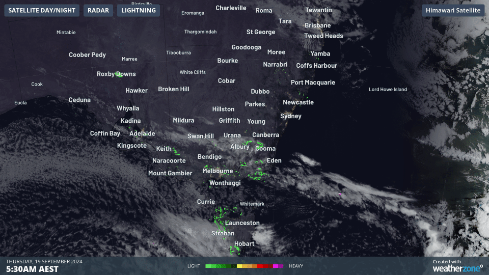
As you can clearly see on the two-hour radar loop to 7:30am Thursday, showers and a field of speckled cloud (which indicates cold air) are whipping through Tasmania, South Australia and southern NSW.
Indeed snow has been falling early on Thursday morning at mainland ski resorts – all of which are closed except for Perisher.
As the day progresses, anywhere north and/or east of Canberra should remain largely immune to the showery weather. And while cool air will make it as far north as the NSW Central Tablelands by Friday, coastal NSW will remain dry and relatively warm all week.
Speaking of Canberra, the national capital had an interesting night from a meteorological perspective.
- Just three nights ago, Canberra dipped to –6.9°C, its lowest spring temperature on record.
- Last night, under mild northwesterly winds, Canberra was 10.2°C at 2am, while the mercury fell only as far as 5.5°C just after 4am.
Thursday’s temperature contrasts across the southeast are well illustrated in the map below, which shows how Thursday’s maximums will reach the high twenties in coastal and northern NSW, while much of Tasmania and southern Victoria will struggle to reach the mid-teens.

Weatherzone Business has grown to become the outright leader within the Australian energy market, serving wind, solar, hydro, trading, utilities and network companies.
You can’t control the weather, but you can gain precision insights to optimise your response. What lights us up is providing your energy business with tailored weather information to reduce your risk and keep you moving ahead of the curve.
Our services cover all aspects – from wind and solar generation to demand forecasts, wholesale markets to retail so, no matter where your company sits, we have solutions for you. We have worked closely with market participants to create products that meet the evolving needs of the sector, aiming to increase safety and profitability for our customers.
Benefit from the timely delivery of accurate weather information, allowing informed and effective decision-making. For more information, please visit our website or email us at apac.sales@dtn.com.


