If you’re sick of the winter chill, how does a temperature approaching 20°C in Melbourne sound for the first two days of next week? How about 22°C in Adelaide, 18°C for Canberra, and even the strong possibility of 20°C in Hobart on Tuesday?
An early taste of spring is coming to a broad area of southeastern Australia in the second full week of August, as daytime temps soar up to seven degrees above average.
Weatherzone’s synoptic chart for Tuesday, August 13, shows you what’s going to cause the outbreak of winter warmth.
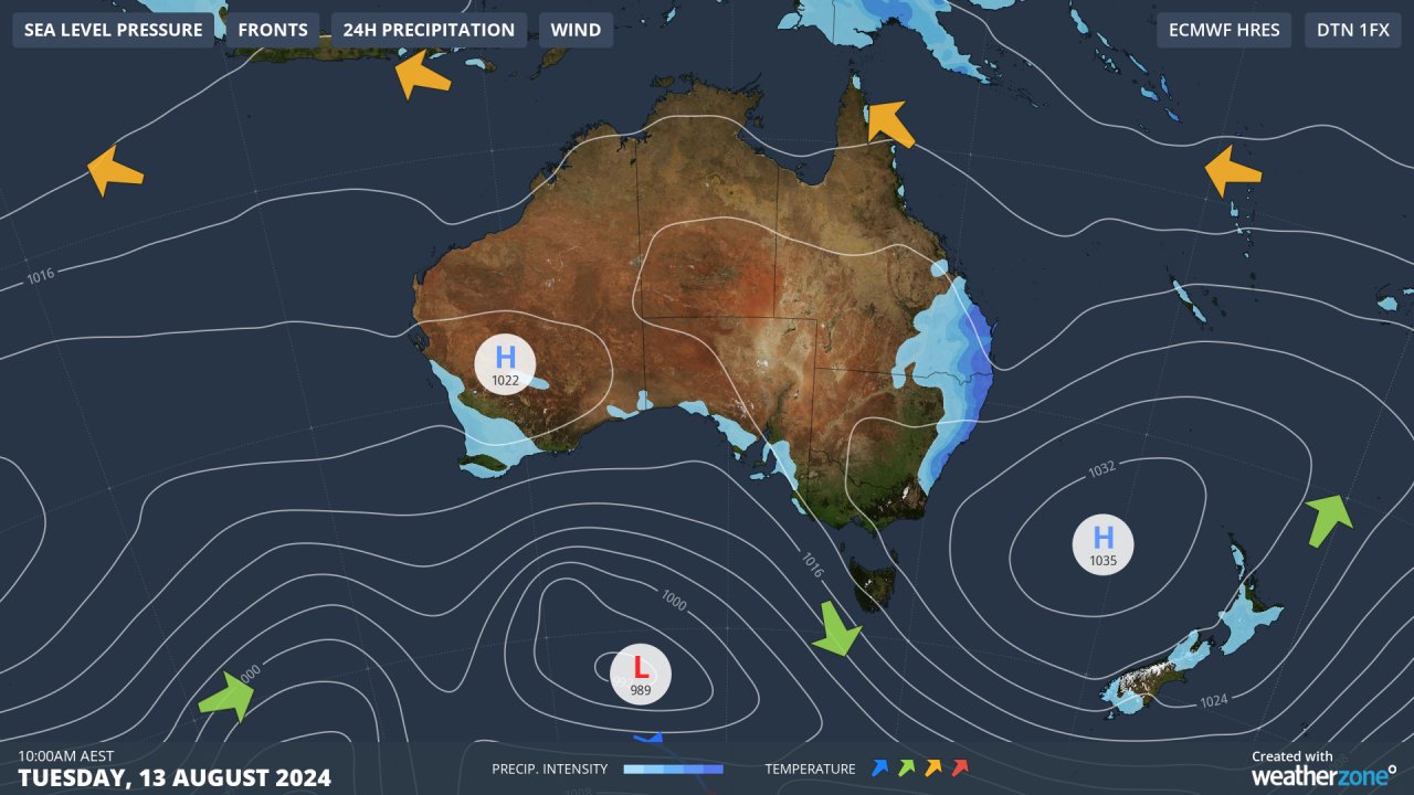
For all of this week, a strong band of high pressure has parked itself over mainland Australia, deflecting any Southern Ocean cold fronts well south of the mainland.
Most of the country has seen clear skies with daytime temps close to, or only slightly above, the August average.
As the high pressure system currently centred over eastern Australia moves into the Tasman Sea on Monday (see chart above), air circulating anti-clockwise around it will drag air from Australia’s interior southwards in a mild northerly airstream.
To give you an indication of the unseasonable warmth we can expect, here are forecast temps for Tuesday compared to the August averages for the cities mentioned at the top of this story.
- Melbourne: Tuesday forecast max 19°C, August average 15.0°C
- Adelaide: Tuesday forecast max 22°C, August average 16.1°C
- Canberra: Tuesday forecast max 18°C, August average 14.2°C
- Hobart: Tuesday forecast max 20°C, August average 13.2°C
Often with warm August northerlies and northwesterlies, a strong cold front lurking in the Southern Ocean coms to bite afterwards, bringing a strong cold change.
At this stage, long-range models suggest that such a change is looming towards the end of next week, but it won’t arrive immediately after the warmest day – which as mentioned looks likely to be Tuesday in most spots.
So enjoy the winter warmth, and rest assured the temperature switch won’t instantly flick to freezing on Wednesday. But the 2024 winter is not done yet, that much appears almost certain.
And if you’re wondering why we didn’t mention Sydney – the other state capital in the southeast – that’s because its temps next week will likely be moderated by cloud and rain in an onshore easterly wind flow, which again you can see illustrated in the chart above.
The other cities mentioned should be mostly dry from the weekend onwards as the warm air approaches, apart from the chance of a brief passing shower or two midweek.
Weatherzone Business, a DTN company, supplies precise weather intelligence to over 75% of the National Energy Market (NEM) participants and is the trusted provider for Australia’s Market Operator.
We offer weather data and analytics to support all aspects of your renewables business, with a wide range of specialised services covering energy generation and weather forecasting, to site-specific severe weather alerting and historical reporting. To find out more, please visit our contact page or email us at apac.sales@dtn.com.


