
While much of WA is basking in autumnal warmth today, a cold airmass, heavy rain, small hail and blusterous winds are on their way.
The video below shows a cold front and an associated thick cloudband quickly approaching WA on Wednesday.
Video: Himawari-9 satellite images at 11:40am AWST on Wednesday, July 17
You may also see in the bottom left of the image above a broad area of speckled cloud. This is a tell-tale sign that a large mass of cold polar air has broken away from the Antarctic region and is venturing into the relatively warm mid-latitudes.
The coldest air should arrive in southwest WA later Thursday into Friday, causing temperatures to plummet across the region.
The image below shows the cold airmass over southwest WA on Friday morning, a huge contrast to the warmth in the north.
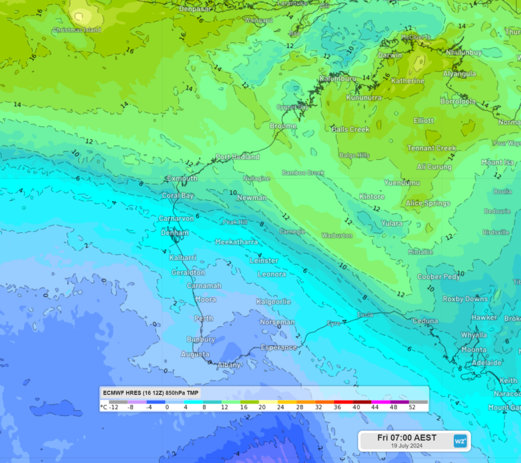
Image: 850hPa temperature at 5am WST on Friday, July 19 according to ECMWF
While Perth is enjoying another warm 22°C today, as they did on Tuesday, temperatures on Thursday and Friday are forecast to stay below 18 °C. Inland areas of the southwest should see the coldest temperatures in the next few days, with maximums only reaching around 14 °C.
The cold temperatures will be accompanied by several days of strong wind, which is likely to make the temperature feel much colder than the actual. These winds will elevate wind power for several days in the region.
As this frigid airmass moves onshore with a band of rain, the southwest could see small hail on Thursday.
In addition to the cold air and small hail, heavy rainfall should begin to impact the southwest overnight Wednesday into Thursday, including the Perth region.
Severe thunderstorms are also possible as the front moves onshore tonight into tomorrow, with the possibility of heavy rainfall. Keep an eye out for the latest warnings here.
The image below shows the rain forecast in the next few days, with widespread falls of 10 to 20mm forecast and isolated falls of 30 to 60mm possible along the southwest WA coast.
![]()
Image: Accumulated rain forecast for the 19 hours to 5am WST Friday, July 19, according to ECMWF
Looking ahead the rain should mostly clear from Friday, apart from the odd shower or two and temperatures will warm slightly on the weekend.
Weatherzone Business has grown to become the outright leader within the Australian energy market, serving wind, solar, hydro, trading, utilities and network companies.
You can’t control the weather, but you can gain precision insights to optimise your response. What lights us up is providing your energy business with tailored weather information to reduce your risk and keep you moving ahead of the curve.
Our services cover all aspects – from wind and solar generation to demand forecasts, wholesale markets to retail so, no matter where your company sits, we have solutions for you. We have worked closely with market participants to create products that meet the evolving needs of the sector, aiming to increase safety and profitability for our customers.
Benefit from the timely delivery of accurate weather information, allowing informed and effective decision-making. To find out more, please visit our contact page or email us at apac.sales@dtn.com.


