
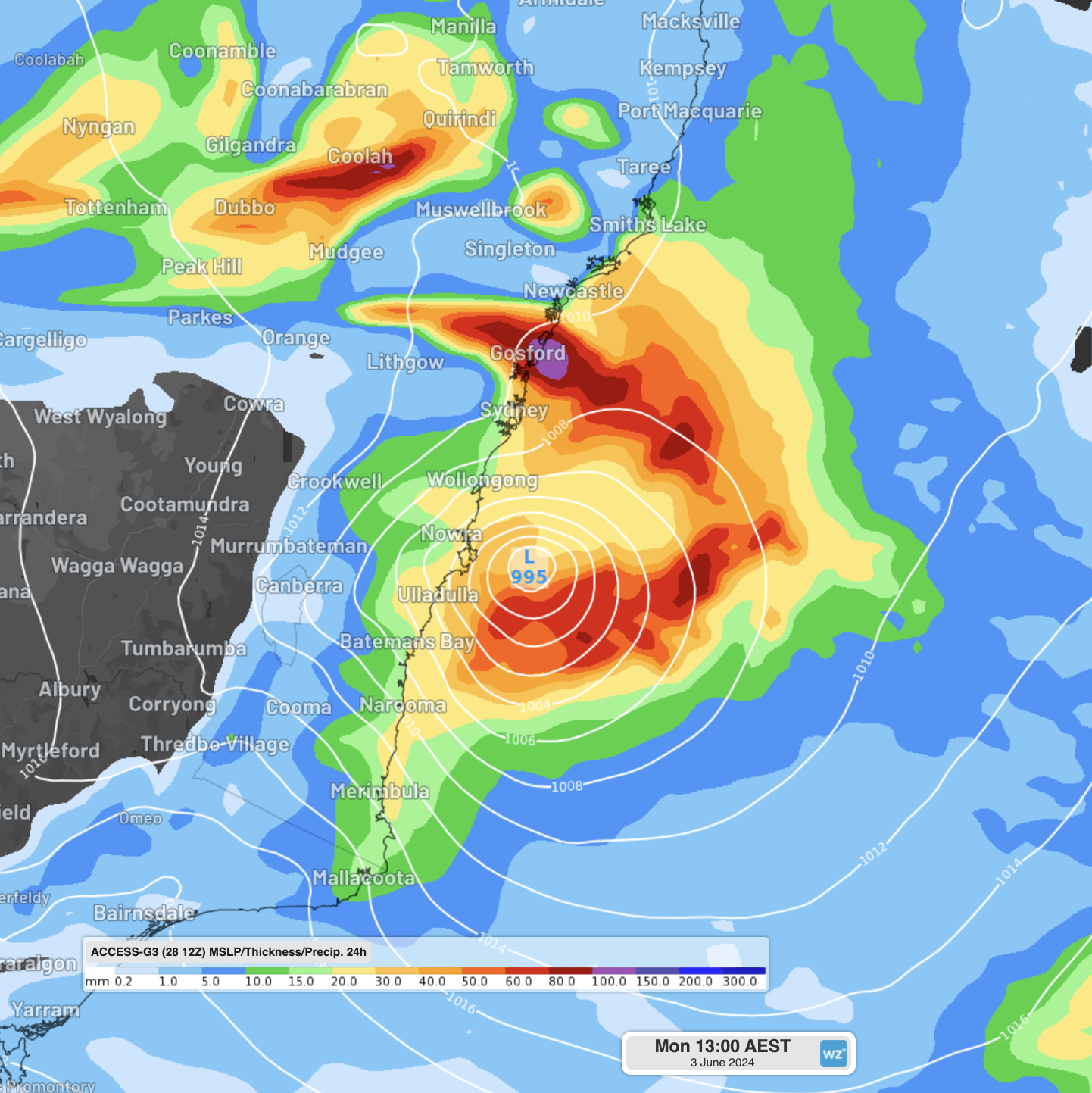
An East Coast Low is expected to form off the NSW coast this weekend, with heavy rainfall, powerful winds, erosive surf and cold temperatures forecast.
An East Coast Low (ECL) is a type of low pressure system that forms close to the east coast of Australia and stays close to shore for at least 24 hours. By definition, ECLs produce any combination of damaging-to-destructive winds, heavy rainfall, flooding, or powerful, erosive surf, with the most severe ECLs producing all four together.
ECLs have the power to destroy beaches (like Collaroy Beach in June 2016), cause major flooding (like Sydney and the Hunter in April 2015), and even beach bulk carriers (like the Pasha Bulker in June 2007 and the Sygna in May 1974). The last ECL to impact Australia was back in July 2022, with severe ECLs forming every 2-4 years on average.
Where will this East Coast Low impact?
This ECL is currently expected to form on Sunday afternoon, and rapidly intensify during Sunday night and into Monday morning. Some computer models even show the intensification continuing into Tuesday.
While models are struggling to agree on specifics (like where the heaviest rain will be), most suggest that the South Coast of NSW and the North East of Tasmania will be the most affected. However, heavy rainfall, damaging winds and powerful surf are possible all the way from Newcastle and Sydney in NSW to East Gippsland in Victoria, and down the Tas coast to Hobart. Historically, heavy rainfall has also pushed in as far inland as Canberra and the Snowy Mountains (where it may fall as snow like in July 2020 – when a system brought snow from the less common easterly direction).
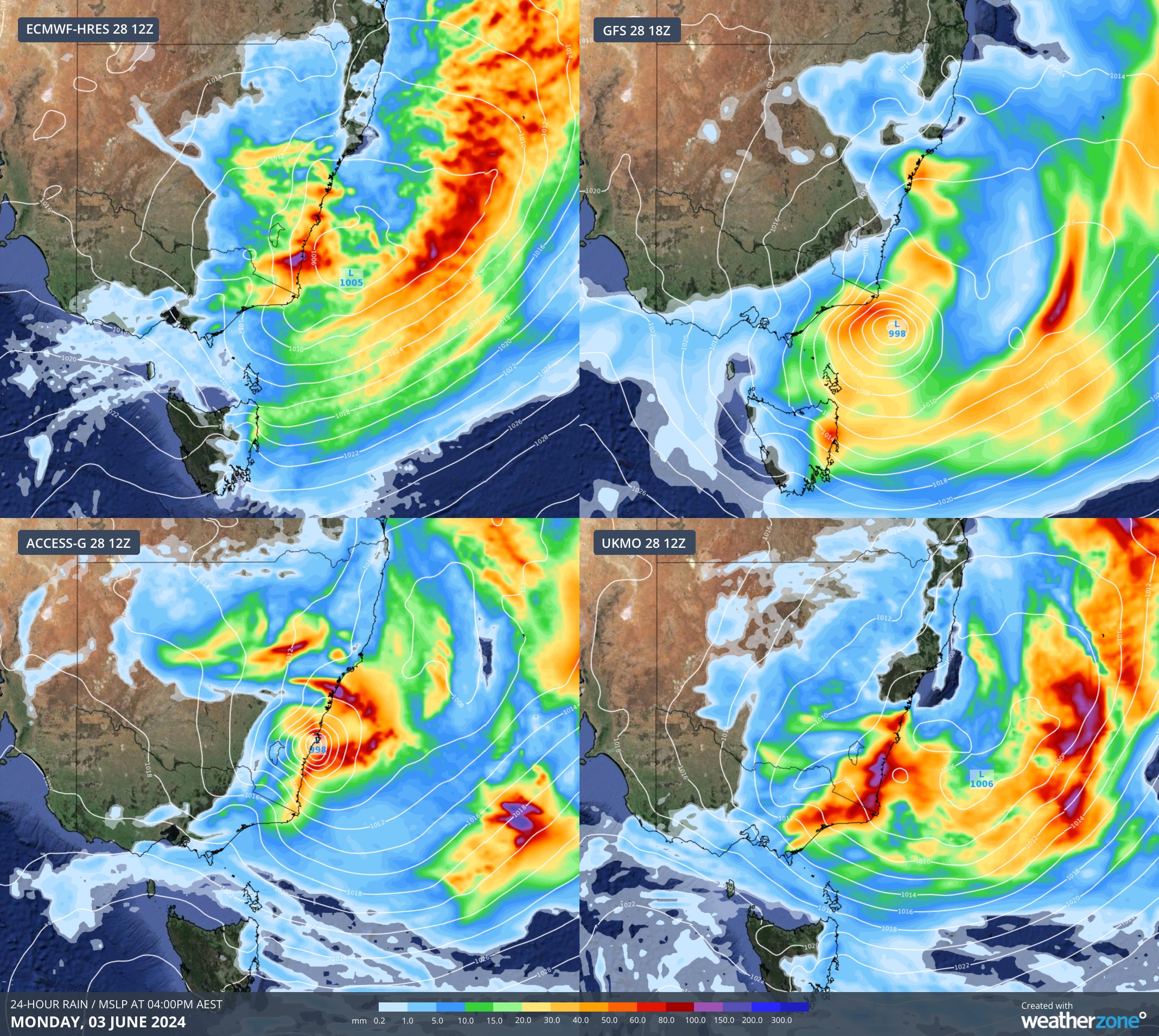
How intense will the worst conditions be?
Most models suggest the heaviest rainfall will be around 100-200mm, with isolated pockets of 250+mm. Winds along the coast will likely reach sustained 50-70km/h, gusting 100-120km/h in the worst affected areas. Significant wave heights are likely to reach at least 4.5 metres, but have the potential to go as high as 7 metres. Maximum wave heights could reach upwards of 10-12 metres over the open ocean.
Why is this system expected to be an East Coast Low?
ECLs differ from other types of severe weather systems, like the coastal trough or black nor’easter from earlier this year, as they undergo rapid intensification, allowing them to become much more intense. Some of the main set-up characterises of this ECL are:
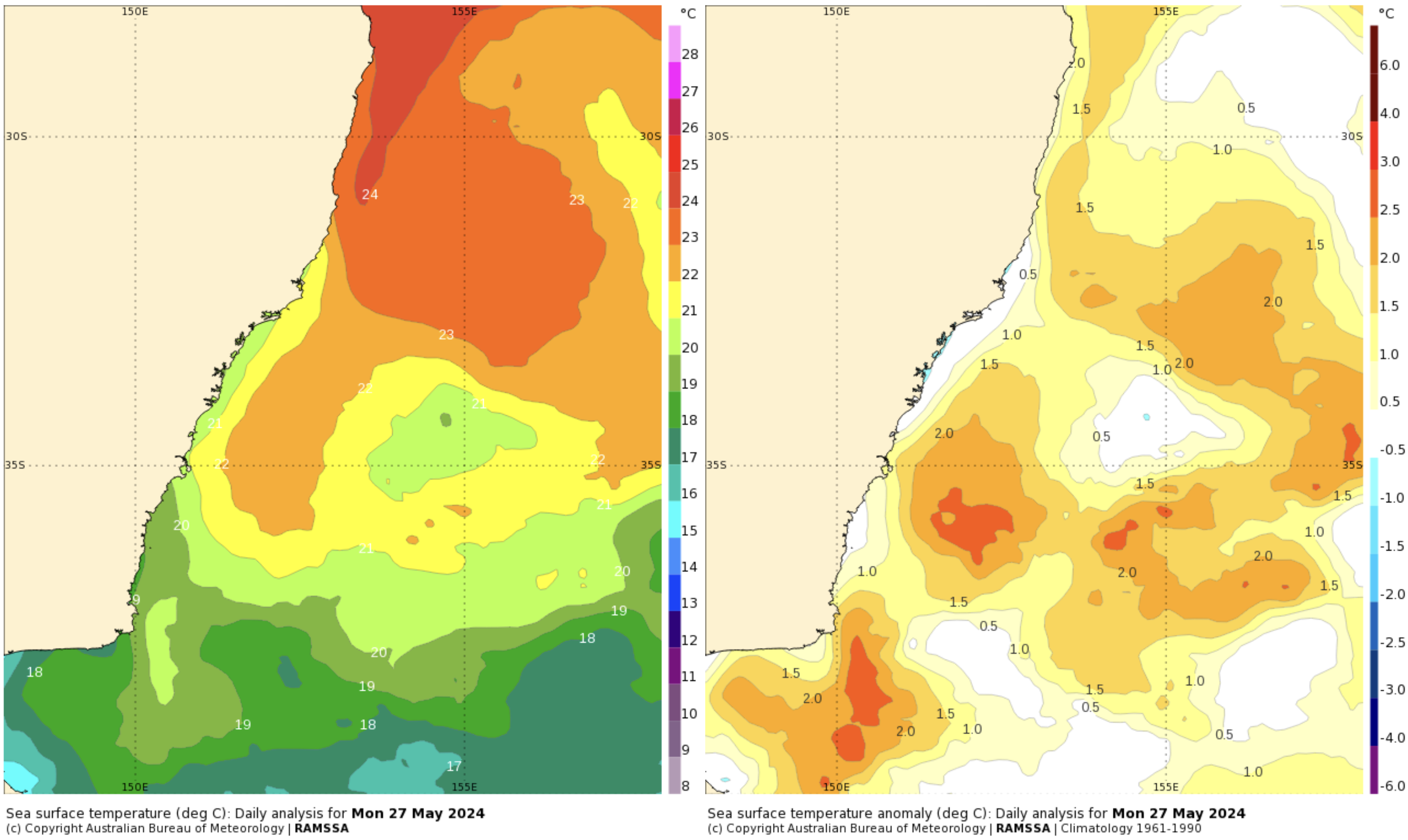
- Warm ocean temperatures: Warm oceans fuel ECLs, providing them moisture and rising air. At present, there is a tongue of warm 22°C water (left image) extending down the East Australian Current (EAC), representing waters up to 2.5°C warmer than average for this time of year (right image).
- Baroclinic Instability: When cold air sits right next to warm air, it powers winds and increases convection. In the image below, cold air is sitting over inland NSW, while warm air is extending down over the ocean just off the coast. Where these two airmasses meet (almost perfectly along the coast) air will start to rise, and winds start to rotate. This rotation ‘spins-up’ the low pressure system faster.
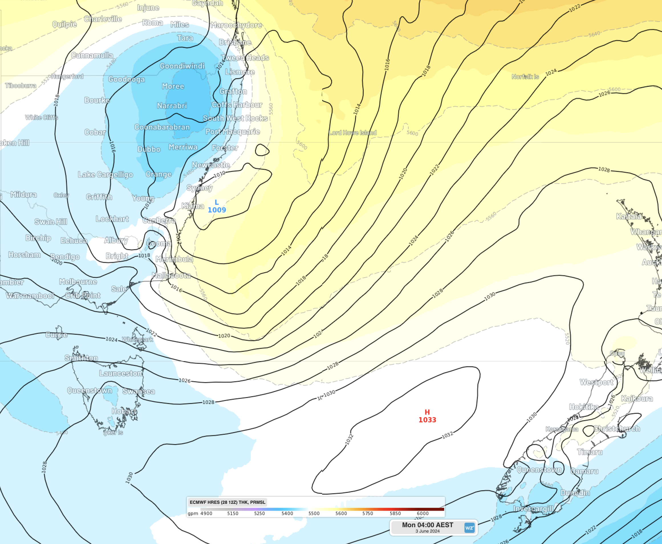
- A blocking high pressure system: One of the most important conditions for an ECL is a broad high pressure system in the Tasman Sea to keep the low pressure system close to the coast. In the image above, the broad high pressure system can be seen just to the west of New Zealand, trapping the low close to the NSW coast.
- An upper trough sitting over the Great Dividing Range. This condition is necessary to set up a circulation where air rises over the low, is transported at about 5.5km elevation towards the high, where it settles. This lowers the pressure of the low (making it deeper) and also increases the pressure of the high (known as anti-cyclonic intensification). Since winds are driven by the difference between high and low pressure, this causes the winds to increase rapidly. Here, a deep upper-level trough will be sitting over the Great Divide from Sunday afternoon, allowing the low to rapidly deepen on Sunday night and Monday morning.
With such severe weather expected over the weekend and early next week, it’s important to keep up to date with the latest warnings issued by the Bureau of Meteorology. We will also keep you up to date on the Weatherzone News Feed with more details about the weather expected from this system over the coming days.
DTN APAC supports all our clients with detailed forecasts and video briefings from our weather risk experts during these severe events. To find out more, please contact us.




