Prosper in a dynamic world
Search

Northwest cloudband to bring welcome rain

There’s a feature on this week’s weather charts which we haven’t seen for many months in Australia and which is a sign that winter is almost upon us: a northwest cloudband.

  • Northwest cloudbands are vast layers of cloud that flow over Australia from the northwest. Once fully developed, the cloudband stretches across the country like a sash from the northwest to the southeast.
  • Northwest cloudbands form when humid and warm tropical air over the Indian Ocean moves towards the southeast. As this warm and humid air moves further south, it rises over cooler air in the mid-latitudes and produces clouds.

READ MORE: WHAT IS A NORTHWEST CLOUDBAND?

Usually, northwest cloudbands produce rain – sometimes light, sometimes quite heavy – but usually rain of the steady, soaking variety rather than the bursts of showers which typically lash southern Australia from southwesterly cold fronts.

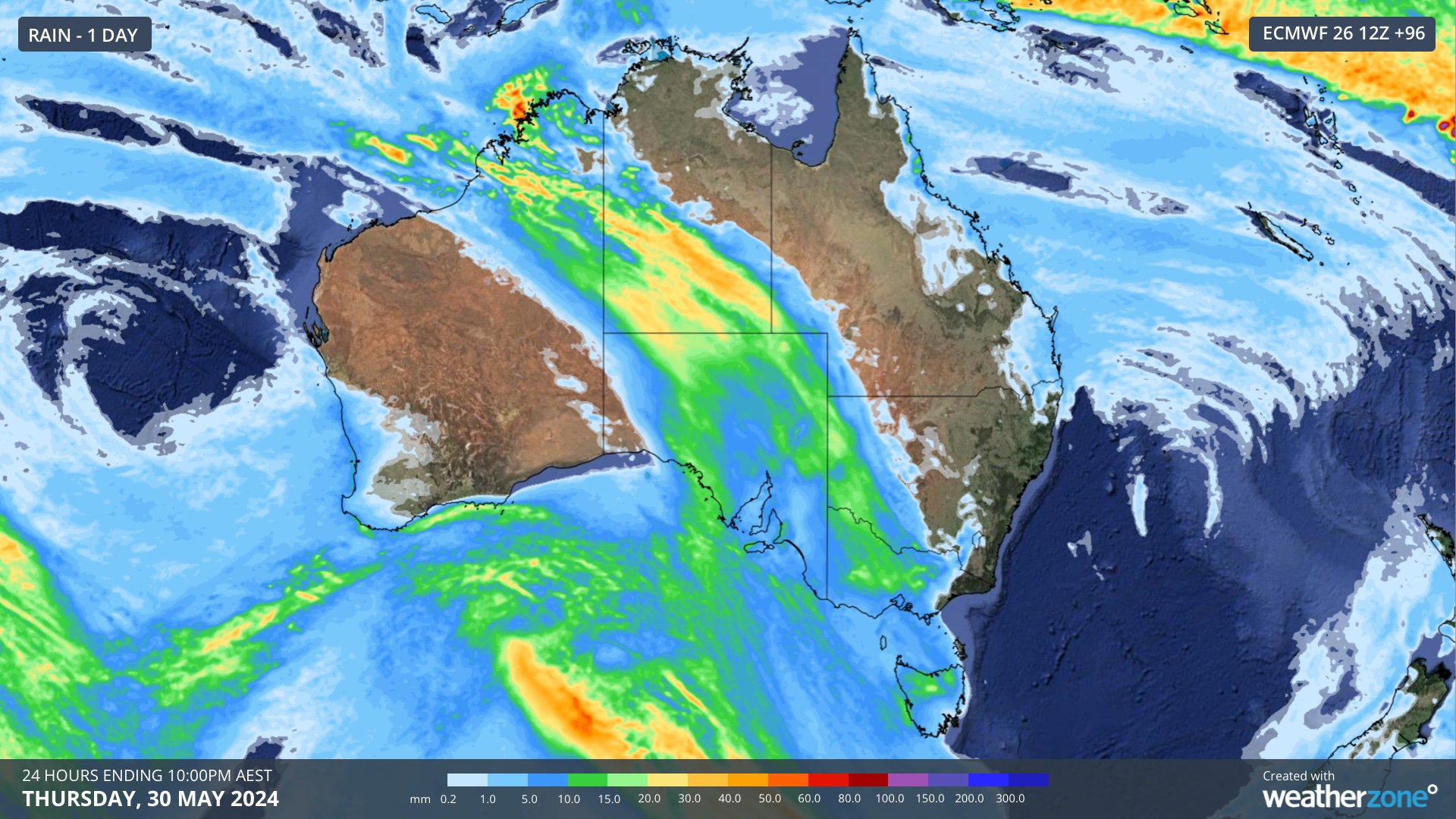
The chart above shows one prognosis for rain produced by this week’s northwest cloudband in the 24 hours to 10 pm this coming Thursday.

For parched parts of Western Australia, South Australia, Victoria and inland NSW, this is a welcome forecast.

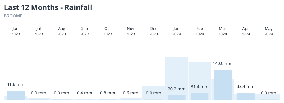
Coastal parts of northwest WA had very little rain during the wet season this year. Broome has recorded 228mm so far in 2024, 310mm short of average. Port Hedland has had a measly 35mm, compared to its January to May average of 246mm.


For now, it appears that at least some rain is coming to areas of SA, Vic, NSW and Tas that desperately need it and we’ll keep you updated on this system throughout the week.

Miningzone, by DTN APAC, is the only weather tracking and alerting solution purpose-built for the resources sector. To find out more, please visit our website or email us at apac.sales@dtn.com.

Latest news

Satisfy your weather obsession with these news headlines from around the nation, and the world.

Tropical cyclone season begins with warm oceans surrounding northern Australia

The 2025-26 tropical cyclone season has begun with abnormally warm oceans surrounding northern Australia, signalling an increased risk for severe tropical cyclones in the coming months. The Australian tropical cyclone season runs from November 1 to April 30. During this six-month period, there are usually about 9 to 10 tropical cyclones in the Australian region, […]

7.8 million lightning pulses detected by DTN’s Total Lightning Network over Australia in one week

A barrage of thunderstorms battered large areas of eastern and northern Australia over the past week, producing close to 8 million lightning pulses across the country and more than 4 million over Queensland alone. DTN’s Total Lightning Network (TLN) detected around 7.79 million lightning pulses above Australia last week. This lightning was observed over every […]

Warmest October on record for Sydney, Brisbane

Sydney and Brisbane just had their warmest October on record, despite a relatively cool end to the month. A surge of cold air caused temperatures to plummet in eastern Australia earlier this week. In Brisbane, the temperature only reached 22.2°C on Tuesday, while Sydney’s maximums remained below 18°C on both Tuesday and Wednesday. These chilly […]

Australia’s 2025-26 tropical cyclone outlook

The Australian region is primed for severe tropical cyclones this season, despite an ongoing trend of reduced tropical cyclone activity over Australian waters in recent decades. Australia’s tropical cyclone season officially runs from the start of November to the end of April. During this six-month period, the Australian region usually sees around 9 to 10 […]