
The BoM has officially placed Australia on a La Niña watch, less than a month after El Niño was officially declared over.
“There are some early signs that a La Niña might form in the Pacific Ocean later in 2024,” the BoM reported in its May 14 update.
“As a result, the Bureau’s ENSO [El Niño–Southern Oscillation] Outlook has shifted to La Niña Watch.”
What is La Niña?
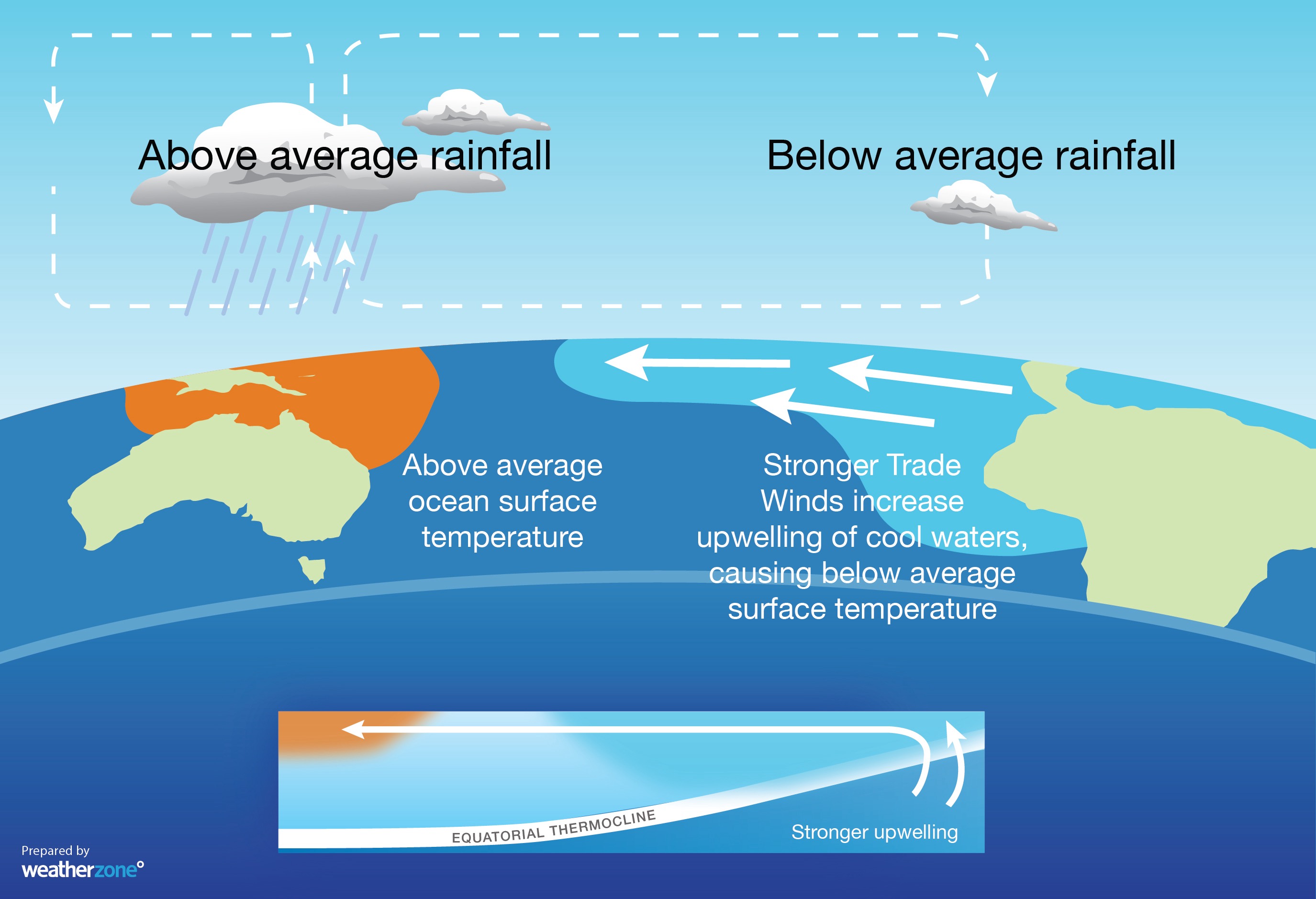
- La Niña is a broad-scale circulation in the Pacific Ocean that is characterised by warmer-than-average sea surface temperatures to the northeast of Australia and abnormally cool water in the central and eastern equatorial Pacific Ocean.
- The warm oceans and humid atmosphere that are associated with La Niña typically cause increased convection over the western side of the tropical Pacific Ocean. This in turn drives above average rainfall and cloud cover across much of Australia.
In its statement on Tuesday, the BoM said that when La Niña Watch criteria have been met in the past, a La Niña event has subsequently developed around half the time.
The BoM said ENSO will likely remain neutral until at least July this year, however the early indications that a La Niña could eventuate in the second half of 2024 include:
- Sea surface temperatures (SSTs) in the central Pacific have been steadily cooling since December 2023.
- This surface cooling is supported by a significant amount of sub-surface cooling in the central and eastern Pacific.
Australia’s last La Niña ended in 2023. It came at the end of a triple La Niña in 2020/21, 2021/22 and 2022/23, just the third time in recorded history that the event has occurred three years in a row in Australia.
The shifting climate is bringing increased complexity and greater risks to businesses worldwide. We are here for you, delivering trusted weather solutions to optimize your operations and profitability.
DTN APAC is a diverse team, with global forecasting, product development and analytics expertise. Couple this with extensive industry experience spanning Aviation to Energy, and we are primed to assist you in strengthening your response to weather
impact.
We work hard to identify your operational pressures and tailor our services and products to meet your needs. Concise communication, giving you full situational awareness exactly when you need it, is our focus. We want to reduce weather risk in your operations, every day.
We deliver clear and comprehensive weather data, personalised risk assessments and briefings to you and your team, so that your critical decisions can be made with confidence.
We are available 365 days a year, so you always have the timely guidance you require, especially when severe conditions hit.
You have our insights to rely on to see you through complex situations, minimising potential loss of profit and maximising the safety of your staff and assets. Contact us here.




