
The end is in sight to the relentless soaking and cloud on parts of the New South Wales coast, with a period of much drier weather ahead.
During the first 12 days of May, Sydney recorded an average of two and a half hours of sunshine, which is well below the average of six hours that the city sees in May. This has broken the May record which was set in 1979, when the first 12 days of May averaged three hours and 15 minutes of sun each day. The map below shows that rooftop solar contribution to generation in NSW dropped significantly in May, in response to this cloudy period.
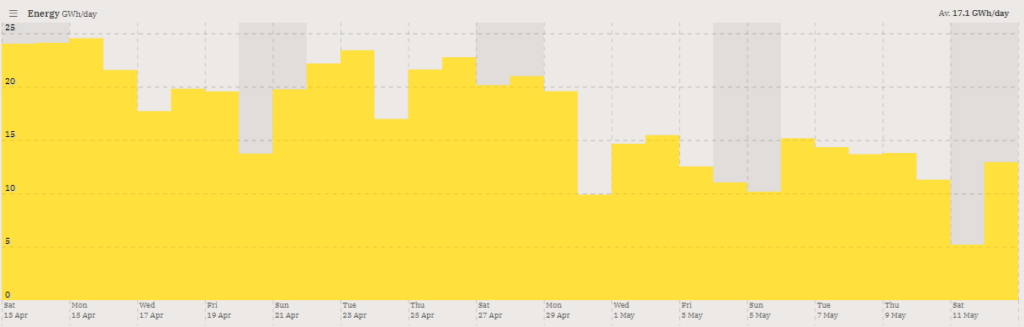
Image: Rooftop solar in NSW for 30 days between Saturday, April 13 and Saturday, May 11 in GWh/day. Source: OpenNEM
The overcast beginning to May was also accompanied by rain most days in Sydney.
- To 9 am Monday, Sydney has seen 13 straight days with 3 mm of rainfall or more, for a running total of 212.8 mm for May 2024. That’s not a record rainy streak, but it’s close.
- The Sydney average for the whole of May is 117.3 mm in records going back to 1859.

Image: Kiama is finally seeing a little sun again after rain every day in May so far. Source: iStock.
Numerous locations further south have seen considerably more rain than Sydney, including:
- Point Perpendicular (at the northern entry to Jervis Bay, about three hours south of Sydney) which had received 392.6 mm to 9 am Sunday, with Monday’s update still to be confirmed after yet more heavy overnight rain
- Kiama (just under two hours south of Sydney) with 366.8 mm to 9 am Monday
- Moruya (four hours south of Sydney) with 246.8 mm to 9 am Monday
But as mentioned, the pattern is finally changing, with the low pressure system sitting off the coast near Sydney making its way out into the Tasman Sea. Sydney should see a dramatic increase in sunshine hours and solar output for at least four days.
Further south, a cold front will impact Tasmania throughout Monday – bringing rain to the state’s west coast and potential showers elsewhere – but the front will have little effect on mainland weather.
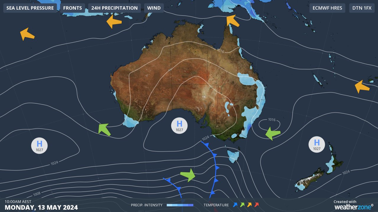
While Melbourne will see a brief drop in daytime temps on Tuesday with cooler mornings on Wednesday and Thursday, conditions in NSW will remain relatively mild for mid-May
The broad ridge of high pressure set to establish itself across southern Australia will put an end to the persistent easterlies which have funnelled moisture onshore for most of May – although the position of the high will increase the chance of showers for the Qld coast from midweek.
Weatherzone Business and Solcast are a market-leading partnership delivering highly specialised solar data to the Australian renewable energy industry. For more information, please contact us at apac.sales@dtn.com.




