

A large pool of abnormally cold water sitting beneath the surface of the tropical Pacific Ocean is a clear sign that El Niño is on its last legs, with history suggesting a swift transition to La Niña could be on the cards in 2024.
The 2023-24 El Niño
The Pacific Ocean has been in an El Niño phase since mid-2023, characterised by abnormally warm water near the surface of the central and eastern equatorial Pacific Ocean.
Based on traditional methods of classifying El Niño, this was a historically strong El Niño and ranked as one of the top 6 strongest El Niño events since 1950. However, there are clear signs that the 2023-24 El Niño has passed its peak.
Sea surface temperature anomalies in the central equatorial Pacific Ocean have been cooling in recent months, dropping from their peak towards the end of last year. There is also a large pool of cooler-than-average water beneath the surface of the tropical Pacific Ocean, showing that the lingering surface warmth is shallow.
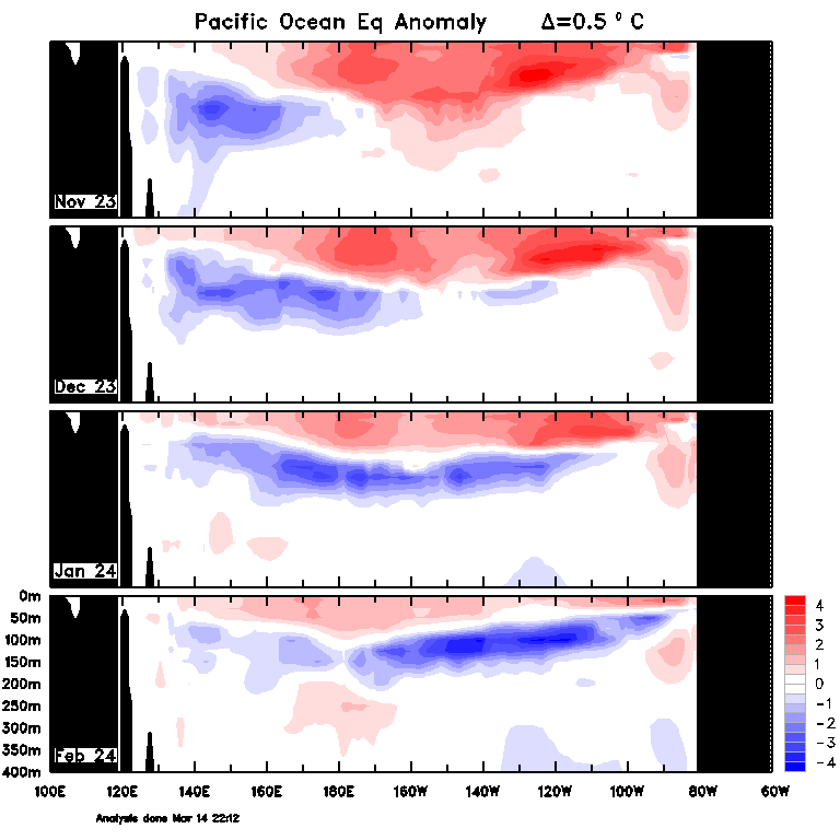
Image: Cross section of monthly ocean temperature anomalies in the top 400 metres of the tropical Pacific Ocean, for the past four months. Source: Bureau of Meteorology
Another sign of El Nino’s demise is the emergence of a process called El Niño discharge in recent months.
All El Niño events go through phases of recharge, maturity and discharge:
- The recharge phase occurs when warmer-than-average water develops below the surface of the tropical Pacific Ocean in the lead-up to an El Niño event, typically over a period of months to years.
- If this deep layer of abnormally warm water gets warm enough and large enough, it can spread to the surface and initiate an El Niño event.
- El Niño’s abnormally warm ocean temperatures causes the surface of the central and eastern tropical Pacific Ocean to rise, putting it out of balance with the surrounding ocean.
- When El Niño reaches maturity, ocean currents start to shift the warm water away from the equator, towards the poles, to restore equilibrium to the tropical Pacific Ocean. This is called the discharge phase of El Niño.
- As warm water flows away from the equator during the discharge phase, cooler water rises towards the surface from deeper depths to take its place.
- If this rising water is cool enough, it can cause a rapid transition from El Niño to La Niña.
History tells us that it is not uncommon for La Niña to occur shortly after a strong El Niño, particularly when the discharge phase of El Niño draws sufficiently cold water to the surface of the tropical Pacific Ocean.
Of the eight other strong El Niño events that have occurred since 1950, five transitioned to La Niña in the same year the El Niño event ended.
Recent observations show that El Niño is currently in the discharge phase of its lifecycle. There is also a large tongue of abnormally cold water below the surface of the tropical Pacific Ocean, which has started to emerge at the surface over the past month.
Video: Daily sea surface temperature anomalies in the eastern tropical Pacific Ocean over the past month. Source: ECMWF / Copernicus Climate Change Service
What’s next for the Pacific Ocean?
With El Niño now in a discharge phase and a healthy supply of abnormally cold water sitting beneath the surface, there is an increasing likelihood of La Niña developing later this year.
Most forecast models suggest that El Niño will officially end in the next few months, with the Pacific Ocean expected to return to a neutral ENSO state (neither El Niño nor La Niña) by May.
Looking further ahead, four of the seven models surveyed by the Bureau of Meteorology predict a transition to La Niña by August, with the rest remaining neutral through the middle of the year.
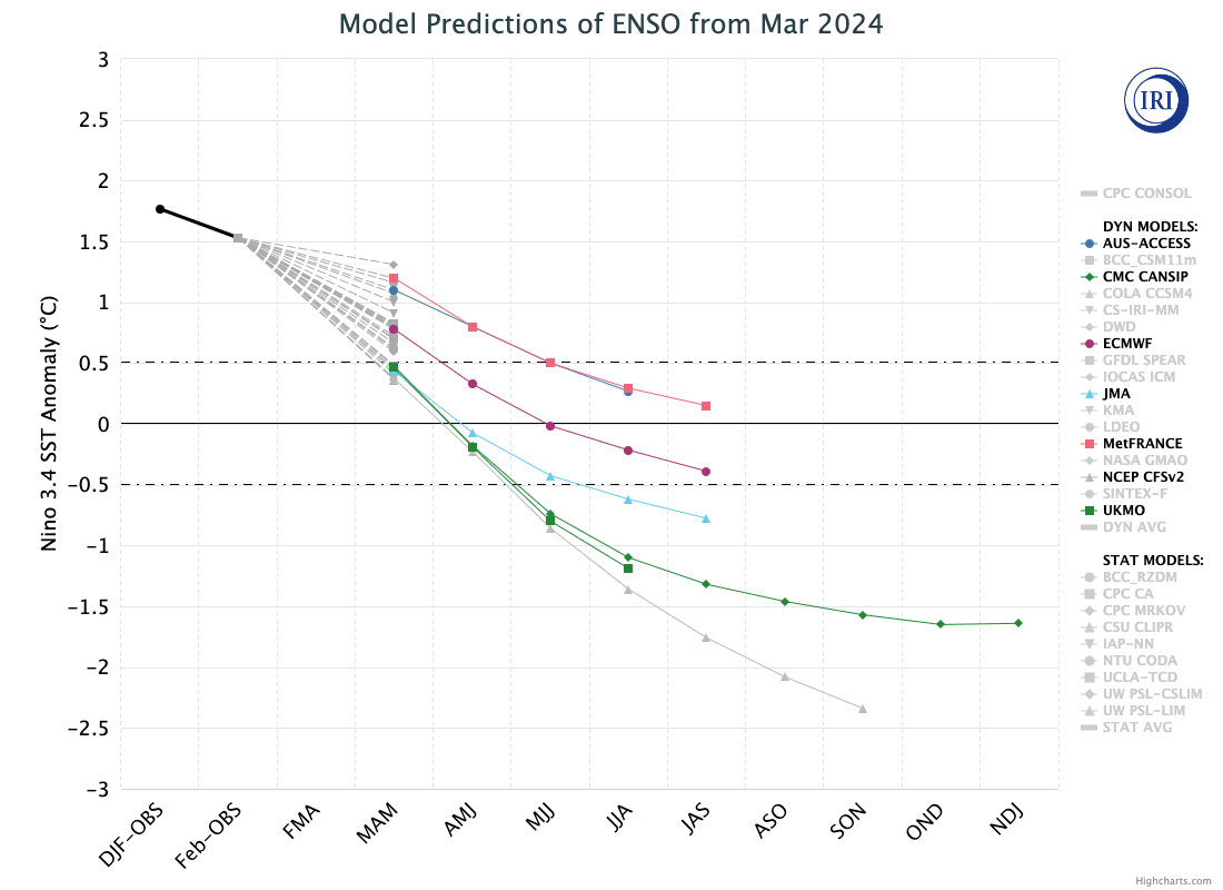
Image: ENSO outlooks from the seven models surveyed by the Bureau of Meteorology. Source: CPC/IRI
It is still too early to know if a La Niña event will occur in 2024, although some of the building blocks required for its development do appear to be falling into place.
For more information on our seasonal forecasts and presentations, please contact us at apac.sales@dtn.com.




