Australia just had its third-warmest and ninth-wettest January on record, which is a remarkable combination.
Ordinarily, you would not expect both above-average temperatures and above-average rainfall to go hand in hand. Simply put, that’s because clouds block direct sunlight, preventing warming.
For example, Australia’s hottest January on record fell in a scorching, sunny summer. That was January 2019, when rainfall was significantly below average in all states and territories.
But in January 2024:
• Australia’s national area-averaged mean temperature was 1.54°C above the 1961–1990 average
• Australia’s area-averaged rainfall total in January was 47.4% above the 1961–1990 average
It’s interesting to note that rainfall and temperatures in January 2024 were not only above average across Australia as a whole, but in all eight states and territories.
That might come as a suprise to residents of Melbourne, where December and January maximum temps were slightly below average as we mentioned in a recent story. https://www.weatherzone.com.au/news/when-will-melbourne-have-real-summer/1766019
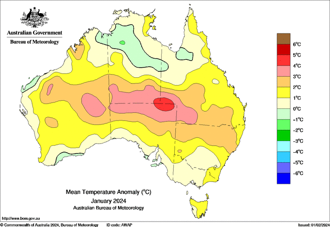
But as you can can see on the chart below, Victoria’s mean (overall 24-hour) temps were actually slightly above average due to a combination of extreme heat in the state’s northwest and warmer-than-usual minimums across the whole state.

Source: Bom
Just as Melburnians might be surprised by the January temperature data, many West Australians will doubtless be taken aback by the fact it was a wet month nationwide.
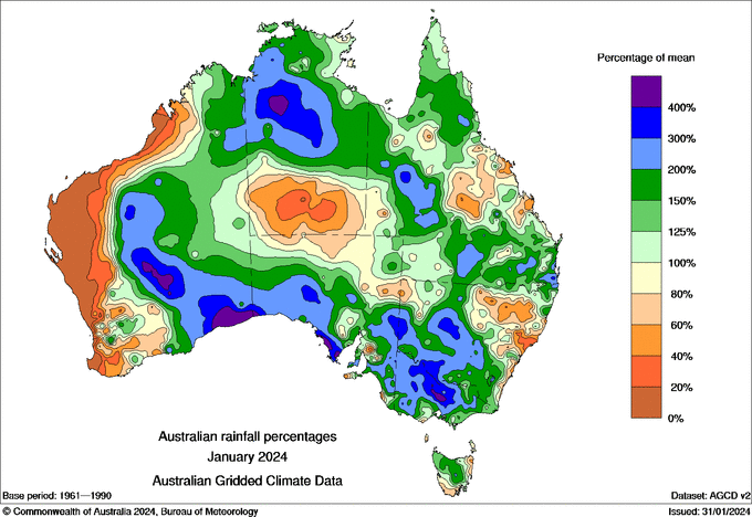
If you look at the rainfall chart below, you’ll see that most of the west coast was parched.

Source: BoM
There were also other parts of the country that had a dry January compared to normal, including parts of central Queensland that missed the action from ex-Tropical Cyclone Kirrily. https://www.weatherzone.com.au/news/extc-kirrily-just-refuses-to-quit/1771881
But Australia is a large country, and when averaged out as a whole, January 2024 was indeed a remarkable month for both warmth and wetness.
To find out more, please visit our website or email us at apac.sales@dtn.com.


