Prosper in a dynamic world
Search

Heavy rain and storms loom for Pilbara


A tropical low will cause heavy rain and thunderstorms across northwestern Australia later this week, with flooding possible in parts of the Pilbara. 

A slow-moving tropical low has caused persistent rain over parts of the NT during the past on to two, producing several hundred millimetres in some areas. Elliot’s 433 mm during the past 12 days was three times its January monthly average. 

The low pressure system has now moved across the border into WA and will continue to spread rain and storms across the state’s north over the next few days. 

Most forecast models suggest the low will move towards the west and soak inland areas of the Kimberley and Pilbara, and parts of the state’s northern Interior. 

Some models predict 50 to 150 mm of rain over a broad area stretching from the southern Kimberley across the North Interior to the southern Pilbara between now and Thursday. Locally intense rainfall due to thunderstorms could produce six-hourly rain rates of 100 to 160 mm. 

However, there is some uncertainty regarding where and how much rain will fall, highlighted by images below. 

Heavy rain and storms loom for Pilbara

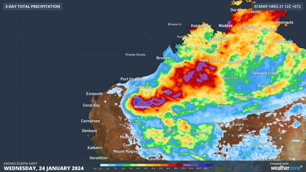
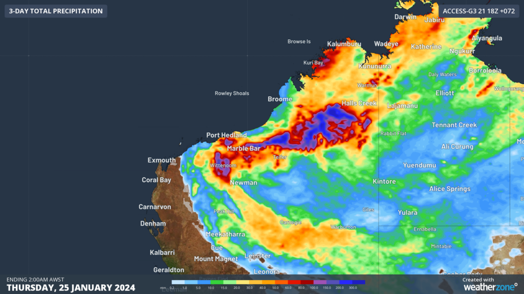
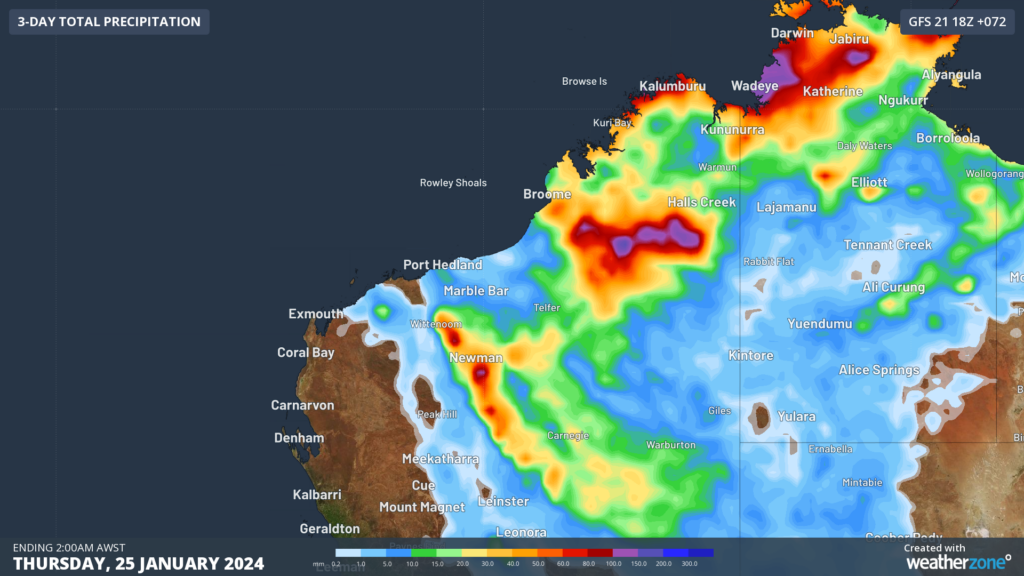
 Images: Forecast accumulated rain during the 72 hours ending on Thursday night, according to the ECMWF-HRES model (top), ACCESS-G model (middle) and GFS model (bottom). 

A severe weather warning and flood watch have been issued for the northern inland of WA in response to this system. Be sure to stay up to date with the latest warnings for the most accurate information on this developing weather event. 

Our Weatherzone clients have access to our lightning and severe weather tracking and alerts, thunderstorm tracking and high precision and site-specific forecasting, along with comprehensive reporting capacity. For more information, please contact us at apac.sales@dtn.com.

Latest news

Satisfy your weather obsession with these news headlines from around the nation, and the world.

Active seas to the north and east of Australia disrupting port and maritime operations

Seas to the north and east of Australia are experiencing periods of increased activity this week, leading to disruptions to port, maritime and offshore operations. Intense and hazardous Tasman Sea Ocean conditions across NSW’s South Coast rapidly deteriorated last Friday as a deep feed of easterly winds whipped up large and dangerous seas. The Batemans […]

Transport, emergency and energy industries flooded across Greater Sydney with weekend deluges

Transport, emergency, energy and port industries in eastern NSW and Sydney were impacted by significant flash flooding with intense and heavy rainfall this weekend. Rainfall rates between 80 and 140mm in one to three hours were registered across parts of Sydney’s Northern Beaches and Central Coast on Saturday afternoon and evening. In some areas, these […]

DTN Dangerous Thunderstorm Alerts in action with severe thunderstorms disrupting Perth industries

Severe thunderstorms impacted southwest WA and the Perth region on Sunday, December 14, 2025, triggering Dangerous Thunderstorm Alerts (DTA) by DTN for industries and businesses in the region. DTN operates Dangerous Thunderstorm Alerts (DTA) which alert businesses and industries to thunderstorms based on intensity and movement. These alerts provide advanced notice of thunderstorms moving into […]

How Australian East Coast port and maritime operations could be disrupted by tropical cyclones over the next two weeks

Port and maritime operations across Australia’s East Coast could be disrupted by increased tropical cyclone activity in the Coral Sea and southwest Pacific Ocean over the next two weeks. Meteorologists reference a large selection of Numerical Weather Prediction (NWP) models to forecast weather. A number of these NWP models are forecasting the development of tropical […]