The Northern Australian Monsoon will arrive over the tropics this week, bringing a possible tropical cyclone, wind, rain, storms, and welcome relief from the oppressive tropical heat and humidity of the last few weeks.
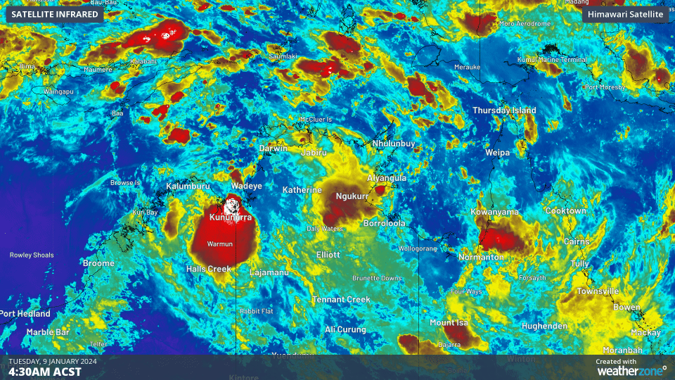
Image: Cloudbands and thunderstorms building around the Top End and Arafura Sea as the monsoon builds.
The monsoon is one of the defining features of a tropical climate and is the primary reason why most of northern Australia receives far more rain than areas in the south. The monsoon is a global-scale wind pattern. Similar to a seabreeze, it is a wind driven by temperature gradients, where one hemisphere (in its winter) will act to cool the other hemisphere (in its summer). Where these cross-equatorial winds converge, the monsoon trough is defined.
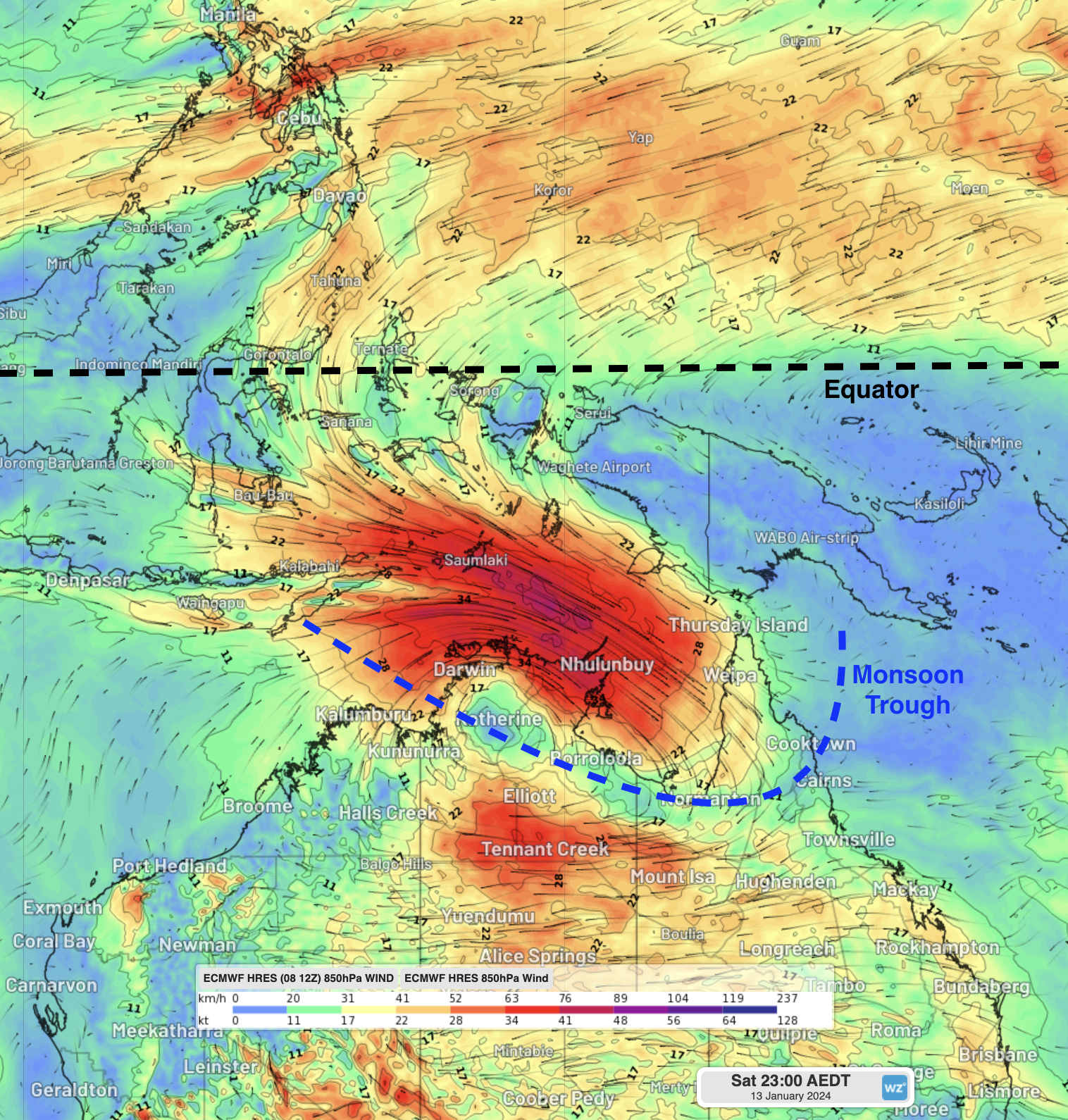
Image: Forecast 850hPa winds from ECMWF showing air from the Northern Hemisphere crossing the equator and converging over northern Australia in the monsoon trough
When the monsoon is active, rain and storms become very frequent, sometimes with a rainband or storm crossing an area every 30-60 minutes for days at a time. Winds and waves also tend to pick up substantially, with sizeable northwesterly swell a hallmark of the monsoon. Finally, the monsoon tends to bring all the ingredients necessary for tropical cyclone development, including moisture, low pressure systems, and low wind shear. Usually, if a low embedded in the monsoon sits over the open ocean for a few days, there is quite a high chance that low will develop into a tropical cyclone.
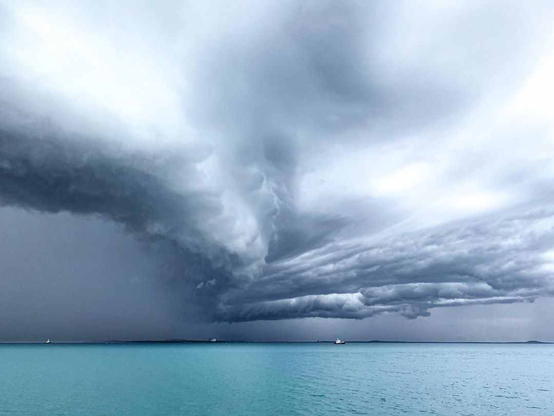
Image: Squally storm in the buildup to the monsoon in 2020. Credit @nath_lew Instagram
The monsoon trough is expected to develop over northern Australia on Thursday, where it is expected to sit over Darwin, bringing relief to one of their hottest starts to a year on record. This is fairly late for the monsoon to arrive, with typical arrival in mid-late December, but this is more typical of an El Niño year. However, it is still two weeks earlier than the latest on record for Darwin: 25th January 1973. This monsoon onset will likely last around 10-15 days.
Earlier this season, a monsoon pulse helped feed moisture into Ex-Tropical Cyclone Jasper and was the main contributor to the record-breaking rainfall recorded in Tropical North Qld. However, this onset will be of a broader scale, and what we would typically expect with a monsoon onset.
Over the weekend, the monsoon will dip further south, with heavy rain expected for the Top End, around Cape York, and stretching into more inland parts of the NT and Qld. Parts of the Kimberley in WA will see the monsoon, but most of these areas will see scattered to widespread thunderstorms on the south side of the monsoon trough.
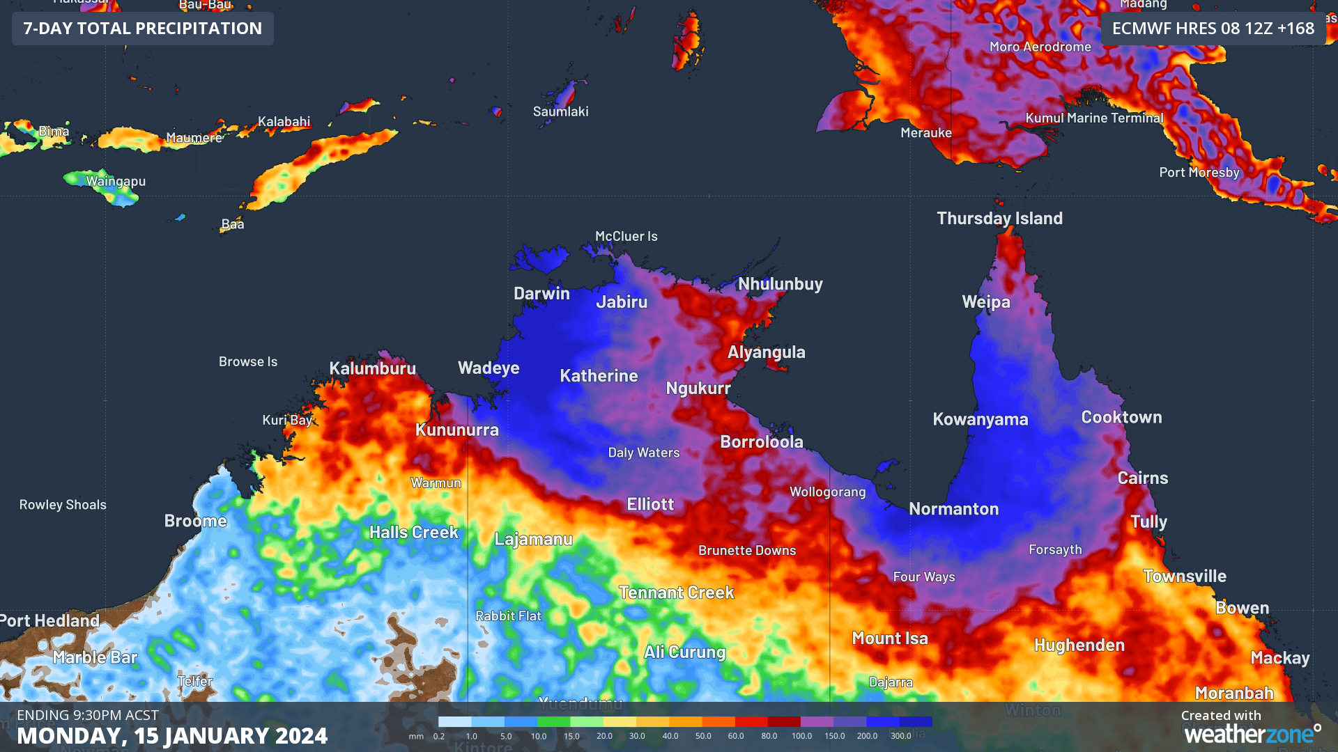
Image: Forecast rainfall over the next 7 days over northern Australia with the monsoon. Areas in the western Top End could see 300-600mm fall, with 200-400mm possible over Far North Qld.
Embedded in the monsoon trough, there will be two tropical lows of note to monitor for tropical cyclone development. The next two names of tropical cyclones developing in Australian waters will be named Kirrily and Lincoln.
The first is developing in the Joseph Bonaparte Gulf just to the west of Darwin. This system is expected to be a moderate chance to develop into a tropical cyclone, most likely on Friday to Sunday. If it does, there is a high chance it will make landfall somewhere between just south of Darwin and Kalumburu over the weekend, although it is possible it could hug the Kimberley coast and impact near Derby. This system is expected to be small, which means it could develop and intensify very quickly.
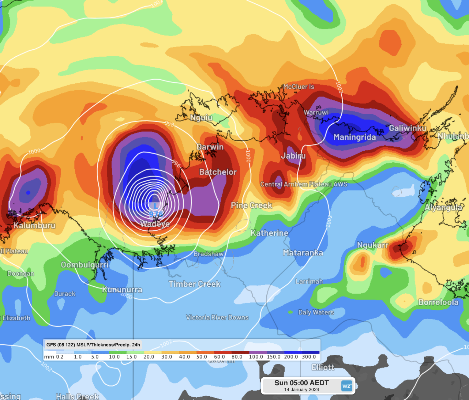
Image: Forecast of this tropical low developed into a tropical cyclone near the western Top End from GFS. Note this is only one models prediction and may change substantially over the coming days
Even if this system does not develop into a tropical cyclone, it will likely form the base of the heaviest rain and strongest winds in the monsoon trough over northern parts of the NT once over land.
The second tropical low is around Queensland, initially starting in the Gulf of Carpentaria. This one could take any number of paths, from lingering and moving around the Gulf, crossing the Cape York Peninsula to develop in the Coral Sea, or simply lingering over land and not developing any further.
While the monsoon and tropical cyclones are a normal part of the northern Australian climate, they can still pose threats of lightning, flooding, wind damage and coastal inundation from storm surges, so keep a good eye on the warnings over the coming fortnight.
DTN APAC has a suite of tropical cyclones services we provide to deliver our clients with as much forewarning of tropical cyclones as we can. We have 4 levels of forecasts timeframes:
- Tropical cyclone seasonal outlooks
- Weekly tropical update
- Daily 7-day tropical cyclone forecast
- Detailed tropical cyclone impacts (issued every 1-6 hours aligning with offical advisories)
Through these products you can have as much preparation as possible for tropical cyclones and their impacts. To find out more, please visit our website or email us at apac.sales@dtn.com.


