
An outbreak of severe thunderstorms is likely to develop over eastern Australia on Christmas Day, with Australia’s three largest cities and the nation’s capital all at risk of wet and stormy weather.
As usual, the weather across Australia on Christmas Day will be a mixed bag this year.
Perth and large areas of western, northern and central Australia are set to have a hot and dry Christmas, while predominantly dry weather is also expected in Adelaide, Hobart and even Darwin.
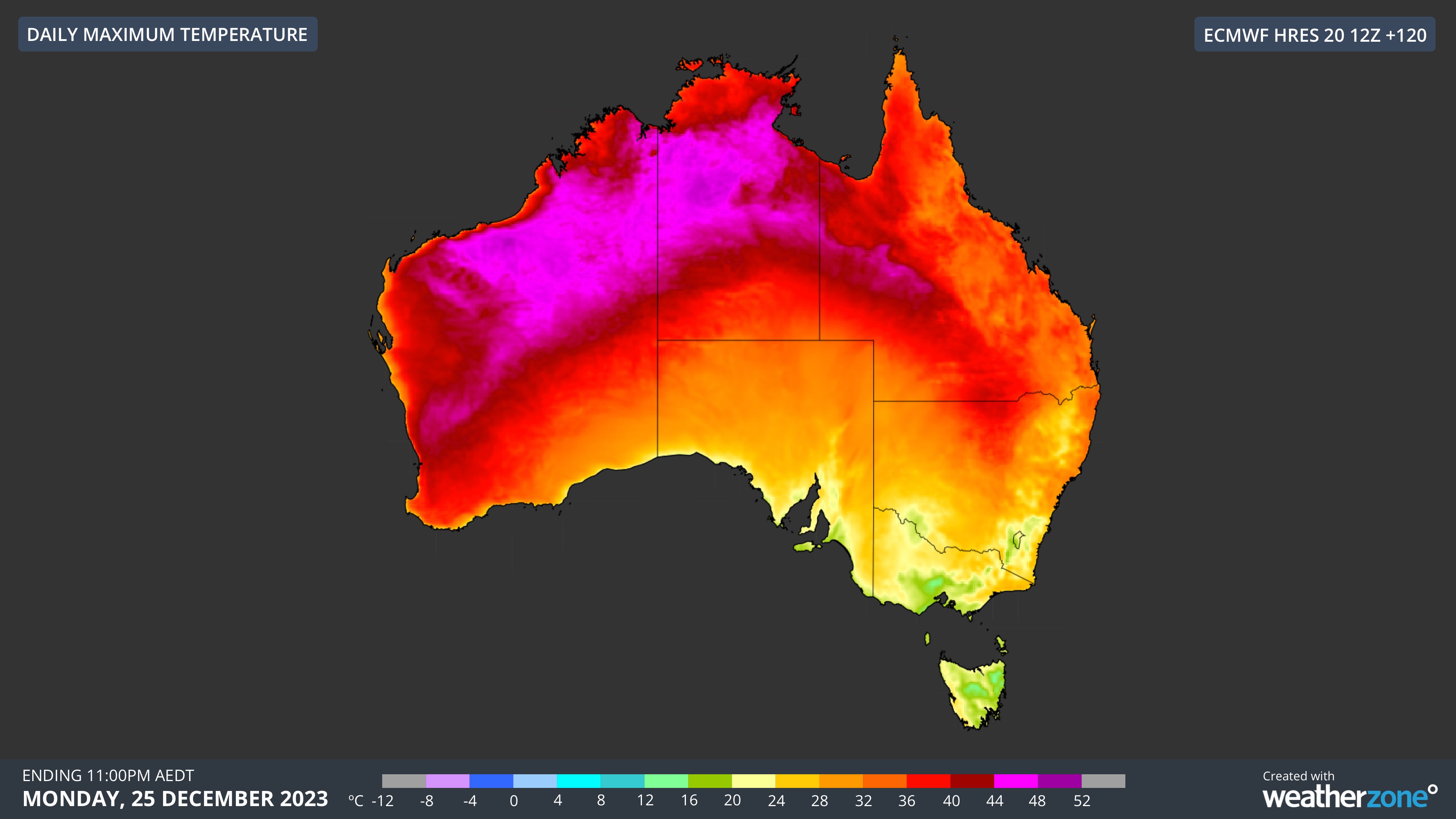
By contrast, showers and thunderstorms are likely to be widespread over parts of Qld, NSW, the ACT and Vic on December 25, possibly including Sydney, Melbourne, Brisbane and Canberra.
Eastern Australia’s stormy Christmas outlook is due to a mix of ingredients that will create an ideal environment for widespread shower and thunderstorm activity:
- A broad low pressure trough being fed by moisture-laden north to northeasterly winds
- A warm, humid air mass in the low levels of the atmosphere interacting with a much colder pool of air aloft, which will create a highly unstable atmosphere
- Dry upper-level air that will aid hail development
- A positive Southern Annular Mode (SAM). This climate driver promotes wet and stormy weather in eastern Australia at this time of year

There is potential for severe thunderstorms over parts of eastern and southeastern Australia on Christmas Day due to the ample instability and combination of moisture-laden air near the surface and much drier air aloft.
The map below shows a measure of atmospheric instability called convective available potential energy (CAPE), which is a tool used by meteorologists to see how much energy is available for developing thunderstorms. Higher values of CAPE mean greater atmospheric instability and more potential for storms to grow.
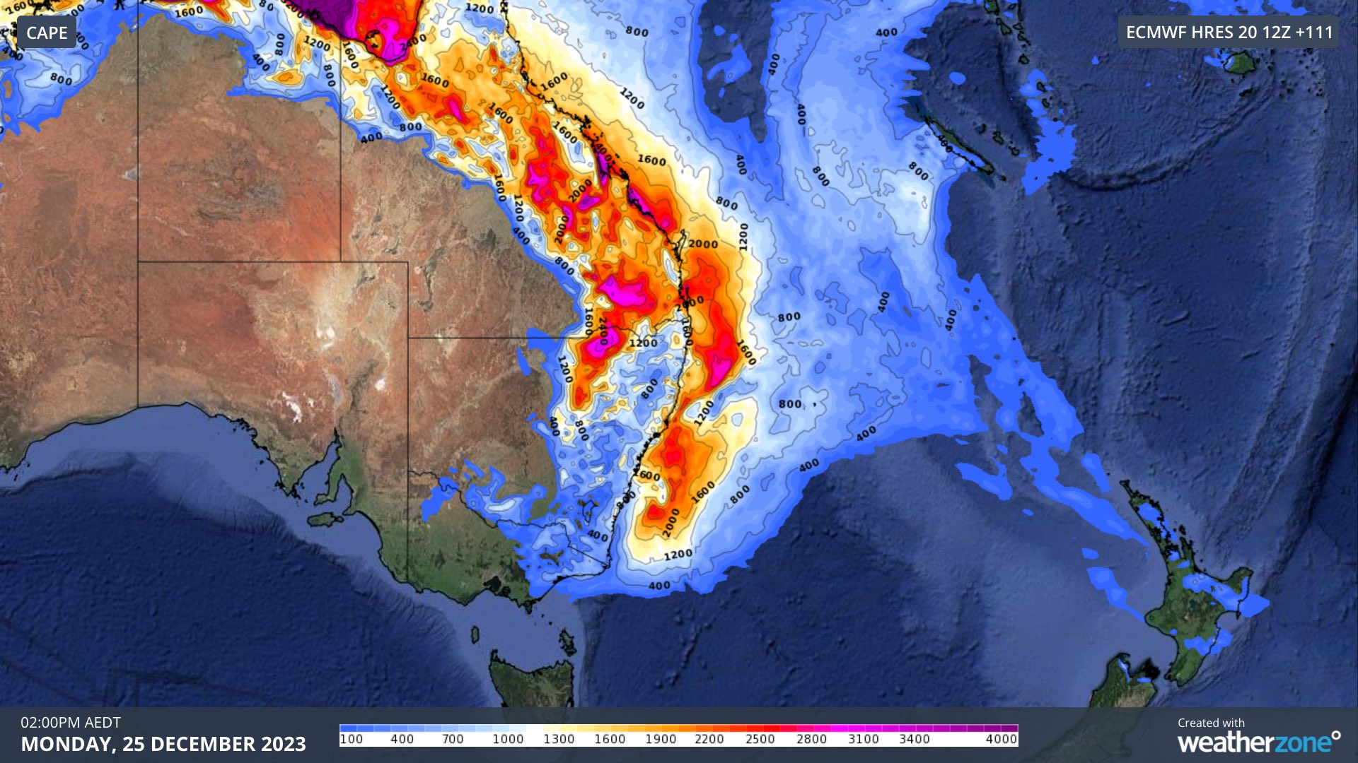
Image: Modelled CAPE at 2pm AEDT on Christmas Day, according to the ECMWF-HRES model.
The image above shows that CAPE values could exceed 3000 J/kg over parts of Qld and northern NSW on Christmas Day, indicating the potential for strong thunderstorms. Any storms that develop in these highly unstable environments could cause large to giant hail, damaging to destructive winds and heavy rainfall.
While CAPE is considerably lower in southern NSW and Vic, these areas may still see severe thunderstorms. One of the main threats with storms that develop in Vic on Christmas Day will be heavy rain, which could cause areas of flash flooding.
Warnings will be issued on Christmas Day if severe thunderstorms develop in any Australian state or territory. So, if you are planning to be travelling or outdoors in eastern Australia, be sure to keep an eye on the radar and the latest warnings.
Weatherzone’s Total Lightning Network is the intelligent solution that goes above and beyond to increase your lead time before the storm hits. We utilise a vast global sensor network, created with our partner Earth Networks. Offering unsurpassed accuracy, with real-time detection to <200m, we integrate with your existing systems to keep your enterprise operating within your defined severe weather thresholds. For more information, please contact us at apac.sales@dtn.com.


