
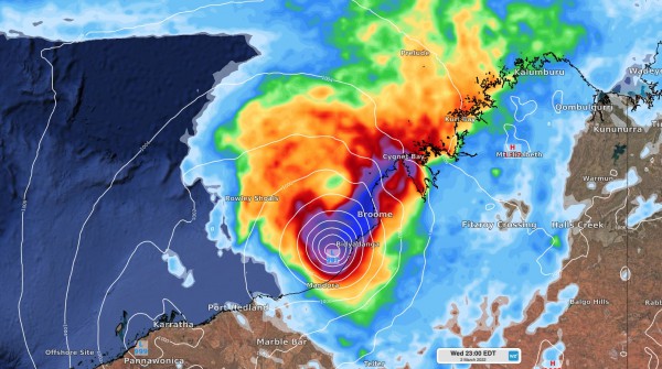
Ex-tropical cyclone Anika is starting to move off Western Australia’s Dampier Peninsula and will soon redevelop into a tropical cyclone near Broome.
The satellite image below shows a mass of cloud encircling ex-tropical cyclone Anika, which is currently located over the Dampier Peninsula.

Image: Visible satellite image showing Ex-Tropical Cyclone Anika over the Dampier Peninsula at 9am AWST on Tuesday, March 1.
Anika will move offshore on Tuesday or early Wednesday morning and will start to intensify once over water.
The images below show where one model is predicting tropical Anika to be located at 8am and 8pm AWST on Wednesday.


Images: Forecast accumulated 24-hour rainfall and mean sea-level pressure at 8am (top) and 8pm (bottom) AWST on Wednesday, March 2.
After re-intensifying on Wednesday, Anika is likely to cross the east Pilbara or west Kimberley coast on Wednesday night or Thursday morning, most likely as a category two system. However, if Anika lingers over water for longer than expected, it could cross the coast as a category three severe tropical cyclone.
Based on its predicted landfall as a category two tropical cyclone, Anika is expected to produce very destructive wind gusts of around 140 km/h near its core as it approaches and crosses the coast. Heavy rain and damaging to destructive winds will also affect a broader area of the west Kimberley and east Pilbara coasts during the next 24 to 48 hours.
Abnormally high tides produced by Anika’s powerful onshore winds could also cause flooding in low-lying coastal areas between Bidyadanga and De Grey on Wednesday night or Thursday morning.
After making landfall, Anika is likely to move inland over northern WA and gradually weaken, which will allow wind and rain to ease near the coast on Thursday. However, heavy rain and potentially damaging winds should spread inland over the East Pilbara and Interior districts on Thursday, likely affecting Marble Bar and Telfer.
The map below shows one models predicted wind gusts on Thursday night, with the strongest winds forecast near Telfer and Marble Bar.

Image: Forecast wind gust speed and direction at 8pm AWST on Thursday, according to the ECMWF-HRES model.
Weatherzone provides extended forecast information with regards to the potential development and then tracking of tropical cyclones out to 7 days. Advisory text by our team of meteorologists delivers bespoke advice on the risk involved and likelihood of development, allowing for suitable preparations to be made. For more information, please contact us at apac.sales@dtn.com.




