
Tropical cyclone Seroja is expected to bring extremely dangerous weather conditions to the west coast during this coming Sunday or Monday 12 April.
Seroja is forecast to make landfall between Carnarvon and Jurien Bay, late Sunday or early Monday morning. The dangerous weather generated by Seroja may also extend further south along the coast to Perth and inland into the Wheatbelt and southern Goldfields during Monday 12 April.
The tropical low near Seroja has now been declared tropical cyclone Odette, with two cyclones now in the mix off the west coast. Tropical cyclone Seroja and Odette are expected to rotate around each other, which is a rare phenomenon called the Fujiwhara effect. Tropical cyclone Odette is anticipated to lose the battle, with Seroja becoming the dominant cyclone, weakening Odette to below cyclone strength.
While it is likely to no longer be classified as a tropical cyclone when Odette nears the coast tomorrow, there is a risk of heavy rain and damaging winds between Exmouth and Coral Bay during tomorrow, Saturday 10 April. By Sunday, 11 April, the system will have weakened and moved away from the coast.
At this stage, Seroja is forecast to cross the coast later Sunday into Monday, between Carnarvon and Jurien Bay. Wind gusts in excess of 90 km/h are likely to develop between Coral Bay and Lancelin from Sunday afternoon and evening (figure 2). The wind gusts are forecast to extend inland to the Wheatbelt and Southern goldfields during Monday, 12 April.
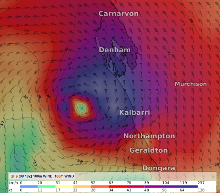
Figure 2: American model 100m winds (indication of wind gusts possible) on Sunday 11th April at 5pm WST
Near the centre of Seroja, wind gusts may be destructive with gusts exceeding 125 km/h as Seroja moves across the coast into the Wheatbelt (figure 2), most likely up to 150km/h.
Near the track of Seroja, very heavy rainfall is forecast during this coming Sunday and Monday. The tides are forecast to be abnormally high, potentially causing flooding between Coral Bay and Lancelin. There is a serious risk of flooding between Shark Bay and Denham due to the high tides.
Safety is one of Weatherzone’s priorities while providing services to businesses. Weatherzone protects assets, equipment and personnel and manage potential health and safety events more effectively.
For more information on our services, please contact us at apac.sales@dtn.com.




