
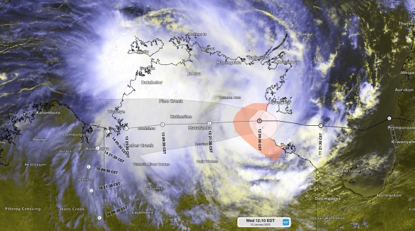
Tropical Cyclone Tiffany made landfall over the eastern Top End on Wednesday morning, with several days of heavy rain now set to inundate parts of the NT and WA.
After crossing Cape Yorke Peninsula earlier this week, Tropical Cyclone Tiffany traversed the Gulf of Carpentaria on Tuesday into Wednesday morning.
While there were signs that Tiffany could reach the Groote Eylandt as a category three severe tropical cyclone, the system moved faster than anticipated and instead arrived at the Top End’s east coast as a category one tropical cyclone on Wednesday morning.
Tiffany made landfall near Port Roper around 9:30am ACST on Wednesday, with winds gusting to around 100 km/h near its core as it crossed the coast.
Similar winds were also observed in Tiffany’s outer rainbands on Wednesday morning, with gusts reaching up to 98 km/h at Ngayawili (Elcho Island), 91 km/h at Ngukurr and 85 km/h at Centre Island as of 11am local time.
Tropical Cyclone Tiffany has also caused heavy rain and thunderstorms over the Top End and its islands during the last 24 hours. This rain and storm activity has come directly from the tropical cyclone, and from an associated Mesoscale Convective System (MCS) that developed ahead of it.

Image: Enhanced infrared/visible satellite image combined with tropical cyclone track map, showing the location of Tiffany at landfall and a large mass of rain and storm-bearing clouds over the Top End.
During the 24 hours to 9am on Wednesday, several rain gauges across the Top End picked up over 80mm of rain, including 127mm at Milingimbi, 81mm at Groote Eylandt, 80mm at Centre Island. Falls of around 50mm were also recorded near and south of Darwin.
Tropical Cyclone Tiffany will now move inland across the Top End and is likely to weaken below tropical cyclone strength later on Wednesday.
However, Tiffany’s remnant low pressure system should remain over the Top End for several days, where it will continue to cause widespread heavy rain and potentially severe thunderstorms.
There is a small chance that the system could move briefly move into the Joseph Bonaparte Gulf, but it is unlikely stay over water long enough to become a Tropical Cyclone.
While heavy rain is guaranteed in the coming days, uncertainty around Tiffany’s future path make it difficult to know exactly where and how much rain will fall.
Below is the forecast accumulated rain between now (Wednesday) and Sunday from three different forecast models. All three models show the potential for more than 200mm during this period, with some predicting over half a metre of rain in places.


Image: Forecast 5-day accumulated rain between Wednesday and Sunday, according to the ECMWF (top), GFS (middle) and ACCESS-G (bottom) models.
At this stage, heavy rain and severe thunderstorms are possible over a broad area of the NT and the northeast of WA during the next 5 to 7 days. This may include Darwin, the western Top End, the Joseph Bonaparte Gulf and the northern Kimberley.
It will also be important to keep a close eye on what happens to the remnants of Tropical Cyclone Tiffany next week.
There are early indications that it could travel south and link up with an upper-level trough to produce heavy rain in Australia southern or eastern states mid-to-late next week. This will become clearer as more model data becomes available in the coming days. For more information on Weatherzone’s Tropical Cyclone and rainfall forecasting, please contact us at apac.sales@dtn.com.




