
Squall lines pose a significant safety threat to offshore oil and gas operations. They also can cause serious damage to business assets as well as halting operations on the rig, decreasing the rigs efficiency.
What are squall lines?
Squall lines are not frequent across the northwest shelf of Australia and the Pilbara coastline, they generally happen further south near or ahead of cold fronts. When they do occur, they can cause a rapid onset of damaging winds, blinding rain and frequent lightning.
A squall line is a long line of thunderstorms, which are typically 10 to 20 miles wide (16-32km) and can reach hundreds of miles (160km+) long. The gap in-between each thunderstorm is small, making it one continuous line of storms. They can arrive at any time of the day and night and their arrival is announced by a dark and ominous shelf clouds (figure 1). Although they can happen at any time of the year, they are most likely during spring and early summer.
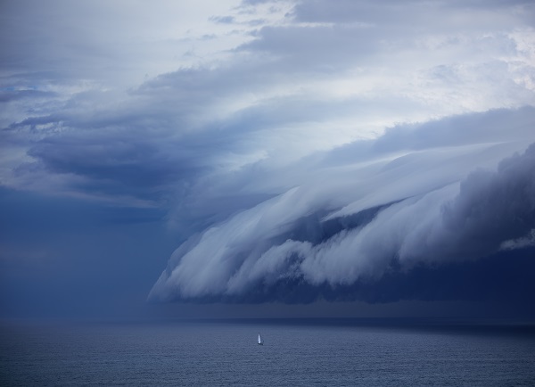
Figure 1: A shelf cloud over the ocean
The size of a squall line is one of the key differentiators between a squall line and singular severe thunderstorm. Single thunderstorms are like ‘popcorn’ and are typically 15 miles in diameter, which is much smaller than the length of a squall line (a line of thunderstorms). Therefore, the risk of a squall line hitting the rig is far greater than a singular storm.
Why are they so dangerous?
The winds associated with a squall line are generally severe and typically exceed 35 knots. In fact, a squall event during 2014 produced sustained winds of 35 knots and gusts of over 50 knots at Langendre Island. The localised damaging winds occur beneath the most severe storms in the squall line.
The strong winds generally increase and decrease rapidly, lasting only several minutes. This is because squall lines move very fast, passing the rig within several minutes. However, the squall line itself can last for hours or sometimes days, marching on to new locations. Their prolonged lifetime is caused by new thunderstorms continually forming on the leading edge of the line.
Lightning and heavy rainfall are two other major hazards associated with squall lines, particularly below the most severe storms in the line.
How do they form, and can we forecast them?
Squall lines need a unique mix of ingredients to form, which can often make forecasting them difficult. However, they form in humid environments and in an atmosphere where winds at the surface are very different to the winds higher up in the atmosphere (vertical wind shear).
Of course, squall lines are obvious on radars for our meteorologists at Weatherzone and squall warnings may be issued on the day. We can also provide Dangerous Thunderstorm Alerts (DTAs), which provide 50% greater lead time on average than other alerts. These severe weather alerts are issued when our total lightning network detects frequent lightning and potentially dangerous conditions.
However, businesses often need more warning than this. Our meteorologists can provide you with a 7-day severe weather outlook and meteorological consultancy. For more information, please contact us at apac.sales@dtn.com.




