
A burst of tropical moisture will cause rain and thunderstorms to spread across Western Australia during the next four days.
The satellite image below shows cloud surrounding a small low pressure system to the northwest of Australia (south of Christmas Island). This low is embedded in a low pressure trough that extends up towards the Timor Sea.

Image: Enhanced visible/infrared satellite image captured at 11am AEDT on Thursday.
The cloud and moisture that is currently sitting to the north of Western Australia will drift further south in the coming days and feed into a low pressure trough. This tropical moisture will bring rain, cloud and thunderstorms to a broad area of Western Australia.
Video: Forecast precipitable water showing tropical moisture bring dragged over Western Australia during the next several days. Data from the ECMWF model.
Rain and thunderstorms will develop over the Kimberely, Pilbara, Gascoyne and North Interior on Thursday.
This wet and stormy weather will continue across the northern tropics and spread further south across the South West Land Division on Friday, and also extend across the Goldfields and South Coastal District on Saturday. Rain and storms will continue over the state’s northwest, Interior and southeast on Sunday and Monday.
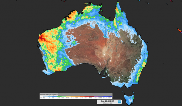
The map below shows which areas are expected to see rain and thunderstorm activity between Thursday and Sunday. Some of the storms from this system are likely to be severe, with heavy rain, damaging winds and large hail all a risk.

Image: Forecast accumulated rain between Thursday and Sunday, according to the ECMWF-HRES model.
This week’s rain follows a relatively dry summer-to-date for much of Western Australia. The red areas in the map below show where rainfall was below the long-term average during December and January combined.

Image: Rainfall deciles during December 2021 and January 2022 combined. Source: Bureau of Meteorology
The lack of monsoon cloud and rain in the state’s tropics during January also produced exceptional heat, with several weather stations in the Pilbara registering Australia’s first 50ºC observations in more than 20 years.
. This included 50.7ºC at Onslow Airport, which is the highest temperature ever reliably recorded in Western Australia and the equal highest temperature on record in the Southern Hemisphere.
Looking ahead, drier weather is set to return to Western Australia next week, however there are indications that the Madden Julian Oscillation (MJO) may move into the Australian region around the middle of the month. This may enhance tropical activity over parts of northern Australia.
Weatherzone provides our clients with detailed heavy rainfall and thunderstorm forecasting, for more information please contact us at apac.sales@dtn.com.




