
Prosper in a dynamic world
Search

Oracle captures the Papua New Guinea storm this week


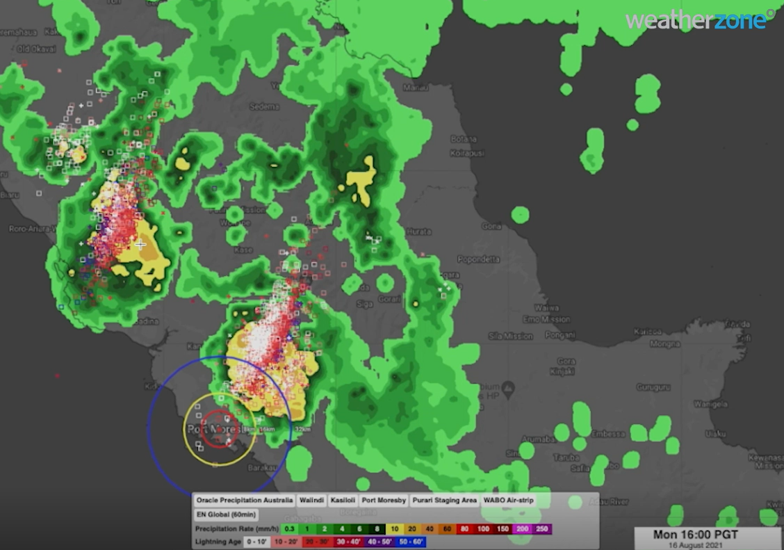
A thunderstorm rolled into Port Moresby, Papua New Guinea from the west on Monday, August 16, with little warning to locals about the Papua New Guinea storm due to sparse radar coverage (figure 1).

Oracle our new ‘radar’ system captured the storm, lightning, and heavy rainfall perfectly, well in advance and before the storm made its way through Port Moresby. 

Our clients in Port Moresby, with Oracle, were warned well in advance of the storm and rainfall, with the ability to track the storm. This enabled our clients to plan and prepare for the storm ahead of time, which is key for safety and productivity.  

Figure 1: Oracle radar capturing lightning and heavy rainfall between 1-4pm PGT on Monday, August 16, 2021.  

The Papua New Guinea storm (figure 1) illustrated the power of the Oracle system; however, it is worth noting this can be deployed anywhere in the world. 

 This storm clearly demonstrated the power of the Oracle system near Port Moresby. However, it is worth noting that Oracle can be deployed anywhere in the world, enabling users to see rain as it is happening wherever they are.  

In addition to tracking current rain, Oracle also provides live forecasts of rainfall rates, lightning, and cloud for up to three hours in advance, for anywhere in the world. 

It does this by feeding live satellite imagery, lightning data and nearby radar imagery into the forecast system. This innovative technology was built in collaboration with Solcast.  

Oracle is a more than adequate replacement for radar, but the genius of it is that it’s also a one-of-a-kind forecast system, delivering accurate forecasts out to four hours.  

Stay tuned for additional updates on Oracle’s new forecasting capabilities. For more information, please contact us at apac.sales@dtn.com.  

Latest news

Satisfy your weather obsession with these news headlines from around the nation, and the world.

Signs of a positive Indian Ocean Dipole, but it may not follow the textbook

Waters off Indonesia have cooled in recent weeks, an indication that a positive Indian Ocean Dipole (IOD) event could be developing. It’s an important climate driver for Australia, and it could shape rainfall and temperatures heading into summer, with flow-on effects for farmers, energy and other industries.  What is the Indian Ocean Dipole?  The IOD […]

1.3 million lightning strikes and a record September downpour: the storms testing WA’s Goldfields

Leonora, WA, had its wettest September day on record earlier this month. Three weeks later, more than 1.3 million lightning pulses were detected within 800 km of the town in 48 hours. Why is a stalled trough delivering storms to mining country, and what it could mean for operations?  The DTN Total Lightning Network detected […]

A very low wind power week, likely to continue

A stubborn blocking high over southern Australia will make for a very quiet week for wind generation and the pattern behind it isn’t a one-off.   It’s the seasonal signature of a super (very strong) El Niño combined with a positive Southern Annular Mode (SAM), and both the historical record and the current seasonal forecast suggest it’s likely to keep recurring through spring before a potential switch from November.  The setup right […]

Fastest strengthening El Niño on record: Impacts on Australian monsoon timing and wet season planning

Australia’s Mining and Resources sectors are bracing for a wet season shaped by one of the most rapidly developing El Niño events on record.    Looking back at how the strongest El Niño events in Australian history have played out, it becomes apparent that mining operations in Australia should be planning for a later monsoon […]


