
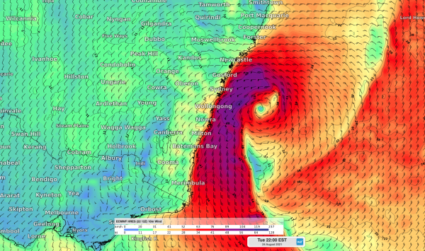
A cold front and intense low-pressure system will cause a dangerous mix of heavy rain, thunderstorms, damaging winds and large waves in eastern NSW during the next 48 hours.
The satellite image below shows clouds passing over NSW near and ahead of an approaching cold front at midday on Monday. These clouds are causing rain, which is heavy in some areas, and thunderstorms.
Behind this cold front, a broad region of speckled clouds can be seen developing within a mass of much cold air that’s spreading over Australia from the south.
The cold front will continue to fuel rain and thunderstorms as it spreads over northeast Victoria, NSW, the ACT and southern Queensland on Monday.
After traversing eastern Australia, the cold front will then move over the Tasman Sea on Tuesday and cause a low pressure system to rapidly deepen near the central coast of NSW.
This deepening low will cause a dangerous mix of wind, rain and surf along the southern half of the NSW coastline on Tuesday and Wednesday.
Some models suggest that the impending low could become a ‘bomb cyclone’, which means its centre deepens by at least 24 hectopascals in 24 hours. Bomb cyclones are known to cause a rapid onset of severe weather.
Damaging winds
A strong and gusty southerly change is expected to move its way up the NSW coast during Monday night and Tuesday morning with the strong cold front.
Wind will strengthen and tend southwesterly on Tuesday as the low-pressure system rapidly deepens over central NSW coastal waters
Sustained west to southwesterly winds are likely to exceed 25 knots (about 46 km/h) during Tuesday and Wednesday at Port Botany and Kembla (figure 1). The strongest winds and gusts are likely to occur between Tuesday and Wednesday afternoon.
While Newcastle’s winds are not as strong as the ports further south, sustained wind speeds are likely to reach 20- 25 knots (37-46 km/h).
Wind gusts at Port Botany and Kembla may reach up to 50 knots on Tuesday and Wednesday, while Newcastle’s gusts may reach 40 knots. Most of these wind gusts are likely to be from the southwest, however showers and thunderstorms could cause variable wind directions and speeds.
While damaging winds are likely near the coast, the strongest winds from this system will occur at least several kilometers offshore near the deepening low pressure system.
Swell
The deepening low pressure system will also cause wave heights to increase rapidly on Tuesday and Wednesday.
Wave heights could reach around 3-5 metres along the southern half of the NSW coast, which has prompted a hazardous Surf warning for coastal waters from the Hunter down to the Victorian border.
The combination of large waves and high astronomical tides near a full moon could cause some localised coastal inundation and beach erosion, particularly along south-facing beaches.
Rain and Thunderstorms
Warm and humid air ahead of the cold front has been generating widespread rain and isolated thunderstorms across NSW on Monday. The rain and storms have moving rapidly from west to east, driven by strong pre-frontal westerly winds.
This rain and storm activity is likely to continue into Monday evening as the front continues to move towards the Tasman Sea (figure 3).
A southerly change moving up the NSW coast Monday night and early Tuesday morning is likely to be a focus for thunderstorm development. The gusty southerly and associated thunderstorms are likely to approach Sydney just after midnight tonight.
The rain is likely to continue throughout Tuesday with 50-80mm predicted for parts of the Sydney and Illawarra coastline (figure 3).
Looking ahead, the low-pressure system is likely to move away from the NSW coast on Wednesday, allowing conditions to improve in the middle of the week.
Weatherzone provide ports around Australia with 7-day forecasts of wind, swell and thunderstorms, which enables our clients to plan in advance. For more information, please contact us at apac.sales@dtn.com.




