

A negative Indian Ocean Dipole (IOD) has been declared this week, which is likely to have an impact on Australia’s weather during the reminder of winter and into spring.
This week’s mean IOD value to July 18 is minus 0.62, which is below the negative IOD threshold of minus 0.4.
As it turns out, the weekly mean IOD value has now remained below the negative IOD threshold for eight out of nine weeks.
This is the first time we have seen a full-blown negative IOD since 2016. That year produced Australia’s second wettest winter on record and the tenth wettest spring for Victoria and Tasmania.
What are the major impacts of a negative IOD, again?
- Above average winter and spring rainfall across parts of southern Australia.
- Increased cloud cover, northwest cloud bands and reduced solar output.
- Below average maximum temperatures across southern Australia during winter and spring.
- Above average minimum temperatures across Australia, due to cloud trapping warmth in overnight.
- Extreme cold days are more likely across southeastern Australia, while extreme cold nights are less likely.
- Above average snowfall during winter and spring.
How long will the negative IOD last?
Many seasonal computer models indicate that a negative IOD will persist through winter and into spring.
Of the five global climate models surveyed, four are predicting the negative IOD to continue through until mid-spring, with most models forecasting that conditions will return to neutral by December.
A recap on what a negative IOD is.
The IOD is a large-scale circulation that occurs in the Indian Ocean, much like the El Niño Southern Oscillation (ENSO) in the Pacific Ocean.
The IOD is characterised by remarkably different sea surface temperatures in the western tropical Indian Ocean (near the Arabian Sea) and the eastern tropical Indian ocean (off the northwest shelf of Australia) (figure 2).
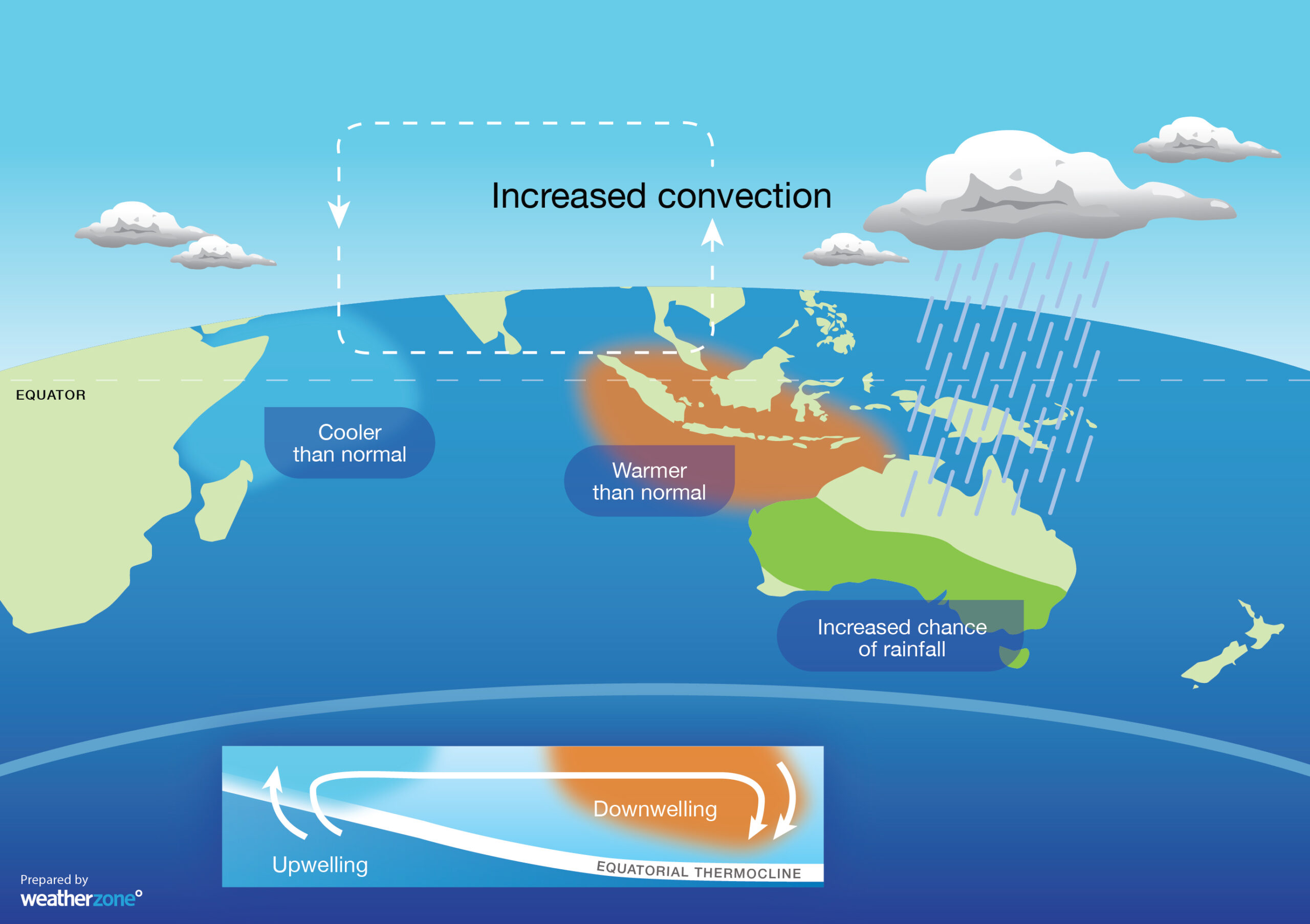
Figure 2: Typical Sea surface temperature pattern and weather impacts during a negative IOD.
When this sea surface temperature gradient is large enough across the Indian Ocean, it drives rising and descending moisture and air on both sides of the Indian Ocean basin (figure 2).
There are 3 phases of the IOD: negative, neutral and positive. Each phase dramatically impacts Australia’s weather. In general, negative IOD events are cool and wet for Australia, while positive IOD events are drier and warmer.
Will the negative IOD combine forces with a La Niña event later in the year?
This week’s declaration of a negative IOD comes as computer models continue to show potential for La Niña later in the year.
Around three out of seven models currently predict that La Niña thresholds will be met by October or November. These signs prompted the US Climate Prediction Centre to issue a La Niña Watch earlier this month, indicating a two-thirds chance of one occurring this year.
When a negative IOD and La Niña occur in the same year, it further increases the likelihood of above average rain for most of Australia.
The last time we saw both climate drives in the same year was 2010, which became Australia’s third wettest year on record at that time.
So, while it is too early to know whether this year’s negative IOD will team up with La Niña, it is worth keeping a close eye on how the Pacific Ocean develops in the next few months.
It’s also worth pointing out that a negative IOD and La Niña don’t guarantee above average rain. Some places can still have abnormally dry months or seasons when these climate drivers are in place, although above-average rainfall is more likely.
For more information on the negative IOD and La Nina and their impacts, please contact us at apac.sales@dtn.com.




