
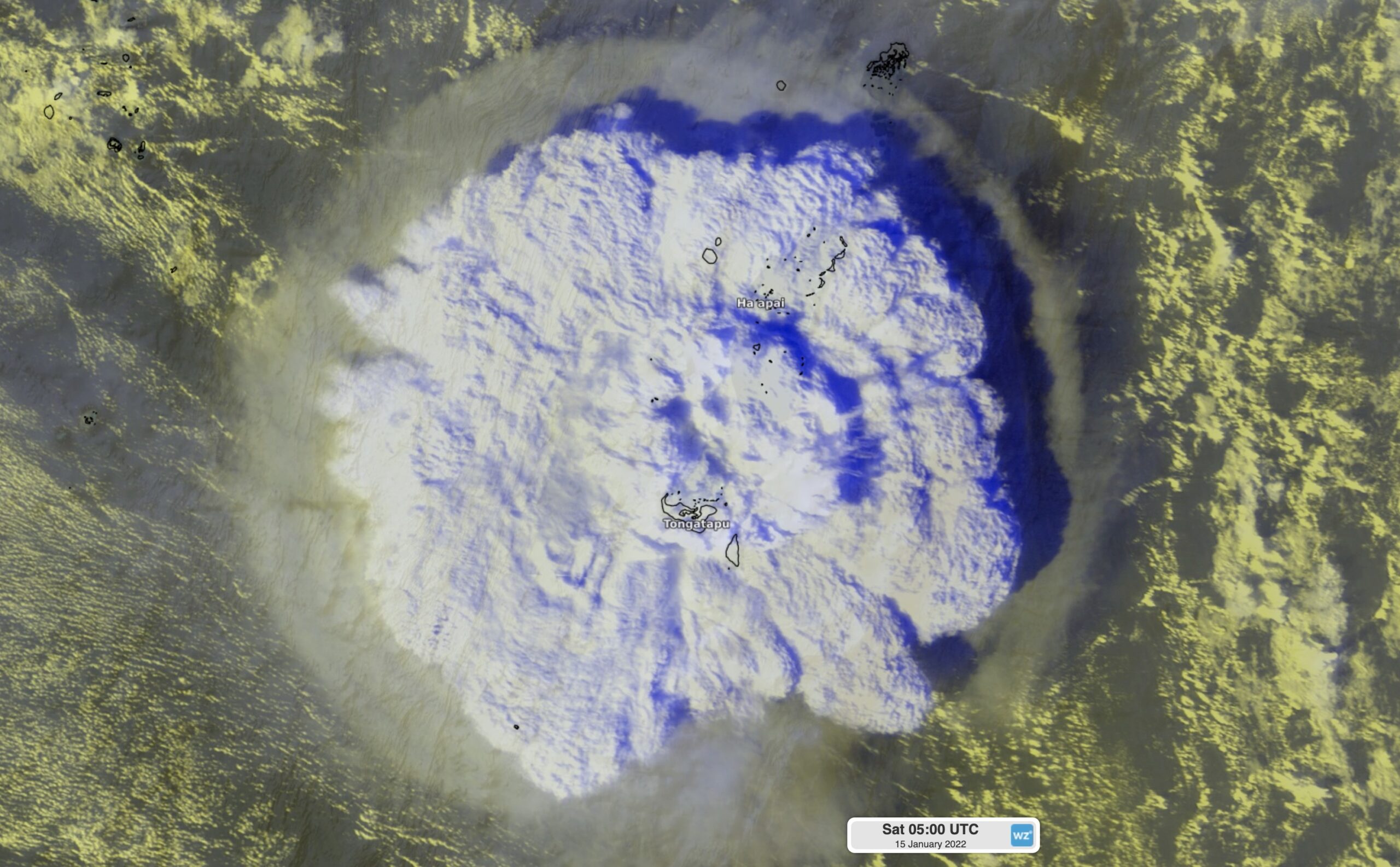
Tsunami waves have been observed in eastern Australia over the last two days following the eruption of an underwater volcano near Tonga on Saturday.
So, how big were the tsunami waves and how rare are tsunamis in Australia?
The Hunga Tonga–Hunga Haʻapai volcano erupted shortly after 3pm AEDT on Saturday, January 15. The explosive eruption sent a plume of gas and ash thousands of metres into the air and sent a shockwave around the world.
Video: Enhanced visible/infrared satellite images showing the eruption of the Hunga Tonga–Hunga Haʻapai volcano on Saturday afternoon.
The volcano was so powerful that it sent atmospheric pressure waves and tsunami waves rippling around the planet.
Air pressure fluctuations were observed at weather stations around the world as the volcano’s shock wave raced through the atmosphere at around 1,200 km/h. The graph below shows the pressure wave reached Sydney around 6:30pm AEDT, around three hours after the eruption, and then Perth another three hours later, at about 6:30pm AWST.


Image: Mean sea level pressure observations at Sydney (top) and Perth (bottom) on Saturday, January 15.
In addition to the atmospheric pressure wave, the Hunga Tonga–Hunga Haʻapai volcano also produced tsunami waves that radiated out across the Pacific Ocean.
What is a tsunami?
A tsunami, which is a Japanese word meaning harbour wave, is a series of waves that can cause coastal inundation and devastation as they hit land.
Tsunamis can be caused by earthquakes, landslides and volcano eruptions, which can all create major disturbances in the ocean. The sudden movement in the water column caused by this disturbance can generate fast moving waves that can travel thousands of kilometres through the ocean.
Tsunamis are different to your average wind driven waves. Tsunamis involve the movement of water from the surface to the ocean floor, giving them immense power and speed. By contrast, normal waves are driven by the wind and only affect the area near the surface of the water.
Tsunamis typically occur near subduction zones where earthquakes and volcanos are most likely to occur. Because Australia sits in the middle of a tectonic plate, away from these subduction zones, tsunamis typically have to travel long distances to reach mainland Australia. This gives Australia’s tsunami detection network plenty of time to warn for oncoming tsunami waves.
Around 77 percent of tsunamis are caused by earthquakes and only about six percent are produced by volcanoes. This makes the weekend’s tsunami quite rare. The remaining tsunamis come from landslides, meteorological events and unknown sources.
How big was the weekend’s tsunami?
A number of sea level gauges in the Pacific Ocean and along Australia’s eastern seaboard detected tsunami waves during the last 48 hours.
According to the Bureau of Meteorology, wave heights reached:
- 1.27 metres at Norfolk Island
- 1.19 metres at Nuku’Alofa in Tonga
- 1.18 metres at Port Villa in Vanuatu
- 1.14 metres at Jackson Bay in New Zealand
- 0.82 metres at the Gold Coast in Queensland
- 0.43 metres at Coffs Harbour in New South Wales
- 0.33 metres at Burnie in Tasmania
There have been media reports of tsunami waves inundating low-lying coastal areas in Tonga as the tsunami came ashore, while dangerous and unpredictable tides have also been observed along parts of Australia’s east coast.
The image below shows continuous water level fluctuations in Sydney Harbour from Saturday evening into Monday morning.

Image: Water level observations near Middle Head in Sydney Harbour. Source: Manly Hydraulics.
How rare are tsunamis in Australia?
On average Australia sees one tsunami in every four years, with over 50 tsunamis observed since European settlement.
Western Australia has seen a number of large tsunamis in recent decades. In 2006 and 1994, tsunami waves that originated near Java, Indonesia travelled around 200-300 metres inland over the state’s Pilbara and Gascoyne districts. The 2006 tsunami inundated several camp sites and washed a vehicle 10 metres up the beach.
Another powerful tsunami in 1868, which originated near Chile, caused boats to wash ashore near Newcastle in NSW and a jetty to wash away at Long Bay, Tasmania.
No two tsunamis are the same and it’s difficult to know how they will impact the coast until they arrive.
In Australia, there are two types of tsunami warnings:
- Marine tsunami warning – these are issued when dangerous waves, rips and strong currents are expected. This can pose a risk to anyone in the water and pose a risk of flooding along the immediate foreshore.
- Land tsunami warning – these are issued when major land inundation is possible, which can lead to flooding of low-lying coastal areas, along with dangerous waves and unpredictable currents.
Land tsunami warnings are rare, but when they do occur the impacts can be extremely dangerous and life threatening.
Visit https://reg.bom.gov.au/tsunami/ for the latest tsunami warnings in Australia. For more information on Weatherzone’s forecasts and services for ports around Australia, please contact us at apac.sales@dtn.com.




