Prosper in a dynamic world
Search

Powerful waves to impact port operations

Deceptively powerful surf is forecast this weekend, as heavy waves originating from the Southern Ocean hit the coastline.  

The heavy surf will be whipped up by a low-pressure system sweeping across the south of the continent later this week. 

The map below shows wave heights of 3-4m are expected across the central and southern NSW coast on Friday and Saturday. 

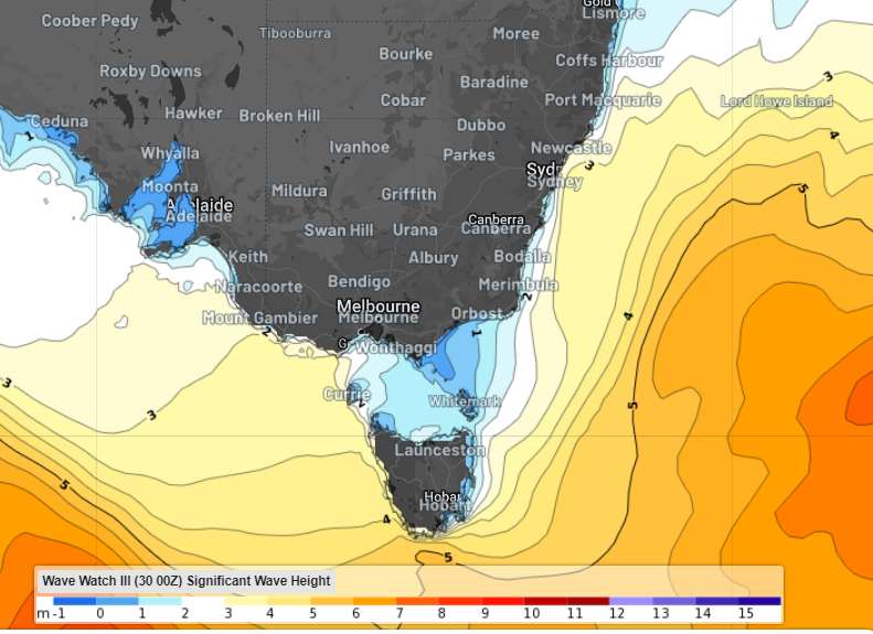
Image: Significant wave height forecast at 5pm Saturday, February 3 according to Wave Watch III 

The image below shows the wave height forecast off the waters at Sydney for the next 5 days, showing the waves peaking at 4 to 4.5 metres on the weekend.

Image: Significant wave height (blue) and Hmax forecast (black)  

These wave heights will create very rough seas off the Sydney and Illawarra coasts on the weekend.  

While the waves will be large, it’s the wave period that will generate the deceptively powerful surf. 

Wave period is the average time between crests (or troughs) of waves. The larger the time difference, the greater the amount of energy associated with the waves or swells. 

The wave period should reach 10-12 seconds along the Sydney coast and south on Saturday. 

The map below shows the high period waves impacting the central and southern coastline on Saturday.   

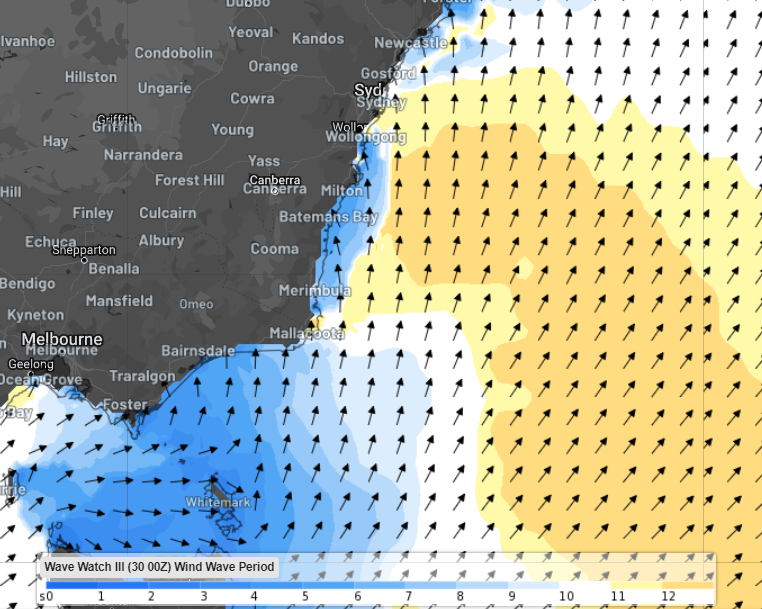
Image: Wind wave period at 4pm on Saturday, February 3, according to Wave Watch III 

Looking ahead, the long period swell should move offshore by Monday.

DTN APAC offers a comprehensive suite of services, refined through years of collaboration with the marine, ports and offshore industries, to optimise the safety and efficiency of your operations.

We work with you to understand your intrinsic operational challenges and customise high-precision forecasting, metocean and aviation services to your exact location and operational scope. For more information, please contact us at apac.sales@dtn.com.

Latest news

Satisfy your weather obsession with these news headlines from around the nation, and the world.

From Kimberley to northern NSW: Bushfire outlook flags risk for resources sector this winter

Bushfire risk doesn’t usually make headlines in June, but AFAC’s winter seasonal outlook is putting mining and resources operators on alert from the Kimberley to the NSW.  Australia’s official seasonal bushfire outlook for winter 2026 was released by AFAC on Thursday, May 28. The outlook predicts increased fire risk across the northern parts of the Great Sandy Desert and surrounds […]

The signal was there weeks earlier: forecasting one of the year’s biggest wind events

In mid-May 2026, DTN APAC meteorologists flagged a strengthening Southern Ocean pattern in model guidance, signalling an extended run of record-challenging wind conditions across the NEM.  Nearly three weeks later, NEM wind generation climbed from around 1.5GW to more than 9GW, supplying roughly one-third of the grid and coming within 1GW of the all-time generation record.  The event highlighted […]

The 2026 Indian Southwest Monsoon onset is expected in the next two weeks

The Indian Southwest Monsoon will reach India in the next two weeks, but a developing El Niño could signal a drier than normal monsoon for businesses and major industries across the country. Southwest monsoon onset over southern India in the next two weeks The Indian Meteorological Department (IMD) is responsible for tracking the advance and […]

Rapid El Niño signal accelerating risk for Australian businesses

El Niño–favourable conditions are gathering pace across the tropical Pacific, with key ocean indicators approaching threshold levels and early atmospheric responses emerging.  While uncertainty remains around final El Niño strength, historical analogues show that even weak events can generate widespread impacts, including reduced rainfall, warmer daytime temperatures, increased frost risk, elevated fire danger, reduced tropical cyclone activity, and more. Industries including […]