
Widespread rain and thunderstorms will spread over Australia’s eastern inland over the next few days, before drenching already sodden parts of the NSW coast this weekend.
The atmosphere above eastern Australia is being loaded with moisture this week thanks to the influence of a stubborn high pressure system centred to the south of the country.
Over the next few days, a pool of cold upper-level air will pass over Australia’s southeast and cause some of the moisture in the atmosphere to be converted into rain. If the atmosphere is like a sponge laden with water, the passage of the cold upper-level air is like someone squeezing the water out of the sponge.
The animation below shows these two key ingredients interacting over the next few days. The blue and pink colours show precipitable water in the atmosphere, which represents how much moisture is available to convert to precipitation. The white lines show an upper-level low passing over the southeast of Australia, which is associated with a cold pool of air around 6 km above sea level.
Video: Composite precipitable water and 500 hPa height contours between Wednesday and Sunday this week, according to the ECMWF-HRES model.
Showers and thunderstorms will start to develop over Australia’s eastern interior on Wednesday and become more widespread on Thursday, affecting areas of western NSW and Qld, the northeast of SA and the southern NT.
This rain and thunderstorm activity will then spread further east across NSW, southern Qld and parts of Vic from Friday to Sunday, under the influence of the upper-level low.
Large areas of western NSW and parts of northern Vic and southern Qld could see 20 to 40 mm of rain from this system, while some areas in western NSW should see 50 to 80 mm.
There is also potential for heavy rain and flooding in parts of eastern NSW on the weekend as rainfall rates increase along the coast, pouring more water into already saturated coastal catchments. At this stage, the area most likely to see flooding rain on the weekend will be the Illawarra and South Coast regions, where 2-day totals of 150 to 250 mm are possible, although this may change in the coming days.
The map below shows how much rain one computer model is predicting for eastern Australia over the coming week, with most of this rain expected to fall between now and Sunday.
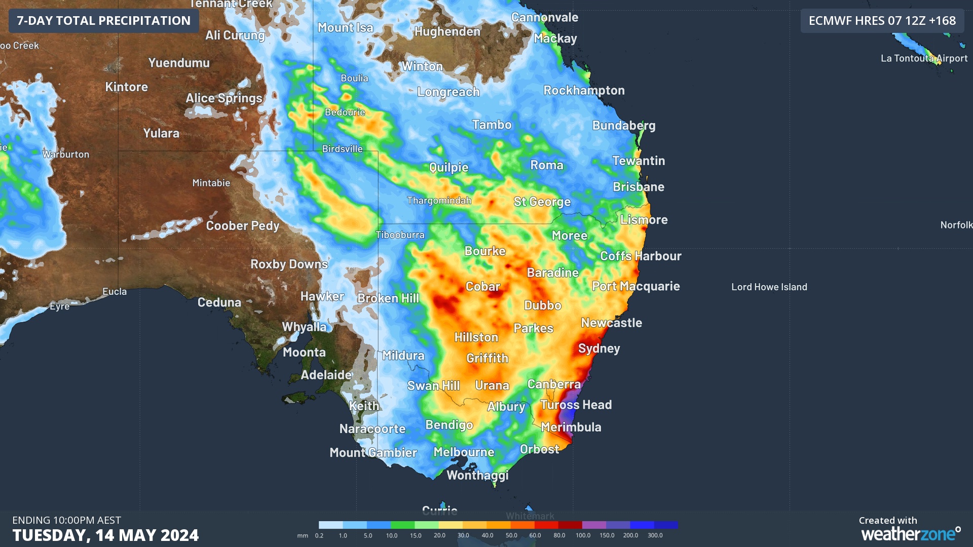
Image: Forecast accumulated rain during the seven days ending on Tuesday, May 14, 2024, according to the ECMWF-HRES model.
Severe weather and flood warnings will be issued closer to the weekend if computer models are still indicating this flood risk later in the week. Be sure to check the latest forecasts and warnings in your area over the coming days for the most up-to-date information.
DTN APAC, a DTN company, specialises in building customised weather monitoring and alerting solutions. These guide transport operators to plan and respond effectively. We tailor our data and analytics to your exact requirements. We support you whilst conducting a thorough
assessment of your weather and environmental monitoring as well as forecasting requirements. This identifies how weather impacts your network and where improvements can be made. You can then choose tailored solutions to boost your operational efficiency and profitability. For more information, please contact us at apac.sales@dtn.com.


