
As parts of eastern Australia brace for yet another multi-day deluge, many flood-weary communities may be wondering when the La Niña tap will turn off.
More heavy rain in NSW
March was marked by record breaking rainfall and catastrophic flooding for parts of eastern NSW. This week, more heavy rain is on the forecast as a low pressure trough stalls over the state during the next four days. This week’s drenching will begin in the Illawarra, South Coast and eastern parts of the Southern Tablelands districts on Wednesday, before extending to Sydney, and parts of the Hunter and Central Tablelands on Thursday.
During the next four days, totals of 100-150mm are possible along the central and southern coast and ranges in NSW, with some areas likely to exceed 200mm. Six-hourly rainfall totals should reach 60-100mm in some areas between Wednesday and Friday, with coastal areas possibly reaching up to 140mm.
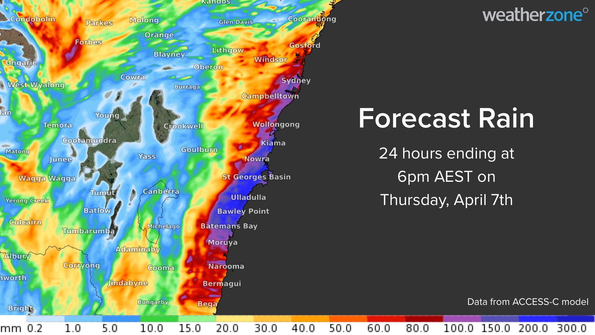
The map below shows one computer model’s prediction of how much rain will fall during the 24 hours ending at 6pm AEST this Thursday.

Image: Forecast accumulated rain during the 24 hours ending at 6pm AEST on Thursday, April 7, according to the ACCESS-C model.
Lingering La Niña fuelling rainfall
This latest bout of heavy rain is being enhanced by La Niña in the Pacific Ocean and abnormally warm water in the southern and western Tasman Sea. Both of these features promote evaporation and enhance the amount of moisture in the atmosphere near NSW.
The Pacific Ocean has been in a La Niña phase during the last two Southern Hemisphere summers. The first occurred between late-September 2020 and March 2021. This was followed by the current La Niña, which commenced in November 2021 and is still underway.
While the current La Niña started to weaken from January, it regained some strength in March due to abrupt cooling of the central equatorial Pacific Ocean. This restrengthening of La Niña coincided with record-breaking rain and widespread flooding in eastern Australia during late-February and March.
Following this cooling in the central equatorial Pacific, La Niña has lasted well into autumn and so has the wet weather over eastern Australia. Most models suggest that La Niña will continue to weaken in the coming week and most likely break down in late autumn or early winter.
Even while weakening, La Niña will increase the likelihood of rain in northern and eastern Australia during the next one or two months. The maps below show that northern and eastern Australia are likely to see above average rain in April. However, this above-average rainfall signal backs off in May as La Niña loses its influence in Australia’s weather.

Image: ACCESS-S2 chance of exceeding median rainfall for April 2022. Source: BOM

Image: ACCESS-S2 chance of exceeding median rainfall for May 2022. Source: BOM
Weatherzone will be closely monitoring this situation and giving more updates in the next month as more data becomes available. For more information on Weatherzone’s seasonal forecasting services, please contact us at apac.sales@dtn.com.




