Prosper in a dynamic world
Search

Sydney breaks record for fastest annual average rainfall


Sydney has just surpassed its long-term annual average rainfall after copping an overnight deluge, setting a new record for the fastest time to amass a year’s worth of rain in the city.

The Sydney Observatory Hill weather station received 114.8 mm of rain during the 24 hours to 9am on Thursday, April 7. This was the city’s highest daily total since February 2020 and it is close to the April long-term monthly average of 126.5 mm.

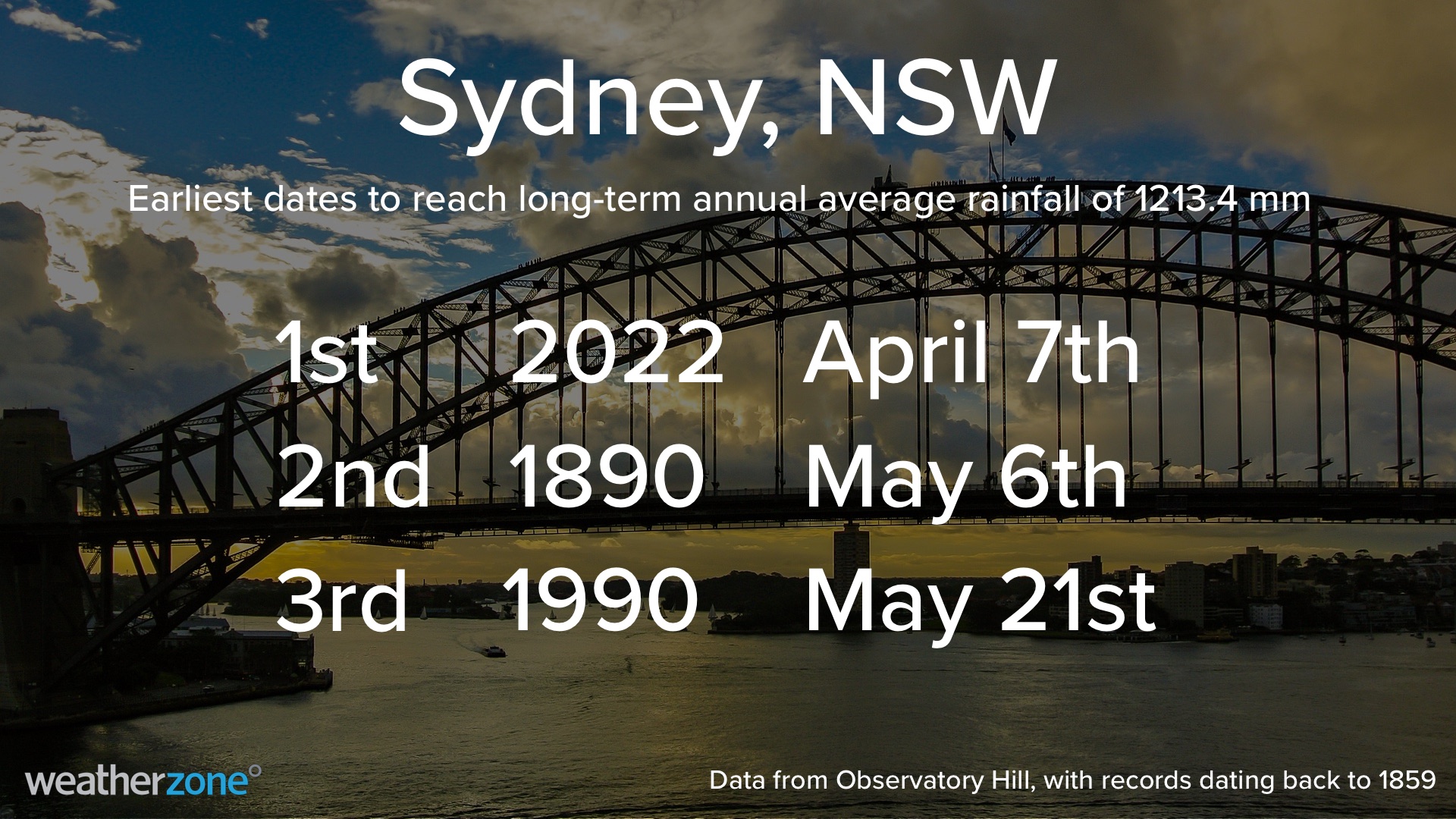
This latest deluge brings Sydney’s running annual total for 2022 up to 1226.8 mm, surpassing the city’s long-term annual average of 1213.4 mm.

This is the first time on record that Sydney has reached its annual average rainfall by April 7, beating the previous record by a month. The old record was May 6 in 1890.

Amid this unprecedented wet start to 2022, Sydney also notched up its wettest March on record and its wettest 16-day period on record between late-February and early-March.

Only time will tell is 2022 can challenge Sydney’s wettest calendar year on record, which was 2194.0 mm in 1950.

This year’s prolific rain has been caused by a series of atmospheric rivers feeding into slow-moving upper-level troughs over eastern Australia. This repetitive wet weather pattern was also responsible for the catastrophic flooding in northeast NSW and southeast QLD in February and March.

Heavy rain will continue to affect Sydney and other areas of eastern NSW during the next 24 to 48 hours. You can check the latest weather and flood warnings here. For more information on Weatherzone’s heavy rainfall, solar and wind forecasting, please contact us at apac.sales@dtn.com.

Latest news

Satisfy your weather obsession with these news headlines from around the nation, and the world.

Australia’s 2025–26 Cyclone Season: Slightly Above Average, Dominated by Severe Systems

Australia has just experienced a highly impactful tropical cyclone season, with more than 60% of systems reaching severe intensity, causing widespread disruption and damage to communities and multiple industries across northern Australia.  The 2025–26 Australian tropical cyclone season officially ran from 1 November 2025 to 30 April 2026. During this six-month period, Australia saw 11 tropical cyclones, with nine […]

What does a ‘super El Niño’ mean for Australia’s businesses?

There are signs that a very strong, or ‘super’ El Niño could develop in the tropical Pacific Ocean later this year. So, what does this mean for Australia’s weather during the second half of 2026? El Niño on the horizon The tropical Pacific Ocean is currently in a neutral state, meaning neither El Niño nor […]

How does DTN help businesses monitor bushfire induced pyrocumulonimbus thunderstorms that ignite more fires?

Intense heat from bushfires during elevated fire danger days can trigger fire-induced pyrocumulonimbus thunderstorms that ignite additional fires. In early January 2026, an extreme heatwave sweeping over southeastern Australia brought catastrophic fire danger to Victoria. Intensely hot bush and grass fires spread erratically and quickly in hot, dry and gusty winds, with pyrocumulonimbus generating lightning, […]

Active seas to the north and east of Australia disrupting port and maritime operations

Seas to the north and east of Australia are experiencing periods of increased activity this week, leading to disruptions to port, maritime and offshore operations. Intense and hazardous Tasman Sea Ocean conditions across NSW’s South Coast rapidly deteriorated last Friday as a deep feed of easterly winds whipped up large and dangerous seas. The Batemans […]