A quintessentially spring-like week is upon Australia, with a contrasting mix of thunderstorms in Queensland and Western Australia, cold and snow in Tasmania, heat in the Northern Territory and rain possibly developing in the southeast.
Storms in Queensland and NSW
A thunderstorm outbreak will be ramping up over eastern Qld and northeast NSW, with a peak expected on Wednesday afternoon.
A classic mixture of heat drifting in from the north and west, cold air pushing up from the south will collide with moisture from the east to create the perfect conditions for thunderstorms.
Brisbane is a high chance to see storms on Tuesday 8th afternoon, coinciding with a cool southerly wind change.
This system will maintain some strength with isolated thunderstorms continuing through the night, before becoming scattered to widespread across the region on Wednesday afternoon.
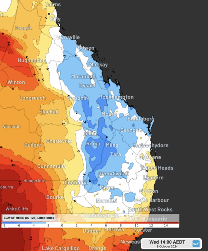
Image: Lifted Index values on Wednesday 9th afternoon. Areas with lower values (the white and blue shading) show where the atmosphere is potentially unstable, greatly increasing the risk of thunderstorms developing.
Thunderstorms are expected to be more isolated on Thursday as the system weakens, but some isolated heavy rain is possible as a coastal trough briefly forms. The most likely area to see this heavy rain is the Sunshine Coast and surrounds, with potential falls of 40-80mm in a 12-hour period on Wednesday night and Thursday morning.
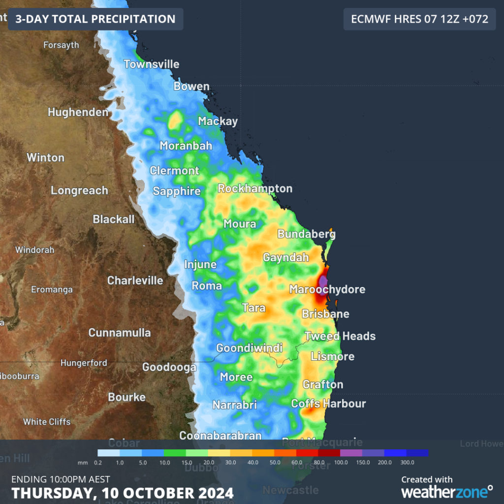
Image: Forecast rainfall between Tuesday and Thursday, showing widespread falls from storms expected, as well as an area of heavy rain associated with a coastal trough
As with most spring thunderstorm outbreaks, severe weather of large hail, heavy rainfall and damaging winds may accompany any thunderstorm. It is also the time of year where supercell thunderstorms are more common. These particularly dangerous types of storms can bring giant hail, destructive winds, intense rainfall, and even produce tornadoes.
Severe thunderstorms warnings will be issued for any thunderstorms displaying signs that they are producing these damaging side effects of storms. You can view the current official weather warnings here.
Heat and storms for WA and the NT
Thunderstorms are continuing to fire up each afternoon over the Pilbara and Gascoyne regions of WA, after last week’s burst of lightning activity. These storms will steadily become more scattered each day before peaking on Friday afternoon, as an upper trough lingers over the region. A weak rainband also looks to form, before moving south over the Southern Interior and western parts of SA over the weekend.
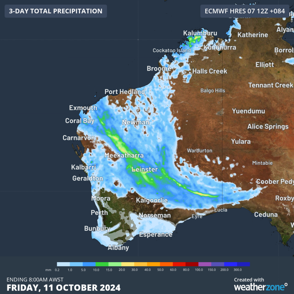
Image: Forecast rainfall over WA from Tuesday up to Friday morning. The streak of heaviest rain shows the position of the potential rainband
Meanwhile, a severe-to-extreme heatwave is continuing for the Kimberley and parts of the Top End, including Darwin. The relentless hot conditions, paired with tropical humidity, will continue until the weekend, the WA trough will link up, creating more thunderstorms and cooling down the airmass.
Temperature see-saw in Vic, Tas
Temperatures will be going up and down quite significantly in Victoria and Tasmania this week, with several cold fronts crossing, drawing heat in ahead of them. Melbourne’s forecast for the coming week exemplifies their rollercoaster spring weather: 14°C on Tuesday, 20-21°C on Wednesday and Thursday, 17-18°C on Friday and Saturday, and 24°C on Sunday.
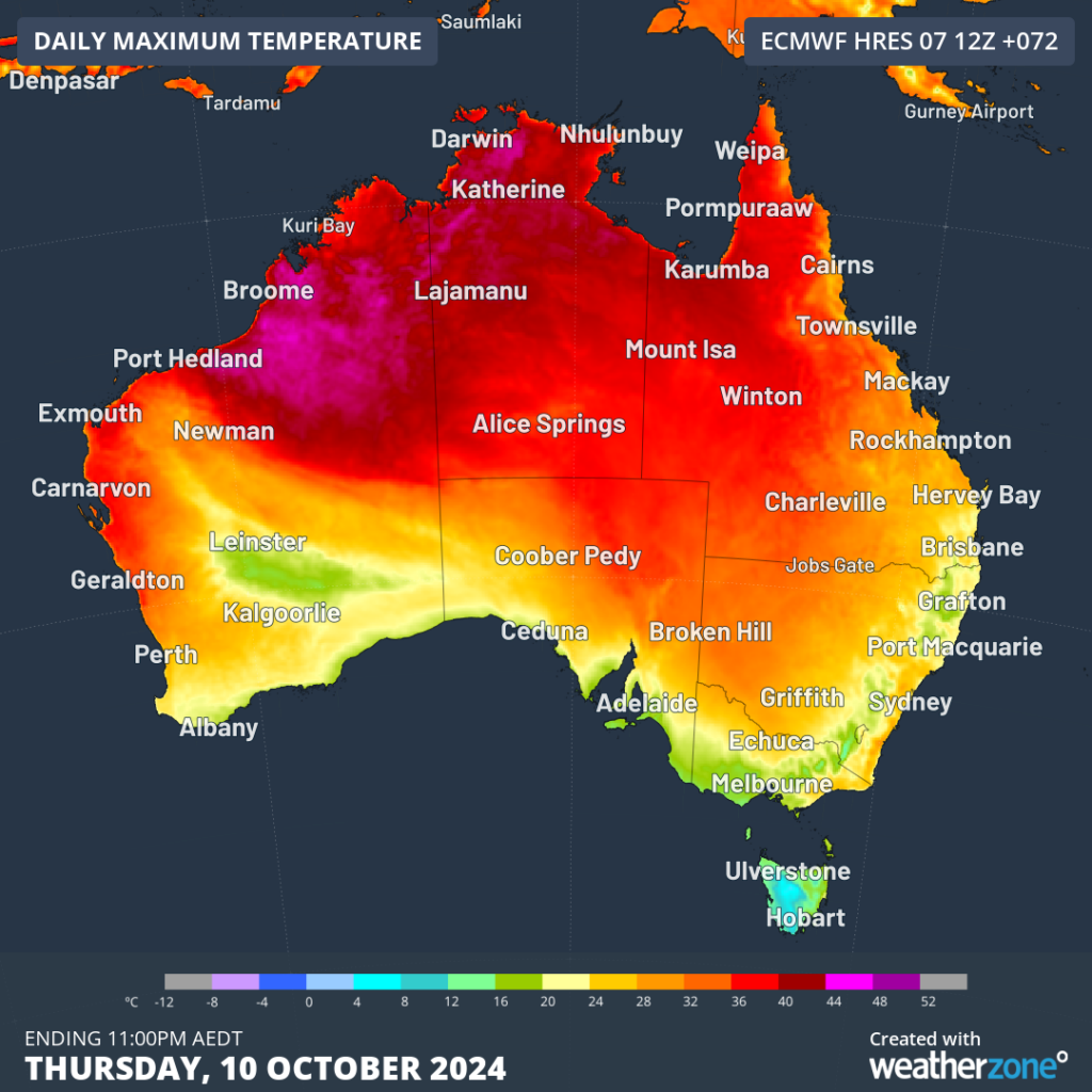
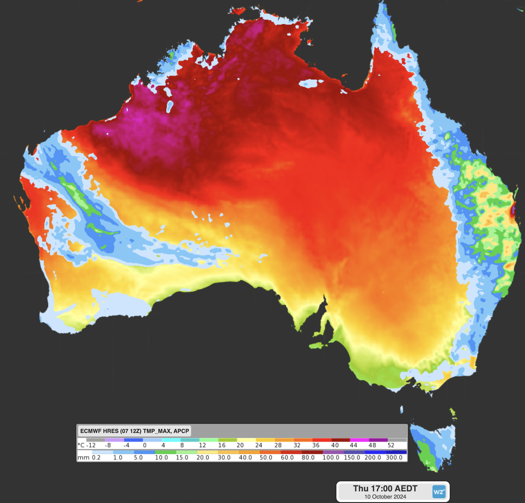
Image: Forecast maximum temperatures for Thursday. Parts of Tas are only expected to reach the mid-single figures, while temperatures climb into the mid-forties over northern parts of WA.
Rising pollen in SA
Hayfever sufferers won’t be happy to hear that pollen levels are expected to increase significantly over the weekend in SA, and early next week in the eastern states. As springtime crops start to flower and bloom, pollen gets picked up by the wind, often in the warm north-to-northwesterly winds, and dragged over the southern states and capital cities. This week, Adelaide is expected to see the worst, with a ‘very high’ pollen rating for Sunday, followed by ‘high’ ratings into next week for Sydney, Canberra and Melbourne.
All up the next seven days promise to showcase all the elements that make up a classic spring week, so enjoy all the highs and lows on offer.
How DTN APAC can help
Stormtracker is our Global Information System (GIS) tracking tool, providing multiple weather layers and zoom controls overlaid on a map of your location and infrastructure. You can choose a snapshot or full screen view, depending on your requirements. The maps allow you to monitor all weather, and specifically any systems likely to cause risk for your business. You also have the capacity to observe:
- real time lightning and thunderstorm alerts
- localised lightning strike frequency
- official warnings for storm, cyclone, wind, flood and fire
- sentinel hotspot fires and fire agency current incidents
Stormtracker’s radar imagery updates every 10 minutes, so you are always able to respond rapidly to changing conditions. You can customise alerting to notify you when your staff or infrastructure are under threat. With increased situational awareness, your ability to make informed decisions quickly is optimised.
DTN APAC’ experience and intelligence gives you a clear path through complex situations. Let us assist you, offering actionab le insight when extreme weather poses risk to your business. For more information, please visit our website or email us at apac.sales@dtn.com.


