
Welcome rain is coming to the parched southwest WA this week, possibly including Perth and Bunbury which are both having their driest 7 months on record.
Many locations in the southwest will see the driest April on record, with much of this rainfall likely to contribute to May’s totals, as a cold front approaches the state on later in the week.
Rainfall and thunderstorms are forecast in the Gascoyne region on Monday afternoon, before shifting to the Central West, Lower West and Central Wheatbelt regions on Tuesday. The heaviest falls are likely across the south and southwest of the state between Wednesday and Saturday.
Perth could also see several days with rainfall registered in the gauge from Tuesday, which will be welcome after the city experienced the driest six-month period between October and March.
The maps below shows two computer models forecast rainfall, with widespread falls between 5 to 10mm evident across the west and southwest between Monday and Sunday, with isolated falls of between 30 and 60mm.
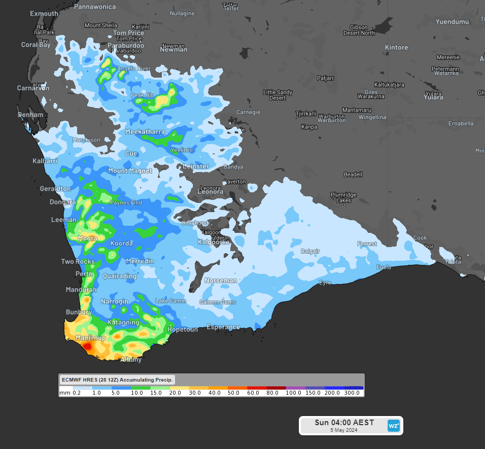
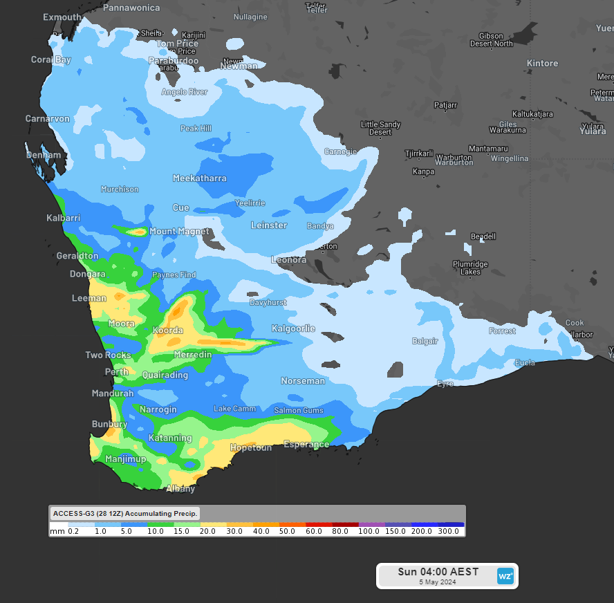
Images: Accumulated 6-day rainfall leading up to 2am AWST on Sunday, May 5, according to ECMWF (top) and ACCESS-G (bottom).
There is still some disagreement over how much rain will fall. Unfortunately, it seems likely that it will only be about a quarter of the rainfall we need.
The map below shows that parts of the region have endured a 150 to 300mm deficit during the last seven months.
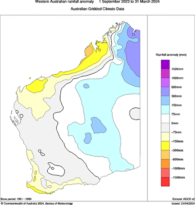
Image: WA rainfall anomaly between 1 September 2023 and March 31 2024, source: Bureau of Meteorology.
The lack of rainfall during this period has led to the soil moisture being the lowest one percent in the southwest in the deep layer, indicating that the dryness has penetrated below the surface. The map below shows the deep layer soil moisture in southwestern WA, which represents the percentage of available water content between 1 m and 6 m in the soil profile.
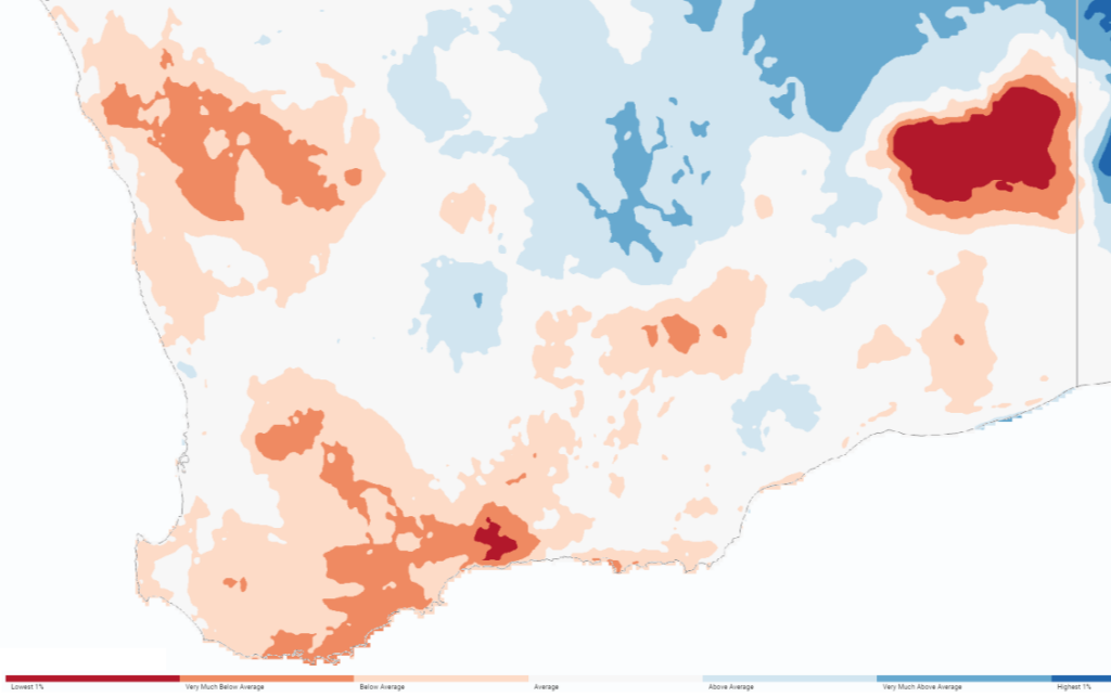
Image: Deep layer soil moisture in southwest WA as of Thursday, April 25, source: Bureau of Meteorology.
Though this rainfall is unlikely to be drought-breaking, it certainly will be useful over the coming week. We will be keeping an eye on the rainfall and thunderstorms that form this week in WA and update you as the event. unfolds.
Embedded in DTN APAC’ industry interfaces, the system gives you a time advantage when monitoring conditions developing over your infrastructure and location.
Stormtracker is our Global Information System (GIS) tracking tool, providing multiple weather layers and zoom controls overlaid on a map of your location and infrastructure. You can choose a snapshot or full screen view, depending on your requirements. The maps allow you to monitor all weather, and specifically any systems likely to cause risk for your business. You also have the capacity to observe:
- real time lightning and thunderstorm alerts
- localised lightning strike frequency
- official warnings for storm, cyclone, wind, flood and fire
- sentinel hotspot fires and fire agency current incidents
Stormtracker’s radar imagery updates every 10 minutes, so you are always able to respond rapidly to changing conditions. You can customise alerting to notify you when your staff or infrastructure are under threat. With increased situational awareness, your ability to make informed decisions quickly is optimised.
DTN APAC’ experience and intelligence gives you a clear path through complex situations. Let us assist you, offering actionable insight when extreme weather poses risk to your business. For more information, please contact us at apac.sales@dtn.com.


