Prosper in a dynamic world
Search

Perth’s dry start to 2022 continues


Perth only picked up 5 mm of rain during March as the city continues one of its driest starts to a year on record.

While large areas of eastern Australia were being inundated with heavy rain and flooding during March, Perth and many other areas of the country’s west coast were very dry.

The city only received 5mm of rain during the entire month, which is only one quarter of the long-term monthly average. It is also Perth’s driest March in four years.

Perth’s paltry March rainfall brought the city’s running total for 2022 up to 6.6 mm. This is the city’s lowest January-to-March total since 2mm in 2004.

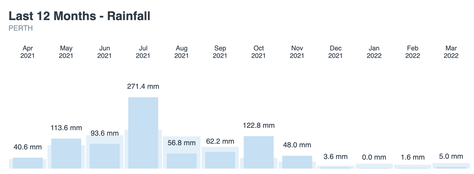
Image: Perth’s observed rainfall totals during the last 12 months, compared to the long-term averages for each month.

Perth’s dry weather in recent weeks and months has partially been caused by a prolonged positive phase of the Southern Annular Mode (SAM).

The SAM is an index that measures the north-south displacement of the westerly winds that flow between Australia and Antarctica. When the SAM is positive, these westerlies shift further south, which can limit rainfall over southwestern Australia.

By contrast, a positive SAM typically increases rainfall over eastern Australia during summer, and this was certainly the case in March. While Perth only saw 5 mm of rain during the month, Sydney collected 554 mm.

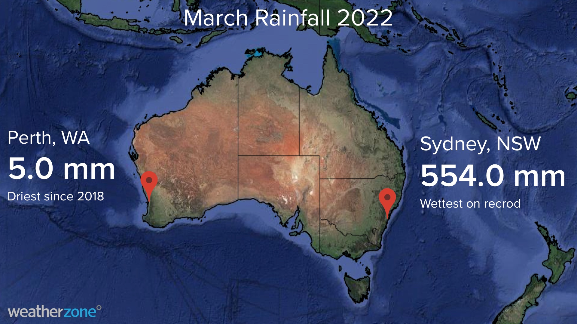
Sydney’s March rain was a new record for the city. It also brings Sydney’s running annual total up to 1076.2 mm, which is the highest January-to-March total in records dating back to 1859.

Weatherzone’s long-range forecasts from November last year indicated a wet March across eastern Australia, while a dry month for the west. This forecast was based on climate drivers such as positive SAM and La Niña, which both influence Australia’s weather. For more information on our seasonal forecasts which include rainfall, heavy rainfall and flood, heat extremes and heatwaves and thunderstorm risks and forecasts, please contact us at apac.sales@dtn.com.


Latest news

Satisfy your weather obsession with these news headlines from around the nation, and the world.

El Niño Is Here: What a Potential Record Event Means for Southeast Asia and Australia

  El Niño was officially declared in June 2026, raising the prospect of widespread impacts across Southeast Asia, from extreme heat and water shortages to higher energy demand and agricultural stress.   The World Meteorological Organization has warned countries to “prepare for it to be severe”, while several global forecast models suggest the event could rank among […]

How El Niño will shape Australian port operations in winter-spring 2026

Australian ports and marine pilots can expect a season of shifting wind and swell patterns through winter and spring 2026, as a developing El Niño brings the likelihood of drier conditions and more variable operating windows across the country’s coastline.  Will El Niño develop in 2026?  There are clear signs that an El Niño pattern is becoming […]

From Kimberley to northern NSW: Bushfire outlook flags risk for resources sector this winter

Bushfire risk doesn’t usually make headlines in June, but AFAC’s winter seasonal outlook is putting mining and resources operators on alert from the Kimberley to the NSW.  Australia’s official seasonal bushfire outlook for winter 2026 was released by AFAC on Thursday, May 28. The outlook predicts increased fire risk across the northern parts of the Great Sandy Desert and surrounds […]

The signal was there weeks earlier: forecasting one of the year’s biggest wind events

In mid-May 2026, DTN APAC meteorologists flagged a strengthening Southern Ocean pattern in model guidance, signalling an extended run of record-challenging wind conditions across the NEM.  Nearly three weeks later, NEM wind generation climbed from around 1.5GW to more than 9GW, supplying roughly one-third of the grid and coming within 1GW of the all-time generation record.  The event highlighted […]