
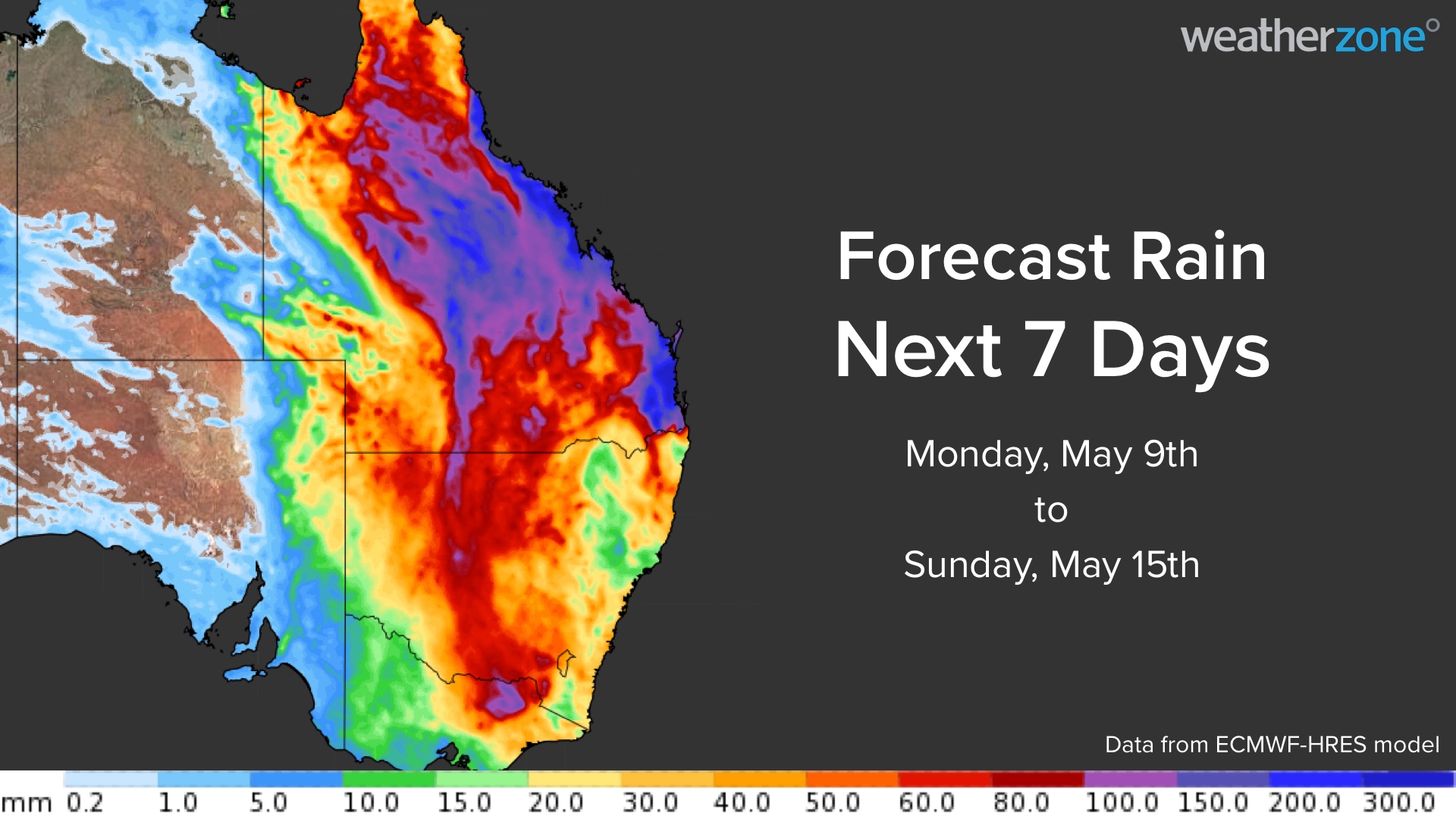
A rare late-autumn deluge will inundate QLD this week, causing life-threatening flooding and significant transport disruptions across the state.
A sustained stream of atmospheric moisture feeding into a slow-moving upper-level trough will produce widespread and heavy rain across the state during the next 4 to 5 days.
This weather pattern is very unusual for May and some parts of the state could see several months’ worth of rain in a single day. The map below shows that a broad area of QLD could pick up more than 100 mm from this system and some areas could see more than 300 mm. Some areas of NSW will also see heavy rain later in the week.

Monday
Showers are starting to become more widespread over QLD today as the upper-level trough moves over central Australia, towards QLD.
Heavy falls are unlikely for most areas on Monday, although large parts of the state could see 5 to 20 mm and isolated pockets of more than 50 mm are possible.

Image: Forecast accumulated rain on Monday, May 9, according to the ECMWF-HRES model.
Tuesday
Rainfall will become widespread and heavy as the upper-level trough moves over the stare from the west, with flooding through some inland districts. Some rain will also spread into northern NSW late in the day.
A severe weather warning has been issued for several districts in Central Western QLD due to heavy rain that is expected to start falling from Tuesday morning and continue throughout the day.
Daily rainfall totals of around 50 to 100 mm are likely across the central and northern inland of QLD, with isolated totals possibly reaching 150 to 200 millimeters. Some areas could also see six-hourly rain rates exceeding 100 mm with intense thunderstorms.
These rainfall rates may lead to life-threatening flooding, particularly across inland QLD where the ground is flat.

Image: Forecast accumulated rain on Tuesday, May 10, according to the ECMWF-HRES model.
Wednesday
Heavy rain will continue across parts of inland QLD and northern NSW on Wednesday, while also spreading east towards the coast.
Widespread daily falls of 100 to 150 mm are forecast over the central and northern coast and inland, with totals possibly exceeding 250 mm in some areas. Six-hourly rainfall rates are likely to reach 60 to 120 mm and may exceed 150 mm in thunderstorms.
There is also potential for locally heavy rain to develop over parts southern QLD and northern NSW on Wednesday as tropical moisture starts to drift further south.

Image: Forecast accumulated rain on Wednesday, May 11, according to the ECMWF-HRES model.
Thursday onwards
Rain is likely to continue over parts of QLD and NSW on Thursday and Friday, with more heavy rain targeting eastern QLD as a low-pressure system develops near the coast. However, there is some uncertainty regarding the position of the low and as a result, where the heaviest rain will fall.
The map below shows the forecast rainfall for Thursday and Friday from three different computer models, with some models suggesting heavy rainfall could shift south impacting parts of southeastern QLD.


Image: Forecast accumulated rain on Thursday (top) and Friday (bottom) according to three different forecast models.
This week’s rain is unseasonable for May and could impact industries and communities across both states that are not accustomed to these conditions at this time of year:
- Flooding is likely to cause prolonged disruptions to transport routes and power networks
- Low-lying parts of the landscape, such as mines, lakes and rivers, could become inundated by flash floods
- Increased cloud cover will reduce solar power generation across parts of eastern Australia
- Reduced visibility in heavy rain could affect aviation and port operations
- It may become dangerous to travel at times, with life-threatening flash flooding a risk in some areas, both near the coast and in the outback
Any communities or industries in QLD and northern NSW should pay close attention to the latest forecasts and warnings throughout the week, as these will continue to be updated with the latest model data. For more information on Weatherzone’s heavy rainfall forecast and alerting system, please contact us at apac.sales@dtn.com.




